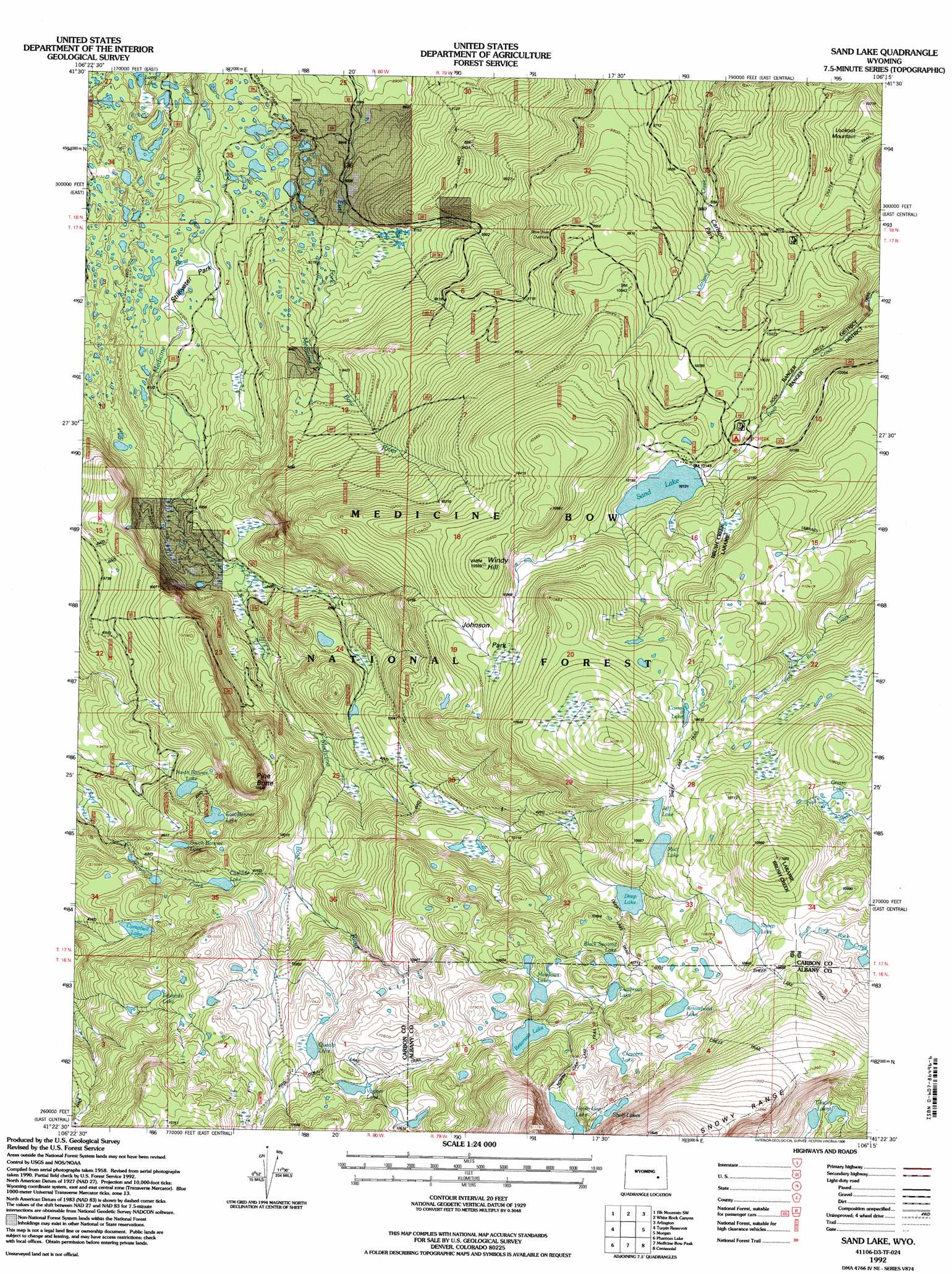
Sand Lake Topo Map Wyoming
To zoom in, hover over the map of Sand Lake
USGS Topo Quad 41106d3 - 1:24,000 scale
| Topo Map Name: | Sand Lake |
| USGS Topo Quad ID: | 41106d3 |
| Print Size: | ca. 21 1/4" wide x 27" high |
| Southeast Coordinates: | 41.375° N latitude / 106.25° W longitude |
| Map Center Coordinates: | 41.4375° N latitude / 106.3125° W longitude |
| U.S. State: | WY |
| Filename: | o41106d3.jpg |
| Download Map JPG Image: | Sand Lake topo map 1:24,000 scale |
| Map Type: | Topographic |
| Topo Series: | 7.5´ |
| Map Scale: | 1:24,000 |
| Source of Map Images: | United States Geological Survey (USGS) |
| Alternate Map Versions: |
Sand Lake WY 1961, updated 1963 Download PDF Buy paper map Sand Lake WY 1961, updated 1967 Download PDF Buy paper map Sand Lake WY 1961, updated 1984 Download PDF Buy paper map Sand Lake WY 1992, updated 1996 Download PDF Buy paper map Sand Lake WY 2012 Download PDF Buy paper map Sand Lake WY 2015 Download PDF Buy paper map |
| FStopo: | US Forest Service topo Sand Lake is available: Download FStopo PDF Download FStopo TIF |
1:24,000 Topo Quads surrounding Sand Lake
Rattlesnake Pass |
Elk Mountain |
T L Ranch |
Mcfadden |
Pierce Reservoir |
Coad Mountain |
Elk Mountain Sw |
White Rock Canyon |
Arlington |
Bengough Hill |
Kennaday Peak |
Turpin Reservoir |
Sand Lake |
Morgan |
Strouss Hill |
Ryan Park |
Phantom Lake |
Medicine Bow Peak |
Centennial |
Rex Lake |
Barcus Peak |
Overlook Hill |
Keystone |
Albany |
Lake Owen |
> Back to 41106a1 at 1:100,000 scale
> Back to 41106a1 at 1:250,000 scale
> Back to U.S. Topo Maps home
Sand Lake topo map: Gazetteer
Sand Lake: Dams
Corpening Dam elevation 3104m 10183′Wheatland Reservoir Dam elevation 3103m 10180′
Sand Lake: Flats
Johnson Park elevation 3174m 10413′Stillwater Park elevation 2775m 9104′
Sand Lake: Lakes
Arrowhead Lake elevation 3284m 10774′Black Spotted Lake elevation 3250m 10662′
Campbell Lake elevation 3058m 10032′
Cascade Lake elevation 3077m 10095′
Corral Lake elevation 3232m 10603′
Crescent Lake elevation 3284m 10774′
Cutthoat Lake elevation 3255m 10679′
Deep Lake elevation 3199m 10495′
Drillers Lake elevation 3079m 10101′
East Banner Lake elevation 3065m 10055′
Edwards Lake elevation 3132m 10275′
Glacier Lakes elevation 3293m 10803′
Grassy Lake elevation 3266m 10715′
Jeff Lake elevation 3241m 10633′
Little Long Lake elevation 3231m 10600′
Meadows Lakes elevation 3237m 10620′
Mutt Lake elevation 3241m 10633′
North Banner Lake elevation 3028m 9934′
North Gap Lake elevation 3327m 10915′
Quealy Lake elevation 3152m 10341′
Reservoir Lake elevation 3284m 10774′
Sand Lake elevation 3089m 10134′
Sheep Lake elevation 3284m 10774′
Shelf Lakes elevation 3345m 10974′
South Banner Lake elevation 3036m 9960′
Upper Long Lake elevation 3153m 10344′
Vagner Lake elevation 3185m 10449′
Vosseller Lake elevation 3231m 10600′
Sand Lake: Mines
Golden Crown Mining Syndicate Mine elevation 3054m 10019′Waterloo Prospect elevation 2757m 9045′
Sand Lake: Reservoirs
Corpening Reservoir elevation 3104m 10183′Sand Lake Reservoir elevation 3103m 10180′
Sand Lake: Summits
Lookout Mountain elevation 3124m 10249′Pine Butte elevation 3210m 10531′
Windy Hill elevation 3220m 10564′
Sand Lake digital topo map on disk
Buy this Sand Lake topo map showing relief, roads, GPS coordinates and other geographical features, as a high-resolution digital map file on DVD:
Eastern Wyoming & Western South Dakota
Buy digital topo maps: Eastern Wyoming & Western South Dakota