Finley Reservoir Topo Map Wyoming
To zoom in, hover over the map of Finley Reservoir
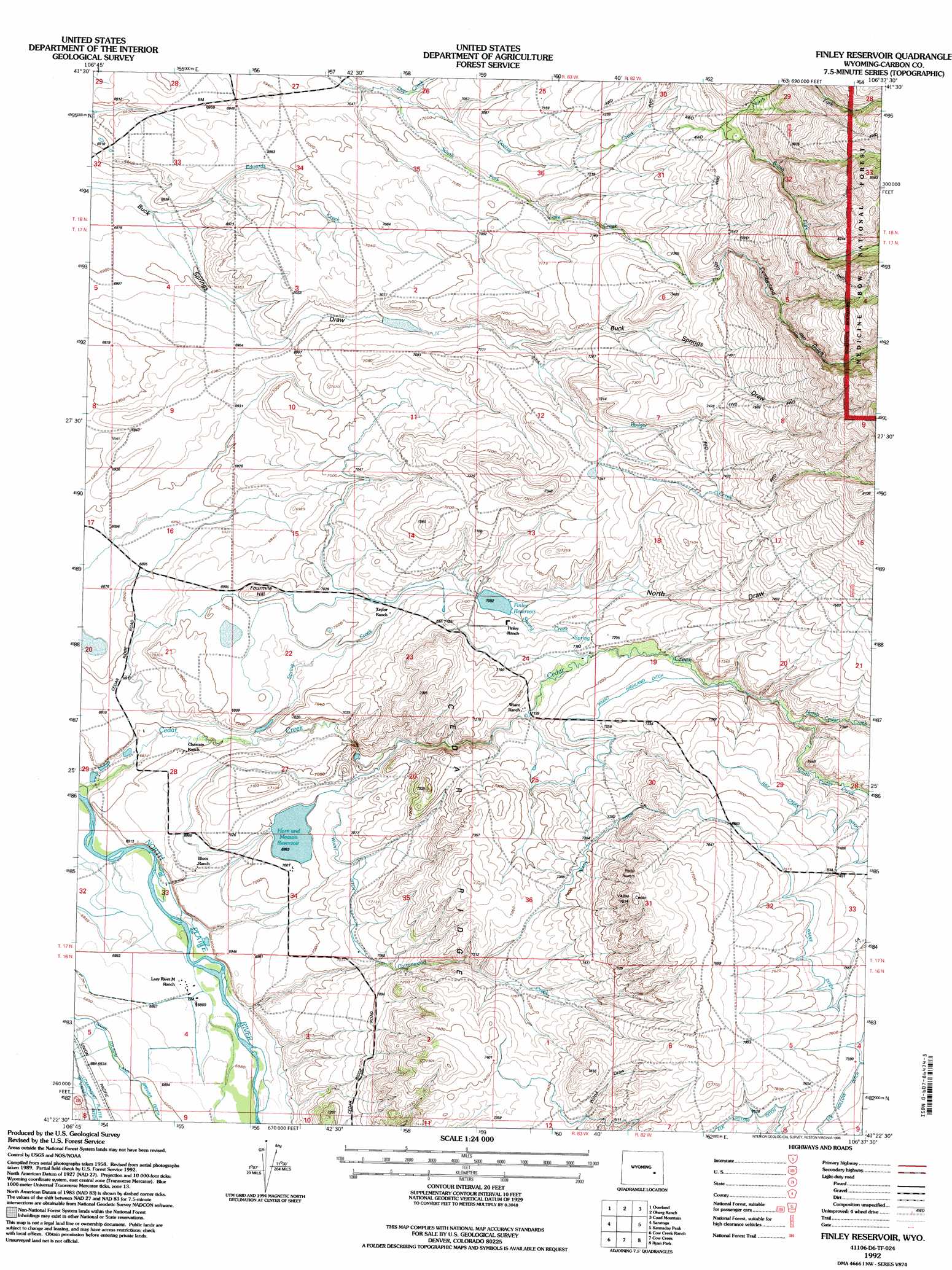
USGS Topo Quad 41106d6 - 1:24,000 scale
| Topo Map Name: | Finley Reservoir |
| USGS Topo Quad ID: | 41106d6 |
| Print Size: | ca. 21 1/4" wide x 27" high |
| Southeast Coordinates: | 41.375° N latitude / 106.625° W longitude |
| Map Center Coordinates: | 41.4375° N latitude / 106.6875° W longitude |
| U.S. State: | WY |
| Filename: | o41106d6.jpg |
| Download Map JPG Image: | Finley Reservoir topo map 1:24,000 scale |
| Map Type: | Topographic |
| Topo Series: | 7.5´ |
| Map Scale: | 1:24,000 |
| Source of Map Images: | United States Geological Survey (USGS) |
| Alternate Map Versions: |
Finley Reservoir WY 1961, updated 1963 Download PDF Buy paper map Finley Reservoir WY 1961, updated 1968 Download PDF Buy paper map Finley Reservoir WY 1961, updated 1984 Download PDF Buy paper map Finley Reservoir WY 1992, updated 1996 Download PDF Buy paper map Finley Reservoir WY 2012 Download PDF Buy paper map Finley Reservoir WY 2015 Download PDF Buy paper map |
| FStopo: | US Forest Service topo Finley Reservoir is available: Download FStopo PDF Download FStopo TIF |
1:24,000 Topo Quads surrounding Finley Reservoir
Savage Ranch |
Meads |
Coal Bank Basin |
Rattlesnake Pass |
Elk Mountain |
Overland Crossing |
Overland |
Oberg Ranch |
Coad Mountain |
Elk Mountain Sw |
Walck Ranch |
Saratoga |
Finley Reservoir |
Kennaday Peak |
Turpin Reservoir |
Indian Rocks |
Cow Creek Ranch |
Cow Creek |
Ryan Park |
Phantom Lake |
Red Mountain |
Encampment |
Gunst Reservoir |
Barcus Peak |
Overlook Hill |
> Back to 41106a1 at 1:100,000 scale
> Back to 41106a1 at 1:250,000 scale
> Back to U.S. Topo Maps home
Finley Reservoir topo map: Gazetteer
Finley Reservoir: Canals
Davis Folsom and Brewer Ditch elevation 2104m 6902′Hay Creek Ditch elevation 2278m 7473′
Wiant Ditch elevation 2290m 7513′
Wiant Highland Ditch elevation 2212m 7257′
Finley Reservoir: Dams
Finley Dam elevation 2160m 7086′Horn and Meason Dam elevation 2138m 7014′
Finley Reservoir: Reservoirs
Finley Reservoir elevation 2160m 7086′Horn and Meason Reservoir elevation 2132m 6994′
Finley Reservoir: Ridges
Cedar Ridge elevation 2258m 7408′Finley Reservoir: Streams
Badger Creek elevation 2161m 7089′Cottonwood Creek elevation 2096m 6876′
Deer Creek elevation 2123m 6965′
Edwards Creek elevation 2096m 6876′
Goetz Creek elevation 2131m 6991′
North Cedar Creek elevation 2219m 7280′
North Fork Goetz Creek elevation 2257m 7404′
North Fork Goetze Creek elevation 2502m 8208′
South Cedar Creek elevation 2220m 7283′
South Fork Goetz Creek elevation 2257m 7404′
Spring Creek elevation 2108m 6916′
Finley Reservoir: Summits
Fourmile Hill elevation 2155m 7070′Finley Reservoir: Valleys
Cumberland Gulch elevation 2233m 7326′North Draw elevation 2187m 7175′
Finley Reservoir digital topo map on disk
Buy this Finley Reservoir topo map showing relief, roads, GPS coordinates and other geographical features, as a high-resolution digital map file on DVD:
Eastern Wyoming & Western South Dakota
Buy digital topo maps: Eastern Wyoming & Western South Dakota