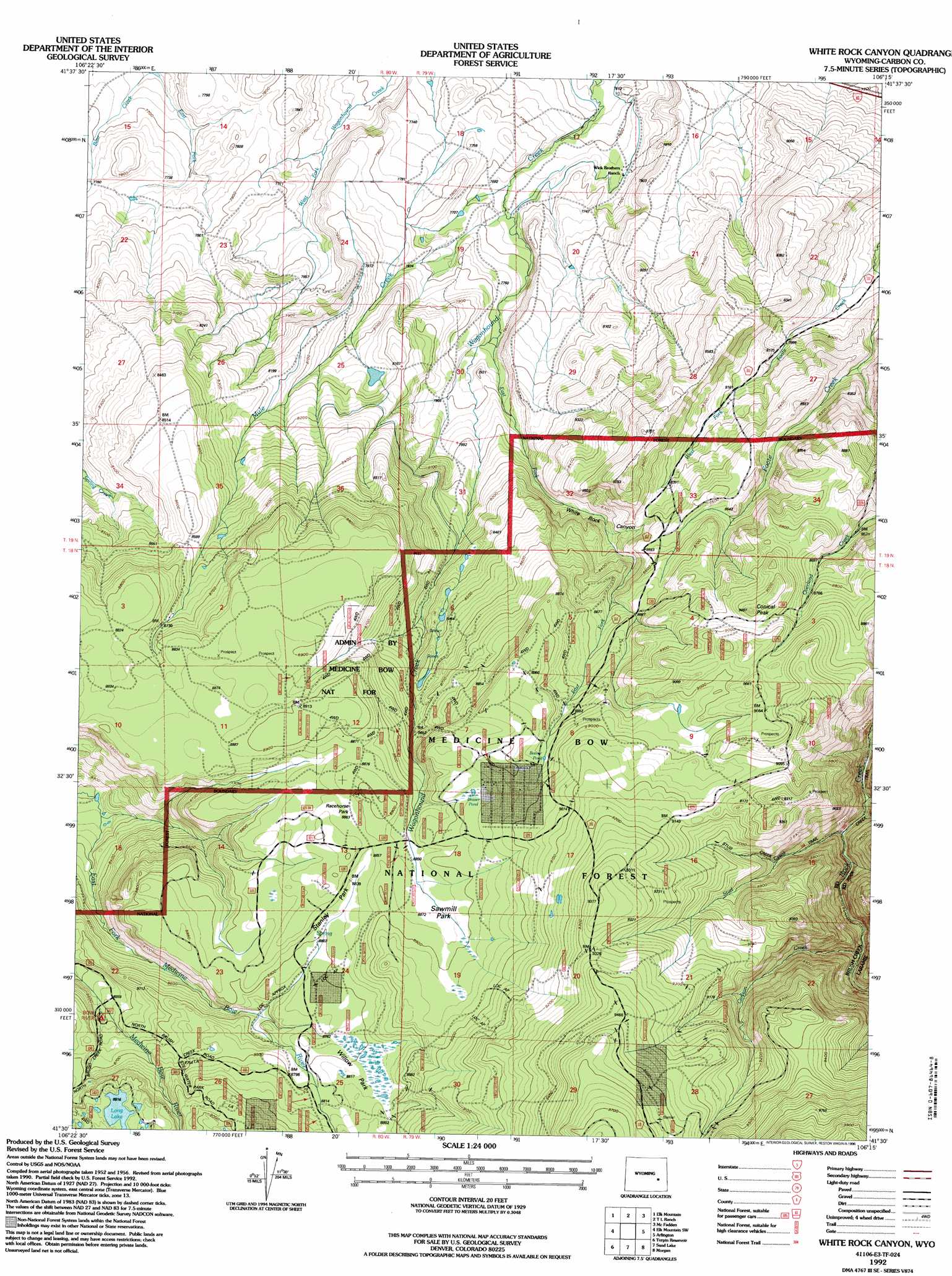
White Rock Canyon Topo Map Wyoming
To zoom in, hover over the map of White Rock Canyon
USGS Topo Quad 41106e3 - 1:24,000 scale
| Topo Map Name: | White Rock Canyon |
| USGS Topo Quad ID: | 41106e3 |
| Print Size: | ca. 21 1/4" wide x 27" high |
| Southeast Coordinates: | 41.5° N latitude / 106.25° W longitude |
| Map Center Coordinates: | 41.5625° N latitude / 106.3125° W longitude |
| U.S. State: | WY |
| Filename: | o41106e3.jpg |
| Download Map JPG Image: | White Rock Canyon topo map 1:24,000 scale |
| Map Type: | Topographic |
| Topo Series: | 7.5´ |
| Map Scale: | 1:24,000 |
| Source of Map Images: | United States Geological Survey (USGS) |
| Alternate Map Versions: |
White Rock Canyon WY 1958, updated 1959 Download PDF Buy paper map White Rock Canyon WY 1958, updated 1964 Download PDF Buy paper map White Rock Canyon WY 1958, updated 1983 Download PDF Buy paper map White Rock Canyon WY 1958, updated 1984 Download PDF Buy paper map White Rock Canyon WY 1992, updated 1996 Download PDF Buy paper map White Rock Canyon WY 2012 Download PDF Buy paper map White Rock Canyon WY 2015 Download PDF Buy paper map |
| FStopo: | US Forest Service topo White Rock Canyon is available: Download FStopo PDF Download FStopo TIF |
1:24,000 Topo Quads surrounding White Rock Canyon
Hanna |
Carbon |
Halfway Hill |
Pine Ridge |
Foote Creek Lake |
Rattlesnake Pass |
Elk Mountain |
T L Ranch |
Mcfadden |
Pierce Reservoir |
Coad Mountain |
Elk Mountain Sw |
White Rock Canyon |
Arlington |
Bengough Hill |
Kennaday Peak |
Turpin Reservoir |
Sand Lake |
Morgan |
Strouss Hill |
Ryan Park |
Phantom Lake |
Medicine Bow Peak |
Centennial |
Rex Lake |
> Back to 41106e1 at 1:100,000 scale
> Back to 41106a1 at 1:250,000 scale
> Back to U.S. Topo Maps home
White Rock Canyon topo map: Gazetteer
White Rock Canyon: Flats
Racehorse Park elevation 2706m 8877′Sawmill Park elevation 2705m 8874′
Stanley Park elevation 2695m 8841′
Willow Park elevation 2690m 8825′
White Rock Canyon: Lakes
Long Lake elevation 2720m 8923′White Rock Canyon: Streams
Carlson Creek elevation 2598m 8523′East Fork Bear Creek elevation 2326m 7631′
East Fork Wagonhound Creek elevation 2429m 7969′
Elk Creek elevation 2524m 8280′
Stud Creek elevation 2530m 8300′
West Fork Foote Creek elevation 2388m 7834′
White Rock Canyon: Summits
Conical Peak elevation 2753m 9032′White Rock Canyon: Valleys
White Rock Canyon elevation 2335m 7660′White Rock Canyon digital topo map on disk
Buy this White Rock Canyon topo map showing relief, roads, GPS coordinates and other geographical features, as a high-resolution digital map file on DVD:
Eastern Wyoming & Western South Dakota
Buy digital topo maps: Eastern Wyoming & Western South Dakota