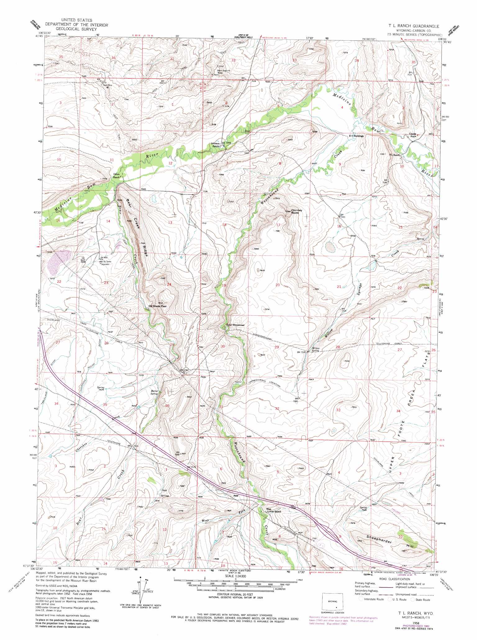
T L Ranch Topo Map Wyoming
To zoom in, hover over the map of T L Ranch
USGS Topo Quad 41106f3 - 1:24,000 scale
| Topo Map Name: | T L Ranch |
| USGS Topo Quad ID: | 41106f3 |
| Print Size: | ca. 21 1/4" wide x 27" high |
| Southeast Coordinates: | 41.625° N latitude / 106.25° W longitude |
| Map Center Coordinates: | 41.6875° N latitude / 106.3125° W longitude |
| U.S. State: | WY |
| Filename: | o41106f3.jpg |
| Download Map JPG Image: | T L Ranch topo map 1:24,000 scale |
| Map Type: | Topographic |
| Topo Series: | 7.5´ |
| Map Scale: | 1:24,000 |
| Source of Map Images: | United States Geological Survey (USGS) |
| Alternate Map Versions: |
T L Ranch WY 1958, updated 1960 Download PDF Buy paper map T L Ranch WY 1958, updated 1967 Download PDF Buy paper map T L Ranch WY 1958, updated 1983 Download PDF Buy paper map T L Ranch WY 2012 Download PDF Buy paper map T L Ranch WY 2015 Download PDF Buy paper map |
1:24,000 Topo Quads surrounding T L Ranch
Elmo |
Como West |
Como East |
Medicine Bow |
Aurora Lake |
Hanna |
Carbon |
Halfway Hill |
Pine Ridge |
Foote Creek Lake |
Rattlesnake Pass |
Elk Mountain |
T L Ranch |
Mcfadden |
Pierce Reservoir |
Coad Mountain |
Elk Mountain Sw |
White Rock Canyon |
Arlington |
Bengough Hill |
Kennaday Peak |
Turpin Reservoir |
Sand Lake |
Morgan |
Strouss Hill |
> Back to 41106e1 at 1:100,000 scale
> Back to 41106a1 at 1:250,000 scale
> Back to U.S. Topo Maps home
T L Ranch topo map: Gazetteer
T L Ranch: Canals
Cherokee Gulch Ditch elevation 2280m 7480′T L Ranch: Dams
Willow Springs Dam elevation 2166m 7106′T L Ranch: Mines
Black Diamond Mines elevation 2183m 7162′Carbon Basin Mine elevation 2206m 7237′
Johnson Mine elevation 2227m 7306′
Kent Mine elevation 2233m 7326′
T L Ranch: Populated Places
Old Brooks Place elevation 2199m 7214′T L Ranch: Reservoirs
Willow Springs Reservoir elevation 2166m 7106′T L Ranch: Ridges
Bear Creek Ridge elevation 2271m 7450′T L Ranch: Springs
Barrel Spring elevation 2265m 7431′Willow Spring elevation 2209m 7247′
T L Ranch: Streams
Bear Creek elevation 2156m 7073′Cherokee Creek elevation 2244m 7362′
Mule Creek elevation 2279m 7477′
Wagonhound Creek elevation 2107m 6912′
West Fork Wagonhound Creek elevation 2266m 7434′
T L Ranch: Summits
Castle Rock elevation 2119m 6952′Chimney Rocks elevation 2188m 7178′
Sheepherder Hill elevation 2423m 7949′
T L Ranch digital topo map on disk
Buy this T L Ranch topo map showing relief, roads, GPS coordinates and other geographical features, as a high-resolution digital map file on DVD:
Eastern Wyoming & Western South Dakota
Buy digital topo maps: Eastern Wyoming & Western South Dakota