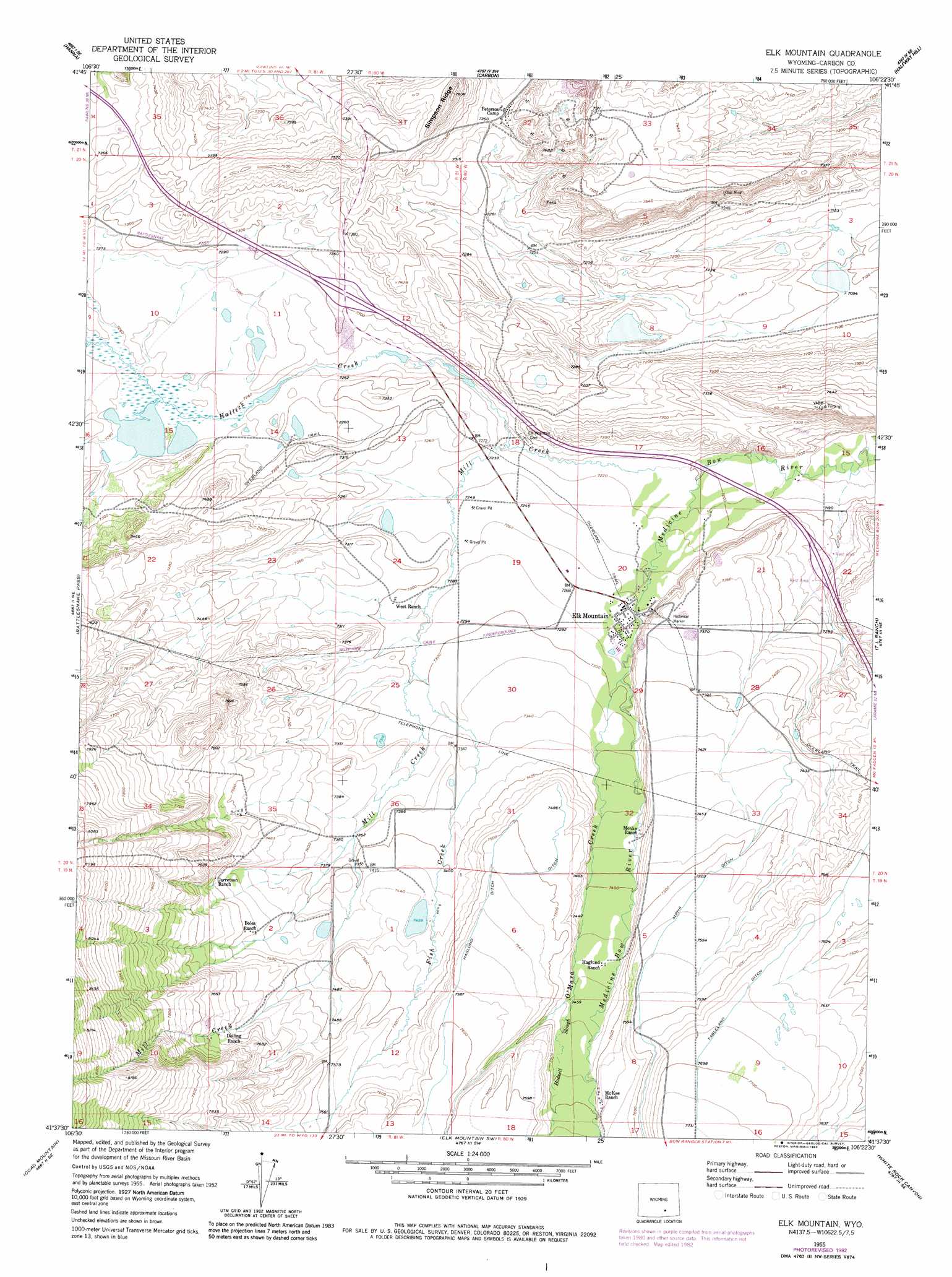
Elk Mountain Topo Map Wyoming
To zoom in, hover over the map of Elk Mountain
USGS Topo Quad 41106f4 - 1:24,000 scale
| Topo Map Name: | Elk Mountain |
| USGS Topo Quad ID: | 41106f4 |
| Print Size: | ca. 21 1/4" wide x 27" high |
| Southeast Coordinates: | 41.625° N latitude / 106.375° W longitude |
| Map Center Coordinates: | 41.6875° N latitude / 106.4375° W longitude |
| U.S. State: | WY |
| Filename: | o41106f4.jpg |
| Download Map JPG Image: | Elk Mountain topo map 1:24,000 scale |
| Map Type: | Topographic |
| Topo Series: | 7.5´ |
| Map Scale: | 1:24,000 |
| Source of Map Images: | United States Geological Survey (USGS) |
| Alternate Map Versions: |
Elk Mountain WY 1955, updated 1957 Download PDF Buy paper map Elk Mountain WY 1955, updated 1966 Download PDF Buy paper map Elk Mountain WY 1955, updated 1983 Download PDF Buy paper map Elk Mountain WY 2012 Download PDF Buy paper map Elk Mountain WY 2015 Download PDF Buy paper map |
1:24,000 Topo Quads surrounding Elk Mountain
Tenmile Spring |
Elmo |
Como West |
Como East |
Medicine Bow |
Dana |
Hanna |
Carbon |
Halfway Hill |
Pine Ridge |
Coal Bank Basin |
Rattlesnake Pass |
Elk Mountain |
T L Ranch |
Mcfadden |
Oberg Ranch |
Coad Mountain |
Elk Mountain Sw |
White Rock Canyon |
Arlington |
Finley Reservoir |
Kennaday Peak |
Turpin Reservoir |
Sand Lake |
Morgan |
> Back to 41106e1 at 1:100,000 scale
> Back to 41106a1 at 1:250,000 scale
> Back to U.S. Topo Maps home
Elk Mountain topo map: Gazetteer
Elk Mountain: Canals
Tableland Ditch elevation 2347m 7700′Elk Mountain: Mines
Carbon County Mine elevation 2269m 7444′Elk Mountain Prospect elevation 2259m 7411′
Elk Mountain Strip Mine Number Five elevation 2275m 7463′
Elk Mountain Strip Mine Number Four elevation 2268m 7440′
Elk Mountain Strip Mine Number One elevation 2269m 7444′
Elk Mountain Strip Mine Number Three elevation 2275m 7463′
Elk Mountain Valley Strip Mine elevation 2238m 7342′
Garey Mine elevation 2238m 7342′
Gebhart Mine elevation 2275m 7463′
Johnson Mine elevation 2275m 7463′
West Mine elevation 2283m 7490′
Elk Mountain: Populated Places
Elk Mountain elevation 2214m 7263′Elk Mountain: Ranges
Saddleback Hills elevation 2280m 7480′Elk Mountain: Streams
Fish Creek elevation 2225m 7299′Hadsell Slough elevation 2270m 7447′
Halleck Creek elevation 2201m 7221′
Mill Creek elevation 2195m 7201′
O'Mara Creek elevation 2227m 7306′
Elk Mountain: Valleys
Big Draw elevation 2277m 7470′Elk Mountain digital topo map on disk
Buy this Elk Mountain topo map showing relief, roads, GPS coordinates and other geographical features, as a high-resolution digital map file on DVD:
Eastern Wyoming & Western South Dakota
Buy digital topo maps: Eastern Wyoming & Western South Dakota