Carbon Topo Map Wyoming
To zoom in, hover over the map of Carbon
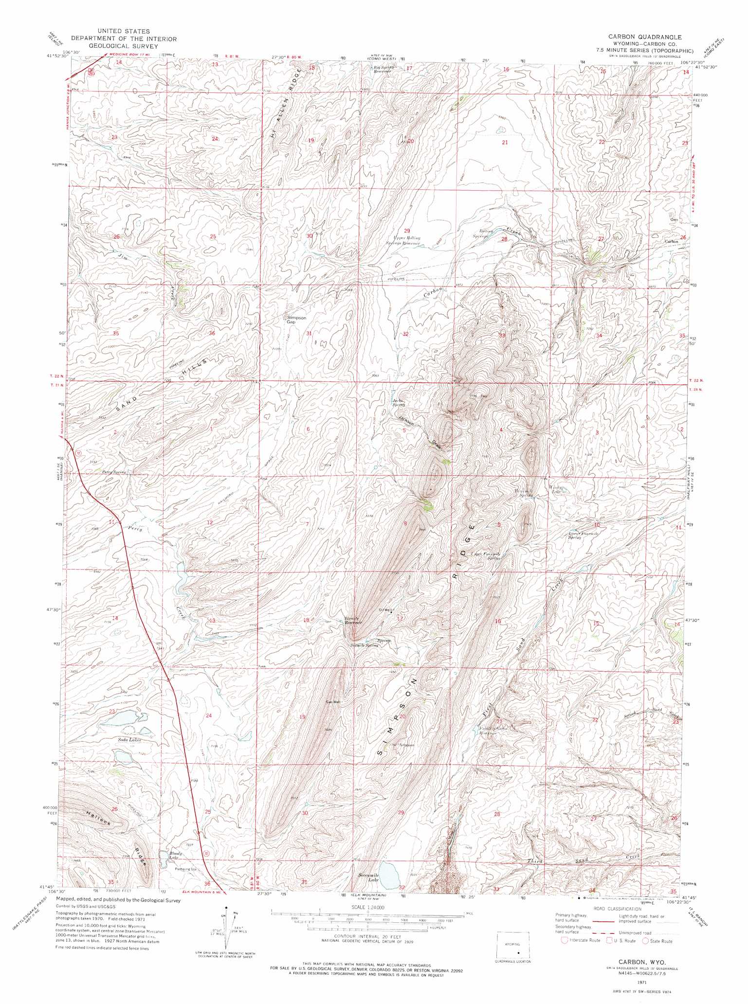
USGS Topo Quad 41106g4 - 1:24,000 scale
| Topo Map Name: | Carbon |
| USGS Topo Quad ID: | 41106g4 |
| Print Size: | ca. 21 1/4" wide x 27" high |
| Southeast Coordinates: | 41.75° N latitude / 106.375° W longitude |
| Map Center Coordinates: | 41.8125° N latitude / 106.4375° W longitude |
| U.S. State: | WY |
| Filename: | o41106g4.jpg |
| Download Map JPG Image: | Carbon topo map 1:24,000 scale |
| Map Type: | Topographic |
| Topo Series: | 7.5´ |
| Map Scale: | 1:24,000 |
| Source of Map Images: | United States Geological Survey (USGS) |
| Alternate Map Versions: |
Carbon WY 1971, updated 1975 Download PDF Buy paper map Carbon WY 2012 Download PDF Buy paper map Carbon WY 2015 Download PDF Buy paper map |
1:24,000 Topo Quads surrounding Carbon
Schneider Ridge |
T E Ranch |
Difficulty |
Windy Hill |
T B Ranch |
Tenmile Spring |
Elmo |
Como West |
Como East |
Medicine Bow |
Dana |
Hanna |
Carbon |
Halfway Hill |
Pine Ridge |
Coal Bank Basin |
Rattlesnake Pass |
Elk Mountain |
T L Ranch |
Mcfadden |
Oberg Ranch |
Coad Mountain |
Elk Mountain Sw |
White Rock Canyon |
Arlington |
> Back to 41106e1 at 1:100,000 scale
> Back to 41106a1 at 1:250,000 scale
> Back to U.S. Topo Maps home
Carbon topo map: Gazetteer
Carbon: Dams
Irene Dam elevation 2155m 7070′Carbon: Gaps
Simpson Gap elevation 2171m 7122′Carbon: Lakes
Bloody Lake elevation 2196m 7204′Sevenmile Lake elevation 2234m 7329′
Soda Lakes elevation 2159m 7083′
Windy Lake elevation 2171m 7122′
Carbon: Mines
Carbon Number One Mine elevation 2082m 6830′Carbon Number Three Mine elevation 2086m 6843′
Elk Mountain Strip Mine Two elevation 2213m 7260′
Carbon: Populated Places
Carbon elevation 2082m 6830′Carbon: Reservoirs
Big Spring Reservoir elevation 2121m 6958′Fiddlers Green Reservoir elevation 2203m 7227′
Irene Reservoir elevation 2155m 7070′
Lower Fourmile Spring elevation 2164m 7099′
Sixmile Reservoir elevation 2193m 7194′
Threemile Spring elevation 2195m 7201′
Upper Rolling Springs Reservoir elevation 2123m 6965′
Carbon: Ridges
Simpson Ridge elevation 2341m 7680′Carbon: Springs
Jacks Spring elevation 2159m 7083′Percy Spring elevation 2152m 7060′
Rolling Springs elevation 2105m 6906′
Sixmile Spring elevation 2200m 7217′
Upper Fourmile Spring elevation 2219m 7280′
Carbon: Valleys
Jackson Draw elevation 2173m 7129′Carbon digital topo map on disk
Buy this Carbon topo map showing relief, roads, GPS coordinates and other geographical features, as a high-resolution digital map file on DVD:
Eastern Wyoming & Western South Dakota
Buy digital topo maps: Eastern Wyoming & Western South Dakota