Singer Peak Topo Map Wyoming
To zoom in, hover over the map of Singer Peak
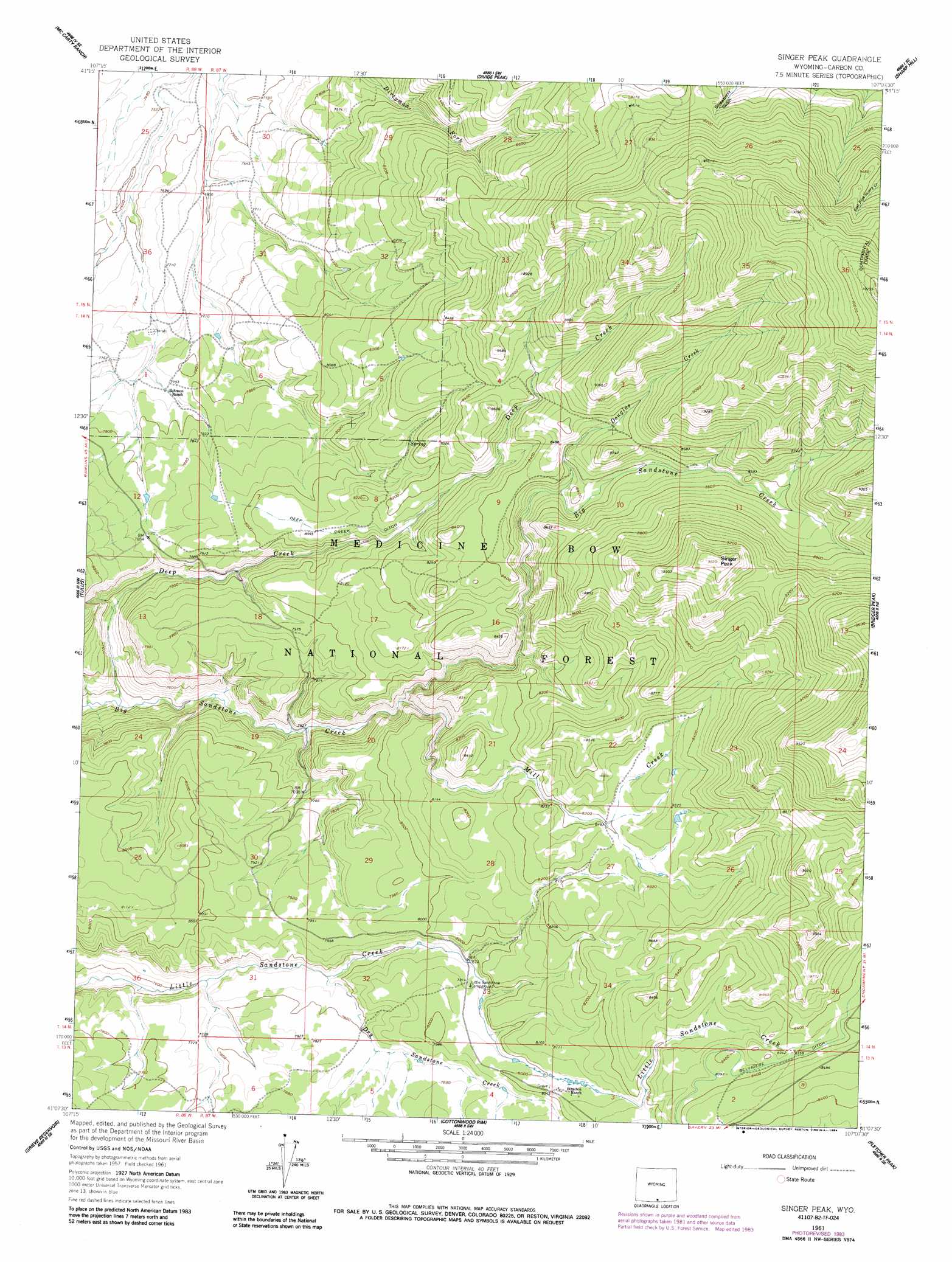
USGS Topo Quad 41107b2 - 1:24,000 scale
| Topo Map Name: | Singer Peak |
| USGS Topo Quad ID: | 41107b2 |
| Print Size: | ca. 21 1/4" wide x 27" high |
| Southeast Coordinates: | 41.125° N latitude / 107.125° W longitude |
| Map Center Coordinates: | 41.1875° N latitude / 107.1875° W longitude |
| U.S. State: | WY |
| Filename: | o41107b2.jpg |
| Download Map JPG Image: | Singer Peak topo map 1:24,000 scale |
| Map Type: | Topographic |
| Topo Series: | 7.5´ |
| Map Scale: | 1:24,000 |
| Source of Map Images: | United States Geological Survey (USGS) |
| Alternate Map Versions: |
Singer Peak WY 1961, updated 1963 Download PDF Buy paper map Singer Peak WY 1961, updated 1970 Download PDF Buy paper map Singer Peak WY 1961, updated 1984 Download PDF Buy paper map Singer Peak WY 1961, updated 1984 Download PDF Buy paper map Singer Peak WY 2012 Download PDF Buy paper map Singer Peak WY 2015 Download PDF Buy paper map |
| FStopo: | US Forest Service topo Singer Peak is available: Download FStopo PDF Download FStopo TIF |
1:24,000 Topo Quads surrounding Singer Peak
Pole Gulch |
Pine Grove Ranch |
Middlewood Hill |
Jack Creek Reservoir |
Walck Ranch |
Ketchum Buttes |
Mccarty Ranch |
Divide Peak |
Sharp Hill |
Indian Rocks |
Browns Hill |
Tullis |
Singer Peak |
Bridger Peak |
Red Mountain |
Savery |
Grieve Reservoir |
Cottonwood Rim |
Fletcher Peak |
Solomon Creek |
Bakers Peak |
Fly Creek |
Tumble Mountain |
Shield Mountain |
Elkhorn Mountain |
> Back to 41107a1 at 1:100,000 scale
> Back to 41106a1 at 1:250,000 scale
> Back to U.S. Topo Maps home
Singer Peak topo map: Gazetteer
Singer Peak: Canals
Deep Creek Ditch elevation 2469m 8100′Singer Peak: Mines
Gold Coin Prospect elevation 2590m 8497′Singer Peak: Streams
Deep Creek elevation 2247m 7372′Douglas Creek elevation 2524m 8280′
Dry Sandstone Creek elevation 2367m 7765′
Elk Creek elevation 2511m 8238′
Mill Creek elevation 2335m 7660′
Skull Creek elevation 2442m 8011′
Wickiup Creek elevation 2324m 7624′
Singer Peak: Summits
Singer Peak elevation 2902m 9520′Singer Peak digital topo map on disk
Buy this Singer Peak topo map showing relief, roads, GPS coordinates and other geographical features, as a high-resolution digital map file on DVD:
Eastern Wyoming & Western South Dakota
Buy digital topo maps: Eastern Wyoming & Western South Dakota