Lost Creek Butte Topo Map Wyoming
To zoom in, hover over the map of Lost Creek Butte
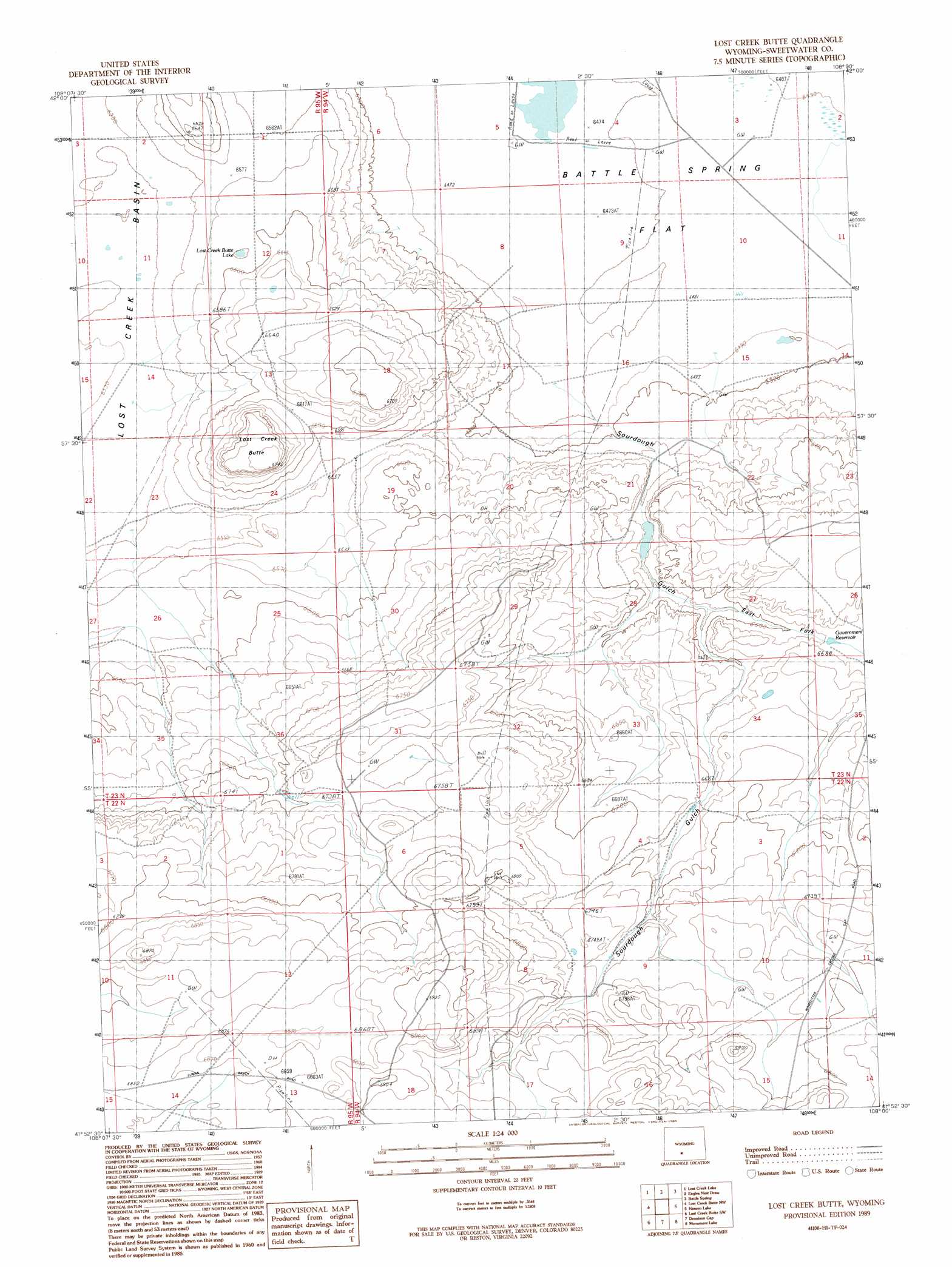
USGS Topo Quad 41108h1 - 1:24,000 scale
| Topo Map Name: | Lost Creek Butte |
| USGS Topo Quad ID: | 41108h1 |
| Print Size: | ca. 21 1/4" wide x 27" high |
| Southeast Coordinates: | 41.875° N latitude / 108° W longitude |
| Map Center Coordinates: | 41.9375° N latitude / 108.0625° W longitude |
| U.S. State: | WY |
| Filename: | o41108h1.jpg |
| Download Map JPG Image: | Lost Creek Butte topo map 1:24,000 scale |
| Map Type: | Topographic |
| Topo Series: | 7.5´ |
| Map Scale: | 1:24,000 |
| Source of Map Images: | United States Geological Survey (USGS) |
| Alternate Map Versions: |
Lost Creek Butte WY 1989, updated 1989 Download PDF Buy paper map Lost Creek Butte WY 2012 Download PDF Buy paper map Lost Creek Butte WY 2015 Download PDF Buy paper map |
1:24,000 Topo Quads surrounding Lost Creek Butte
Five Fingers Butte Ne |
Cyclone Draw |
Osborne Draw |
Antelope Reservoir |
Osborne Well |
Bush Lake |
Lost Creek Lake |
Eagles Nest Draw |
Battle Spring |
Sooner Reservoir |
Red Lake Ne |
Lost Creek Butte Nw |
Lost Creek Butte |
Hansen Lake |
Hansen Lake Ne |
Red Lake Se |
Lost Creek Butte Sw |
Dennison Cap |
Monument Lake |
Ruby Knolls |
Tipton |
Red Desert Nw |
Red Desert |
Wamsutter |
Creston |
> Back to 41108e1 at 1:100,000 scale
> Back to 41108a1 at 1:250,000 scale
> Back to U.S. Topo Maps home
Lost Creek Butte topo map: Gazetteer
Lost Creek Butte: Flats
Battle Spring Flat elevation 1977m 6486′Lost Creek Butte: Lakes
Lost Creek Butte Lake elevation 2007m 6584′Lost Creek Butte: Reservoirs
Government Reservoir elevation 2020m 6627′Lost Creek Butte: Summits
Lost Creek Butte elevation 2042m 6699′Lost Creek Butte: Valleys
East Fork Sourdough Gulch elevation 2021m 6630′Sourdough Gulch elevation 2007m 6584′
Lost Creek Butte digital topo map on disk
Buy this Lost Creek Butte topo map showing relief, roads, GPS coordinates and other geographical features, as a high-resolution digital map file on DVD: