Big Ridge Topo Map Wyoming
To zoom in, hover over the map of Big Ridge
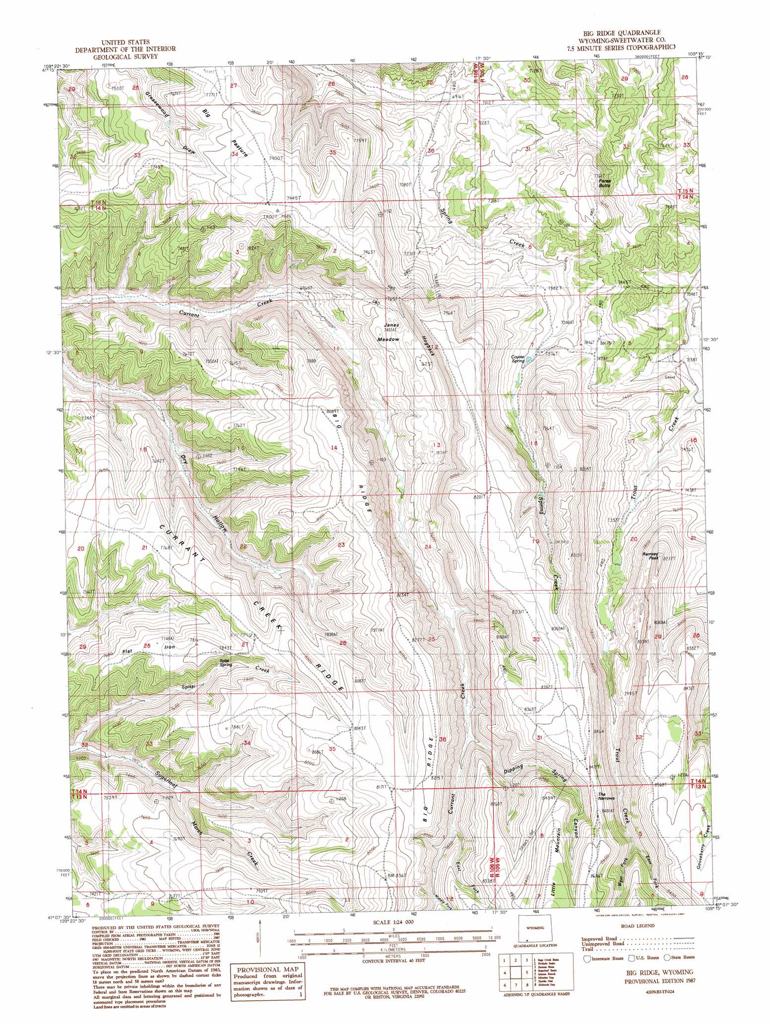
USGS Topo Quad 41109b3 - 1:24,000 scale
| Topo Map Name: | Big Ridge |
| USGS Topo Quad ID: | 41109b3 |
| Print Size: | ca. 21 1/4" wide x 27" high |
| Southeast Coordinates: | 41.125° N latitude / 109.25° W longitude |
| Map Center Coordinates: | 41.1875° N latitude / 109.3125° W longitude |
| U.S. State: | WY |
| Filename: | o41109b3.jpg |
| Download Map JPG Image: | Big Ridge topo map 1:24,000 scale |
| Map Type: | Topographic |
| Topo Series: | 7.5´ |
| Map Scale: | 1:24,000 |
| Source of Map Images: | United States Geological Survey (USGS) |
| Alternate Map Versions: |
Big Ridge WY 1987, updated 1987 Download PDF Buy paper map Big Ridge WY 2012 Download PDF Buy paper map Big Ridge WY 2015 Download PDF Buy paper map |
1:24,000 Topo Quads surrounding Big Ridge
Blacks Fork Bridge |
Whalen Butte |
Wilkins Peak |
Kappes Canyon |
Lion Bluffs |
Halfway Hollow East |
Sage Creek Basin |
Firehole Basin |
Earnest Butte |
South Baxter |
Haystack Buttes North |
Sugarloaf Basin |
Big Ridge |
Maxon Ranch |
Titsworth Gap |
Haystack Buttes South |
Minnies Gap |
Hawks Nest |
Richards Gap |
Red Creek Ranch |
Flaming Gorge |
Dutch John |
Goslin Mountain |
Clay Basin |
Willow Creek Butte |
> Back to 41109a1 at 1:100,000 scale
> Back to 41108a1 at 1:250,000 scale
> Back to U.S. Topo Maps home
Big Ridge topo map: Gazetteer
Big Ridge: Flats
Big Pasture elevation 2404m 7887′Flat Iron elevation 2365m 7759′
Janes Meadow elevation 2296m 7532′
Big Ridge: Gaps
The Narrows elevation 2454m 8051′Big Ridge: Ridges
Big Ridge elevation 2369m 7772′Currant Creek Ridge elevation 2420m 7939′
Big Ridge: Springs
Coyote Spring elevation 2294m 7526′Deer Spring elevation 2367m 7765′
Spitzi Spring elevation 2396m 7860′
Big Ridge: Streams
East Fork Currant Creek elevation 2453m 8047′East Fork Trout Creek elevation 2578m 8458′
Middle Fork Currant Creek elevation 2481m 8139′
Spitzi Creek elevation 2131m 6991′
West Fork Currant Creek elevation 2453m 8047′
West Fork Trout Creek elevation 2578m 8458′
Big Ridge: Summits
Hogback elevation 2442m 8011′Little Mountain elevation 2631m 8631′
Parea Butte elevation 2319m 7608′
Ramsey Peak elevation 2411m 7910′
Big Ridge: Valleys
Dipping Spring Canyon elevation 2432m 7979′Big Ridge digital topo map on disk
Buy this Big Ridge topo map showing relief, roads, GPS coordinates and other geographical features, as a high-resolution digital map file on DVD: