Sugarloaf Basin Topo Map Wyoming
To zoom in, hover over the map of Sugarloaf Basin
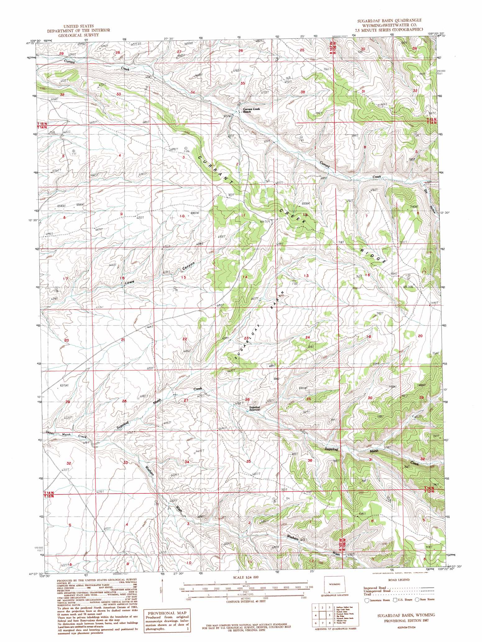
USGS Topo Quad 41109b4 - 1:24,000 scale
| Topo Map Name: | Sugarloaf Basin |
| USGS Topo Quad ID: | 41109b4 |
| Print Size: | ca. 21 1/4" wide x 27" high |
| Southeast Coordinates: | 41.125° N latitude / 109.375° W longitude |
| Map Center Coordinates: | 41.1875° N latitude / 109.4375° W longitude |
| U.S. State: | WY |
| Filename: | o41109b4.jpg |
| Download Map JPG Image: | Sugarloaf Basin topo map 1:24,000 scale |
| Map Type: | Topographic |
| Topo Series: | 7.5´ |
| Map Scale: | 1:24,000 |
| Source of Map Images: | United States Geological Survey (USGS) |
| Alternate Map Versions: |
Sugarloaf Basin WY 1987, updated 1987 Download PDF Buy paper map Sugarloaf Basin WY 2012 Download PDF Buy paper map Sugarloaf Basin WY 2015 Download PDF Buy paper map |
1:24,000 Topo Quads surrounding Sugarloaf Basin
Massacre Hill |
Blacks Fork Bridge |
Whalen Butte |
Wilkins Peak |
Kappes Canyon |
Halfway Hollow West |
Halfway Hollow East |
Sage Creek Basin |
Firehole Basin |
Earnest Butte |
Devils Playground |
Haystack Buttes North |
Sugarloaf Basin |
Big Ridge |
Maxon Ranch |
Linwood Canyon |
Haystack Buttes South |
Minnies Gap |
Hawks Nest |
Richards Gap |
Manila |
Flaming Gorge |
Dutch John |
Goslin Mountain |
Clay Basin |
> Back to 41109a1 at 1:100,000 scale
> Back to 41108a1 at 1:250,000 scale
> Back to U.S. Topo Maps home
Sugarloaf Basin topo map: Gazetteer
Sugarloaf Basin: Basins
Sugarloaf Basin elevation 2065m 6774′Sugarloaf Basin: Reservoirs
Sugarloaf Reservoir elevation 2008m 6587′Sugarloaf Basin: Springs
Washam Spring elevation 1976m 6482′Sugarloaf Basin: Streams
Sugarloaf Marsh Creek elevation 1933m 6341′Sugarloaf Basin: Valleys
Dry Hollow elevation 2049m 6722′Washam Wash elevation 1897m 6223′
Sugarloaf Basin digital topo map on disk
Buy this Sugarloaf Basin topo map showing relief, roads, GPS coordinates and other geographical features, as a high-resolution digital map file on DVD: