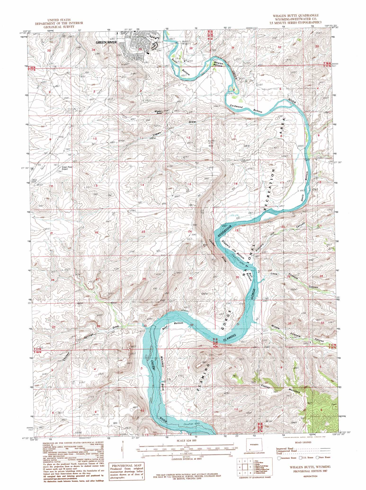
Whalen Butte Topo Map Wyoming
To zoom in, hover over the map of Whalen Butte
USGS Topo Quad 41109d4 - 1:24,000 scale
| Topo Map Name: | Whalen Butte |
| USGS Topo Quad ID: | 41109d4 |
| Print Size: | ca. 21 1/4" wide x 27" high |
| Southeast Coordinates: | 41.375° N latitude / 109.375° W longitude |
| Map Center Coordinates: | 41.4375° N latitude / 109.4375° W longitude |
| U.S. State: | WY |
| Filename: | o41109d4.jpg |
| Download Map JPG Image: | Whalen Butte topo map 1:24,000 scale |
| Map Type: | Topographic |
| Topo Series: | 7.5´ |
| Map Scale: | 1:24,000 |
| Source of Map Images: | United States Geological Survey (USGS) |
| Alternate Map Versions: |
Whalen Butte WY 1987, updated 1987 Download PDF Buy paper map Whalen Butte WY 1996, updated 1999 Download PDF Buy paper map Whalen Butte WY 2012 Download PDF Buy paper map Whalen Butte WY 2015 Download PDF Buy paper map |
| FStopo: | US Forest Service topo Whalen Butte is available: Download FStopo PDF Download FStopo TIF |
1:24,000 Topo Quads surrounding Whalen Butte
Stevens Flat |
Austin Ranch |
Scott Spring |
Pilot Butte |
Reliance |
Bryan |
Peru |
Green River |
Kanda |
Rock Springs |
Massacre Hill |
Blacks Fork Bridge |
Whalen Butte |
Wilkins Peak |
Kappes Canyon |
Halfway Hollow West |
Halfway Hollow East |
Sage Creek Basin |
Firehole Basin |
Earnest Butte |
Devils Playground |
Haystack Buttes North |
Sugarloaf Basin |
Big Ridge |
Maxon Ranch |
> Back to 41109a1 at 1:100,000 scale
> Back to 41108a1 at 1:250,000 scale
> Back to U.S. Topo Maps home
Whalen Butte topo map: Gazetteer
Whalen Butte: Airports
Green River Airport elevation 2189m 7181′Whalen Butte: Bends
Boat Bottom elevation 1848m 6062′Cordwood Bottom elevation 1851m 6072′
Davis Bottom elevation 1849m 6066′
Scott Bottom elevation 1847m 6059′
Whalen Bottom elevation 1853m 6079′
Whiskey Bend elevation 1842m 6043′
Whalen Butte: Summits
Whalen Butte elevation 2087m 6847′Whalen Butte: Valleys
Chicke Springs Draw elevation 1842m 6043′Laney Wash elevation 2021m 6630′
Little Firehole Canyon elevation 1843m 6046′
Logan Draw elevation 1849m 6066′
Middle Firehole Canyon elevation 1845m 6053′
Slippery Jim Canyon elevation 1849m 6066′
Whalen Butte digital topo map on disk
Buy this Whalen Butte topo map showing relief, roads, GPS coordinates and other geographical features, as a high-resolution digital map file on DVD: