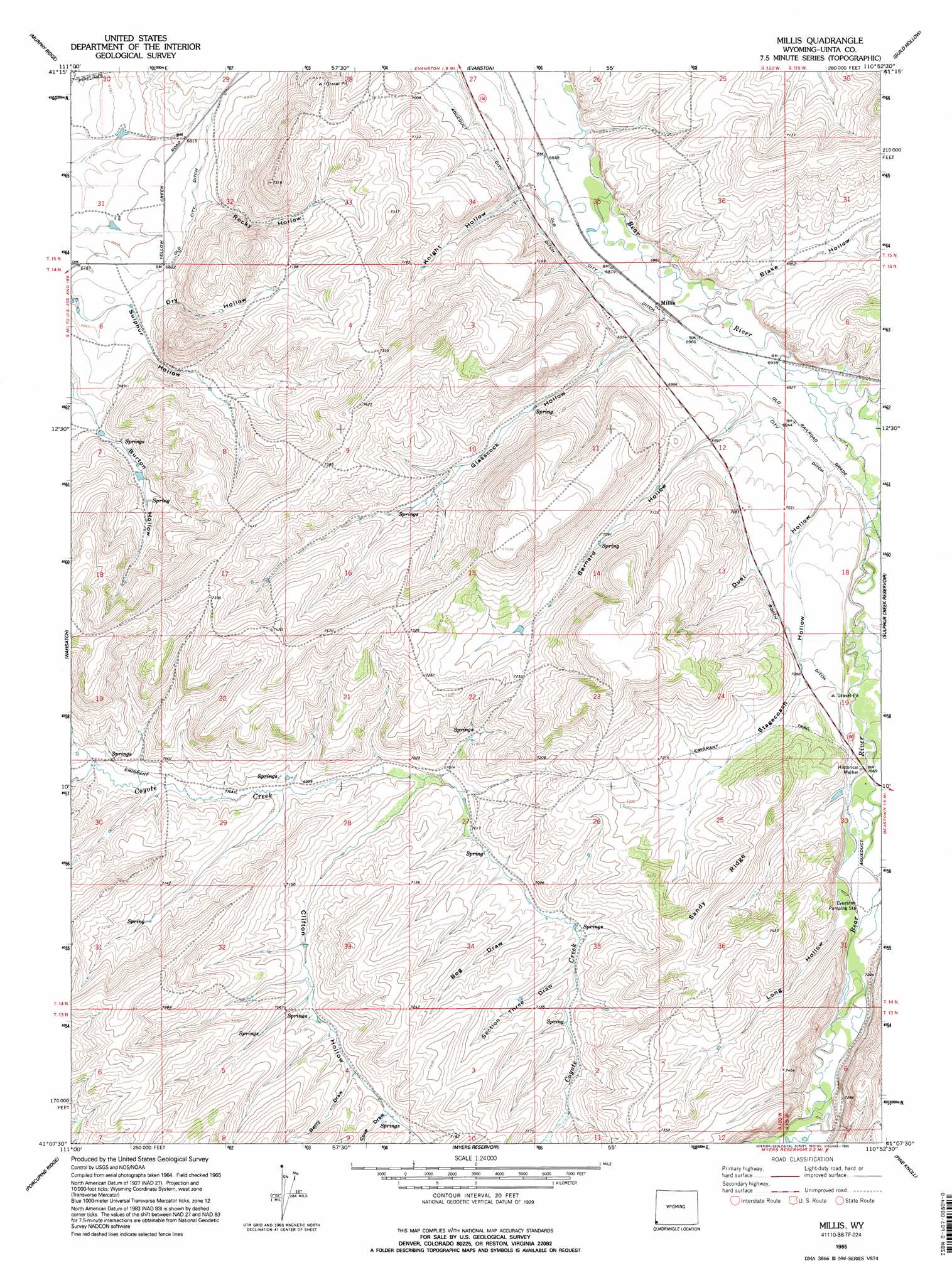
Millis Topo Map Wyoming
To zoom in, hover over the map of Millis
USGS Topo Quad 41110b8 - 1:24,000 scale
| Topo Map Name: | Millis |
| USGS Topo Quad ID: | 41110b8 |
| Print Size: | ca. 21 1/4" wide x 27" high |
| Southeast Coordinates: | 41.125° N latitude / 110.875° W longitude |
| Map Center Coordinates: | 41.1875° N latitude / 110.9375° W longitude |
| U.S. State: | WY |
| Filename: | o41110b8.jpg |
| Download Map JPG Image: | Millis topo map 1:24,000 scale |
| Map Type: | Topographic |
| Topo Series: | 7.5´ |
| Map Scale: | 1:24,000 |
| Source of Map Images: | United States Geological Survey (USGS) |
| Alternate Map Versions: |
Millis WY 1965, updated 1968 Download PDF Buy paper map Millis WY 1965, updated 1995 Download PDF Buy paper map Millis WY 2012 Download PDF Buy paper map Millis WY 2015 Download PDF Buy paper map |
1:24,000 Topo Quads surrounding Millis
Neponset Reservoir Nw |
Neponset Reservoir Ne |
Three Forks |
Little Dee Creek |
Meadow Draw |
Mckay Hollow |
Murphy Ridge |
Evanston |
Guild Hollow |
Ragan |
Shearing Corral |
Wahsatch |
Millis |
Sulphur Creek Reservoir |
Piedmont Reservoir |
Castle Rock |
Porcupine Ridge |
Myers Reservoir |
Pine Knoll |
Moslander Reservoir |
Upton |
Red Hole |
Seven Tree Flat |
Deadman Mountain |
Elizabeth Mountain |
> Back to 41110a1 at 1:100,000 scale
> Back to 41110a1 at 1:250,000 scale
> Back to U.S. Topo Maps home
Millis topo map: Gazetteer
Millis: Dams
East Dam elevation 2092m 6863′Millis: Mines
Jamison Claim elevation 2160m 7086′Millis: Reservoirs
East Reservoir elevation 2092m 6863′Millis: Ridges
Sandy Ridge elevation 2245m 7365′Millis: Streams
Spring Creek elevation 2191m 7188′Stowe Creek elevation 2118m 6948′
Millis: Trails
Emigrant Trail elevation 2125m 6971′Millis: Valleys
Bernard Hollow elevation 2114m 6935′Berry Draw elevation 2159m 7083′
Blake Hollow elevation 2103m 6899′
Bog Draw elevation 2151m 7057′
Clifton Hollow elevation 2132m 6994′
Cove Draw elevation 2168m 7112′
Dry Hollow elevation 2086m 6843′
Duel Hollow elevation 2129m 6984′
Glasscock Hollow elevation 2106m 6909′
Knight Hollow elevation 2094m 6870′
Long Hollow elevation 2169m 7116′
Meadow Draw elevation 2171m 7122′
Rocky Hollow elevation 2090m 6856′
Section Three Draw elevation 2156m 7073′
Stagecoach Hollow elevation 2146m 7040′
Millis digital topo map on disk
Buy this Millis topo map showing relief, roads, GPS coordinates and other geographical features, as a high-resolution digital map file on DVD: