Bell Butte Topo Map Wyoming
To zoom in, hover over the map of Bell Butte
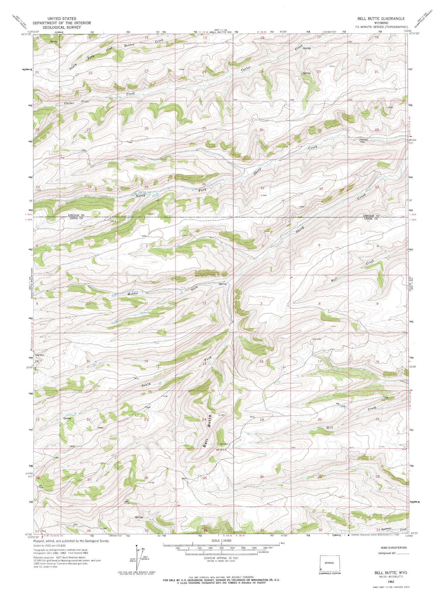
USGS Topo Quad 41110e7 - 1:24,000 scale
| Topo Map Name: | Bell Butte |
| USGS Topo Quad ID: | 41110e7 |
| Print Size: | ca. 21 1/4" wide x 27" high |
| Southeast Coordinates: | 41.5° N latitude / 110.75° W longitude |
| Map Center Coordinates: | 41.5625° N latitude / 110.8125° W longitude |
| U.S. State: | WY |
| Filename: | o41110e7.jpg |
| Download Map JPG Image: | Bell Butte topo map 1:24,000 scale |
| Map Type: | Topographic |
| Topo Series: | 7.5´ |
| Map Scale: | 1:24,000 |
| Source of Map Images: | United States Geological Survey (USGS) |
| Alternate Map Versions: |
Bell Butte WY 1962, updated 1965 Download PDF Buy paper map Bell Butte WY 2012 Download PDF Buy paper map Bell Butte WY 2015 Download PDF Buy paper map |
1:24,000 Topo Quads surrounding Bell Butte
Leefe |
Sage |
Nugget |
Fossil |
Kemmerer |
Rex Peak |
Windy Point |
Bell Butte Ne |
Warfield Creek |
Elkol |
Woodruff Narrows |
Sawtooth Mountain |
Bell Butte |
Elkol Sw |
Cumberland Gap |
Neponset Reservoir Ne |
Three Forks |
Little Dee Creek |
Meadow Draw |
Bridger |
Murphy Ridge |
Evanston |
Guild Hollow |
Ragan |
Leroy |
> Back to 41110e1 at 1:100,000 scale
> Back to 41110a1 at 1:250,000 scale
> Back to U.S. Topo Maps home
Bell Butte topo map: Gazetteer
Bell Butte: Streams
Middle Fork Sheep Creek elevation 2147m 7043′South Fork Sheep Creek elevation 2147m 7043′
Bell Butte: Summits
Bell Butte elevation 2430m 7972′Bell Butte digital topo map on disk
Buy this Bell Butte topo map showing relief, roads, GPS coordinates and other geographical features, as a high-resolution digital map file on DVD: