Lost Creek Dam Topo Map Utah
To zoom in, hover over the map of Lost Creek Dam
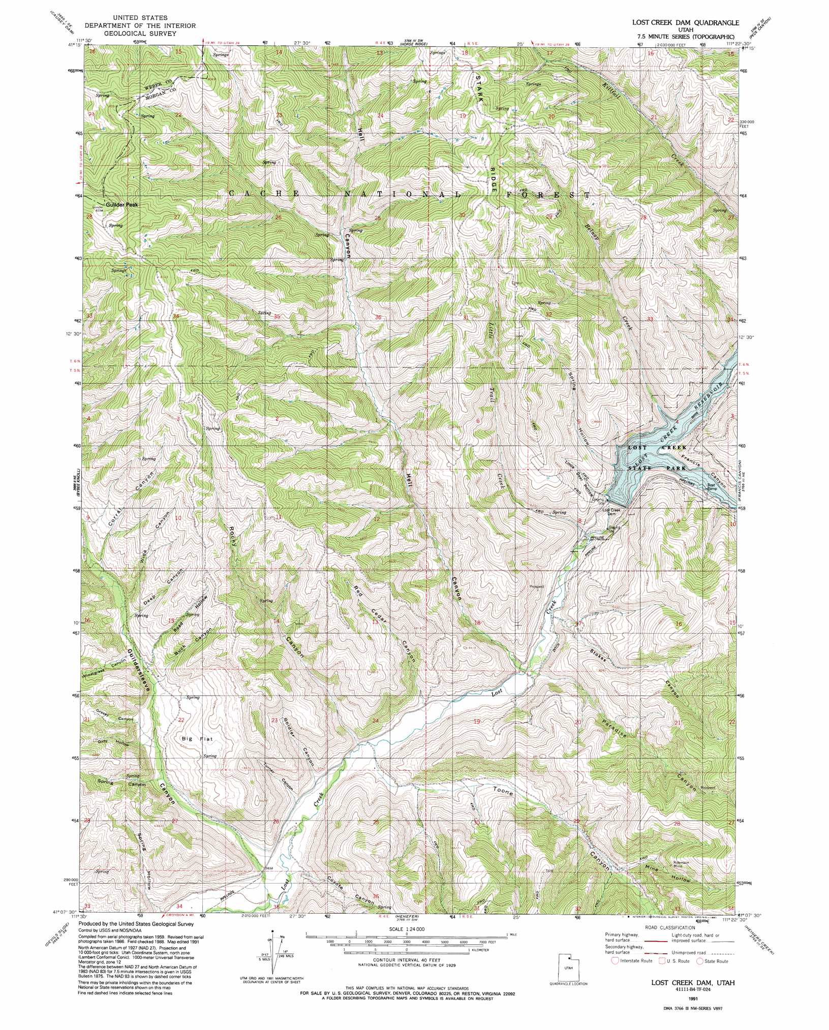
USGS Topo Quad 41111b4 - 1:24,000 scale
| Topo Map Name: | Lost Creek Dam |
| USGS Topo Quad ID: | 41111b4 |
| Print Size: | ca. 21 1/4" wide x 27" high |
| Southeast Coordinates: | 41.125° N latitude / 111.375° W longitude |
| Map Center Coordinates: | 41.1875° N latitude / 111.4375° W longitude |
| U.S. State: | UT |
| Filename: | o41111b4.jpg |
| Download Map JPG Image: | Lost Creek Dam topo map 1:24,000 scale |
| Map Type: | Topographic |
| Topo Series: | 7.5´ |
| Map Scale: | 1:24,000 |
| Source of Map Images: | United States Geological Survey (USGS) |
| Alternate Map Versions: |
Lost Creek Dam UT 1964 Download PDF Buy paper map Lost Creek Dam UT 1964, updated 1986 Download PDF Buy paper map Lost Creek Dam UT 1991, updated 1991 Download PDF Buy paper map Lost Creek Dam UT 1998, updated 2000 Download PDF Buy paper map Lost Creek Dam UT 2011 Download PDF Buy paper map Lost Creek Dam UT 2014 Download PDF Buy paper map |
| FStopo: | US Forest Service topo Lost Creek Dam is available: Download FStopo PDF Download FStopo TIF |
1:24,000 Topo Quads surrounding Lost Creek Dam
Sharp Mountain |
Monte Cristo Peak |
Dairy Ridge |
Meachum Ridge |
Neponset Reservoir Nw |
Browns Hole |
Causey Dam |
Horse Ridge |
Peck Canyon |
Mckay Hollow |
Durst Mountain |
Bybee Knoll |
Lost Creek Dam |
Francis Canyon |
Shearing Corral |
Morgan |
Devils Slide |
Henefer |
Heiners Creek |
Castle Rock |
Porterville |
East Canyon Reservoir |
Coalville |
Turner Hollow |
Upton |
> Back to 41111a1 at 1:100,000 scale
> Back to 41110a1 at 1:250,000 scale
> Back to U.S. Topo Maps home
Lost Creek Dam topo map: Gazetteer
Lost Creek Dam: Dams
Lost Creek Dam elevation 1836m 6023′Lost Creek Dam: Flats
Big Flat elevation 1912m 6272′Lost Creek Dam: Forests
Wasatch-Cache National Forest elevation 2416m 7926′Lost Creek Dam: Mines
Robinson Mine elevation 2120m 6955′Lost Creek Dam: Parks
Lost Creek State Park elevation 1847m 6059′Lost Creek Dam: Reservoirs
Lost Creek Reservoir elevation 1833m 6013′Lost Creek Dam: Streams
Belnap Creek elevation 1832m 6010′Little Trail Creek elevation 1776m 5826′
Lost Creek Dam: Summits
Guilder Peak elevation 2532m 8307′Lost Creek Dam: Valleys
Buck Canyon elevation 1866m 6122′Corral Canyon elevation 1935m 6348′
Coyote Canyon elevation 1727m 5666′
Deep Canyon elevation 1899m 6230′
Dirty Hollow elevation 1850m 6069′
Francis Canyon elevation 1832m 6010′
Grassy Canyon elevation 1867m 6125′
Guildersleeve Canyon elevation 1725m 5659′
Hell Canyon elevation 1756m 5761′
Little Deer Hollow elevation 1832m 6010′
Mine Hollow elevation 1984m 6509′
Paradise Canyon elevation 1766m 5793′
Red Cedar Canyon elevation 1752m 5748′
Road Hollow elevation 1874m 6148′
Rocky Canyon elevation 1735m 5692′
Soldier Canyon elevation 1745m 5725′
Spring Canyon elevation 1817m 5961′
Spring Hollow elevation 1851m 6072′
Stokes Canyon elevation 1777m 5830′
Toone Canyon elevation 1745m 5725′
Turner Canyon elevation 1744m 5721′
Wheatgrass Canyon elevation 1894m 6213′
Wide Canyon elevation 1915m 6282′
Lost Creek Dam digital topo map on disk
Buy this Lost Creek Dam topo map showing relief, roads, GPS coordinates and other geographical features, as a high-resolution digital map file on DVD: