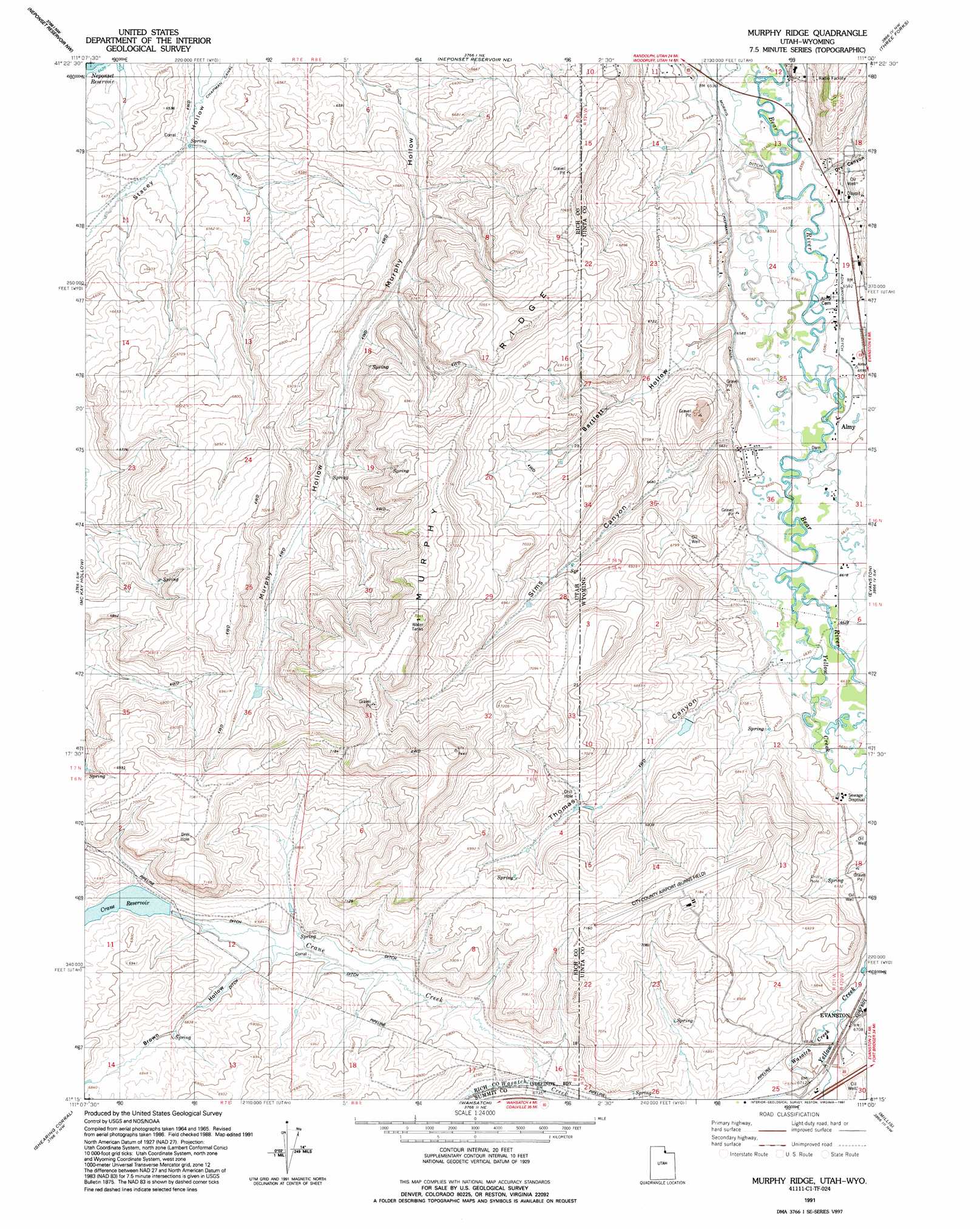
Murphy Ridge Topo Map Utah
To zoom in, hover over the map of Murphy Ridge
USGS Topo Quad 41111c1 - 1:24,000 scale
| Topo Map Name: | Murphy Ridge |
| USGS Topo Quad ID: | 41111c1 |
| Print Size: | ca. 21 1/4" wide x 27" high |
| Southeast Coordinates: | 41.25° N latitude / 111° W longitude |
| Map Center Coordinates: | 41.3125° N latitude / 111.0625° W longitude |
| U.S. States: | UT, WY |
| Filename: | o41111c1.jpg |
| Download Map JPG Image: | Murphy Ridge topo map 1:24,000 scale |
| Map Type: | Topographic |
| Topo Series: | 7.5´ |
| Map Scale: | 1:24,000 |
| Source of Map Images: | United States Geological Survey (USGS) |
| Alternate Map Versions: |
Murphy Ridge UT 1968, updated 1971 Download PDF Buy paper map Murphy Ridge UT 1968, updated 1981 Download PDF Buy paper map Murphy Ridge UT 1991, updated 1991 Download PDF Buy paper map Murphy Ridge UT 2010 Download PDF Buy paper map Murphy Ridge UT 2014 Download PDF Buy paper map |
1:24,000 Topo Quads surrounding Murphy Ridge
Birch Creek Reservoirs |
Woodruff |
Woodruff Narrows |
Sawtooth Mountain |
Bell Butte |
Meachum Ridge |
Neponset Reservoir Nw |
Neponset Reservoir Ne |
Three Forks |
Little Dee Creek |
Peck Canyon |
Mckay Hollow |
Murphy Ridge |
Evanston |
Guild Hollow |
Francis Canyon |
Shearing Corral |
Wahsatch |
Millis |
Sulphur Creek Reservoir |
Heiners Creek |
Castle Rock |
Porcupine Ridge |
Myers Reservoir |
Pine Knoll |
> Back to 41111a1 at 1:100,000 scale
> Back to 41110a1 at 1:250,000 scale
> Back to U.S. Topo Maps home
Murphy Ridge topo map: Gazetteer
Murphy Ridge: Airports
Evanston-Uinta County Burns Field elevation 2175m 7135′Murphy Ridge: Canals
Adin Brown Ditch elevation 2007m 6584′Morris Ditch elevation 1995m 6545′
Murphy Ridge: Dams
Chesney Dam elevation 2059m 6755′Murphy Ridge: Mines
Almy Number Seven Mine elevation 2020m 6627′Almy Number Six Mine elevation 2014m 6607′
Murphy Ridge: Populated Places
Almy elevation 2008m 6587′Murphy Ridge: Reservoirs
Chesney Reservoir elevation 2059m 6755′Crane Reservoir elevation 2074m 6804′
Murphy Ridge: Ridges
Murphy Ridge elevation 2172m 7125′Murphy Ridge: Streams
Crane Creek elevation 2051m 6729′Red Canyon Creek elevation 2014m 6607′
Wasatch Creek elevation 2044m 6706′
Wasatch Creek elevation 2042m 6699′
Yellow Creek elevation 2018m 6620′
Yellow Creek elevation 2018m 6620′
Murphy Ridge: Valleys
Bartlett Hollow elevation 2007m 6584′Bartlett Hollow elevation 2007m 6584′
Brown Hollow elevation 2073m 6801′
Dry Canyon elevation 2007m 6584′
Sims Canyon elevation 2014m 6607′
Sims Canyon elevation 2015m 6610′
Thomas Canyon elevation 2022m 6633′
Thomas Canyon elevation 2022m 6633′
Murphy Ridge digital topo map on disk
Buy this Murphy Ridge topo map showing relief, roads, GPS coordinates and other geographical features, as a high-resolution digital map file on DVD: