Mckay Hollow Topo Map Utah
To zoom in, hover over the map of Mckay Hollow
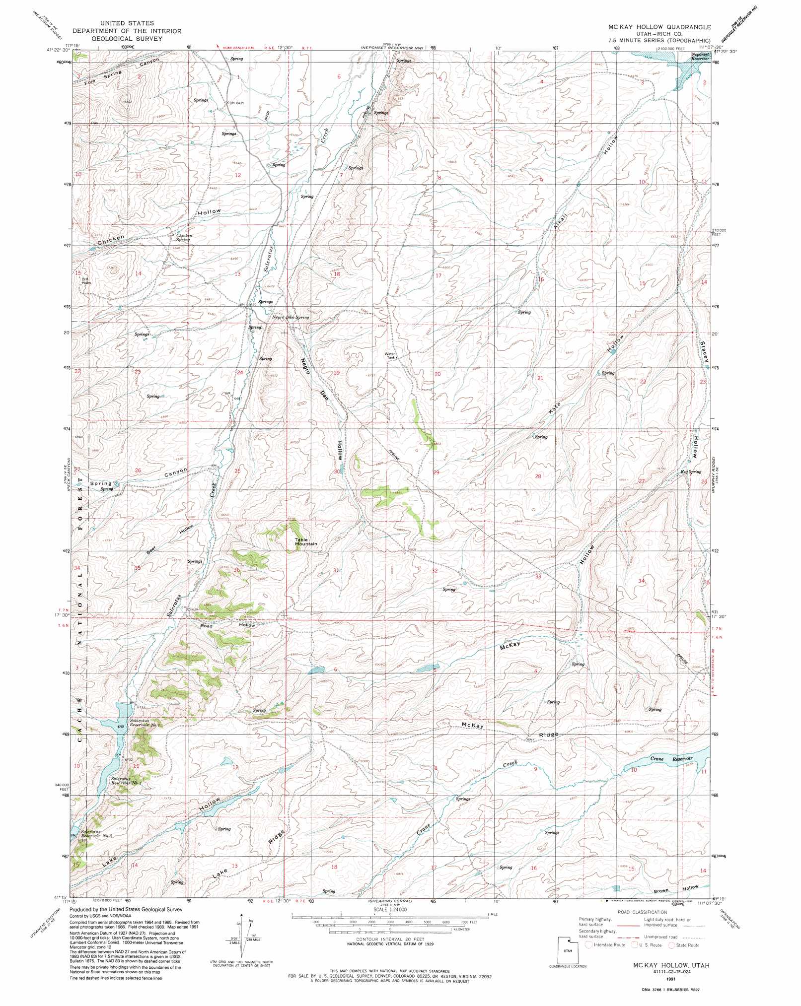
USGS Topo Quad 41111c2 - 1:24,000 scale
| Topo Map Name: | Mckay Hollow |
| USGS Topo Quad ID: | 41111c2 |
| Print Size: | ca. 21 1/4" wide x 27" high |
| Southeast Coordinates: | 41.25° N latitude / 111.125° W longitude |
| Map Center Coordinates: | 41.3125° N latitude / 111.1875° W longitude |
| U.S. State: | UT |
| Filename: | o41111c2.jpg |
| Download Map JPG Image: | Mckay Hollow topo map 1:24,000 scale |
| Map Type: | Topographic |
| Topo Series: | 7.5´ |
| Map Scale: | 1:24,000 |
| Source of Map Images: | United States Geological Survey (USGS) |
| Alternate Map Versions: |
Mc Kay Hollow UT 1968, updated 1971 Download PDF Buy paper map Mc Kay Hollow UT 1968, updated 1986 Download PDF Buy paper map Mc Kay Hollow UT 1991, updated 1991 Download PDF Buy paper map Mc Kay Hollow UT 1998, updated 2001 Download PDF Buy paper map McKay Hollow UT 2011 Download PDF Buy paper map McKay Hollow UT 2014 Download PDF Buy paper map |
| FStopo: | US Forest Service topo McKay Hollow is available: Download FStopo PDF Download FStopo TIF |
1:24,000 Topo Quads surrounding Mckay Hollow
Curtis Ridge |
Birch Creek Reservoirs |
Woodruff |
Woodruff Narrows |
Sawtooth Mountain |
Dairy Ridge |
Meachum Ridge |
Neponset Reservoir Nw |
Neponset Reservoir Ne |
Three Forks |
Horse Ridge |
Peck Canyon |
Mckay Hollow |
Murphy Ridge |
Evanston |
Lost Creek Dam |
Francis Canyon |
Shearing Corral |
Wahsatch |
Millis |
Henefer |
Heiners Creek |
Castle Rock |
Porcupine Ridge |
Myers Reservoir |
> Back to 41111a1 at 1:100,000 scale
> Back to 41110a1 at 1:250,000 scale
> Back to U.S. Topo Maps home
Mckay Hollow topo map: Gazetteer
Mckay Hollow: Reservoirs
Saleratus Reservoir Number 1 elevation 2044m 6706′Saleratus Reservoir Number 2 elevation 2045m 6709′
Saleratus Reservoir Number 3 elevation 2058m 6751′
Mckay Hollow: Ridges
Lake Ridge elevation 2204m 7230′McKay Ridge elevation 2116m 6942′
Mckay Hollow: Springs
Chicken Spring elevation 1981m 6499′Keg Spring elevation 2010m 6594′
Negro Dan Spring elevation 1970m 6463′
Mckay Hollow: Streams
Spring Creek elevation 1986m 6515′Mckay Hollow: Summits
Table Mountain elevation 2147m 7043′Mckay Hollow: Valleys
Alkali Hollow elevation 1959m 6427′Beer Hollow elevation 1999m 6558′
Chicken Hollow elevation 1962m 6437′
Five Spring Canyon elevation 1982m 6502′
Kate Hollow elevation 1985m 6512′
McKay Hollow elevation 2009m 6591′
Negro Dan Hollow elevation 1967m 6453′
Road Hollow elevation 2024m 6640′
Spring Canyon elevation 1987m 6519′
Spring Canyon elevation 1985m 6512′
Mckay Hollow digital topo map on disk
Buy this Mckay Hollow topo map showing relief, roads, GPS coordinates and other geographical features, as a high-resolution digital map file on DVD: