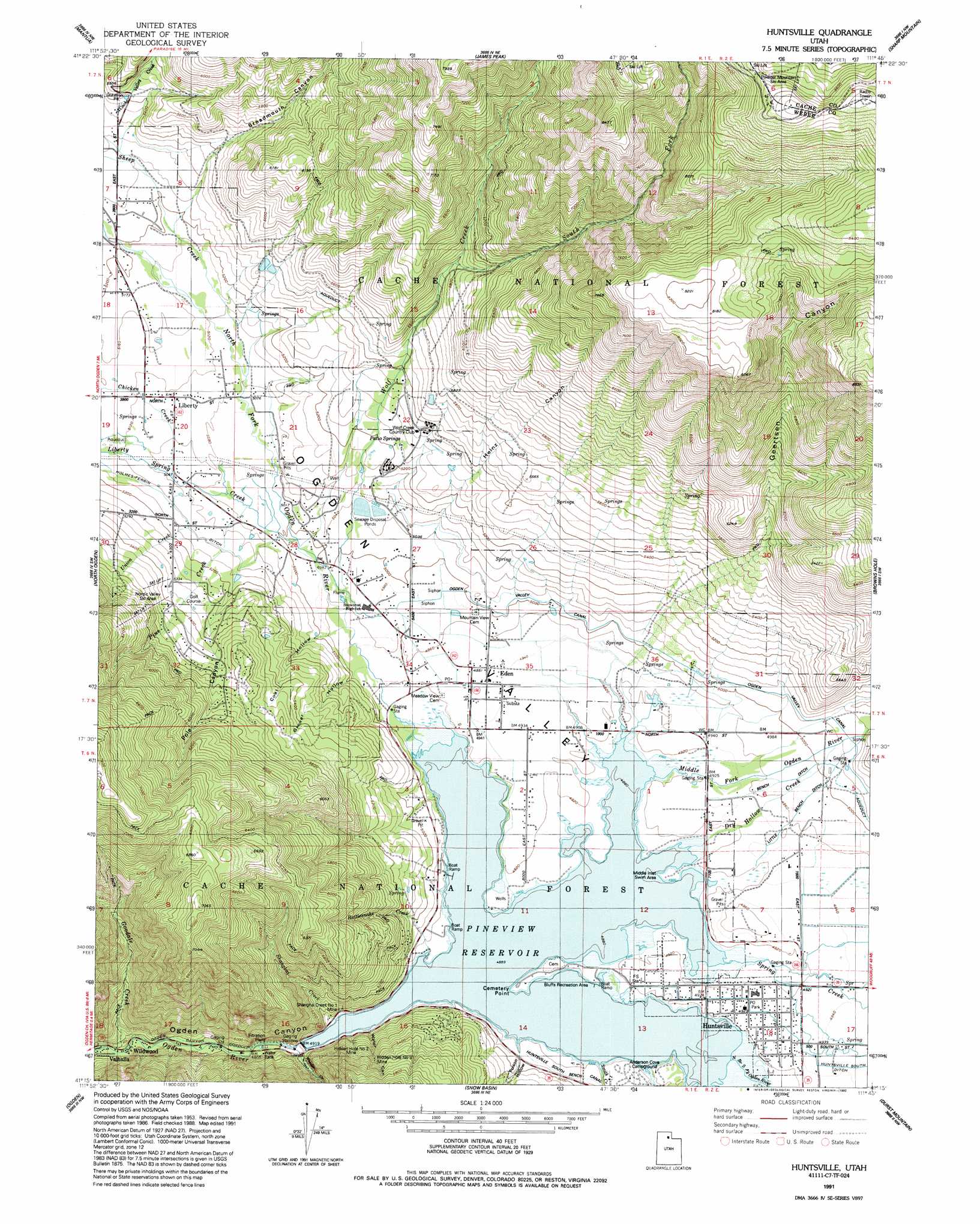
Huntsville Topo Map Utah
To zoom in, hover over the map of Huntsville
USGS Topo Quad 41111c7 - 1:24,000 scale
| Topo Map Name: | Huntsville |
| USGS Topo Quad ID: | 41111c7 |
| Print Size: | ca. 21 1/4" wide x 27" high |
| Southeast Coordinates: | 41.25° N latitude / 111.75° W longitude |
| Map Center Coordinates: | 41.3125° N latitude / 111.8125° W longitude |
| U.S. State: | UT |
| Filename: | o41111c7.jpg |
| Download Map JPG Image: | Huntsville topo map 1:24,000 scale |
| Map Type: | Topographic |
| Topo Series: | 7.5´ |
| Map Scale: | 1:24,000 |
| Source of Map Images: | United States Geological Survey (USGS) |
| Alternate Map Versions: |
Huntsville UT 1955, updated 1956 Download PDF Buy paper map Huntsville UT 1955, updated 1963 Download PDF Buy paper map Huntsville UT 1955, updated 1978 Download PDF Buy paper map Huntsville UT 1955, updated 1988 Download PDF Buy paper map Huntsville UT 1991, updated 1992 Download PDF Buy paper map Huntsville UT 1998, updated 2001 Download PDF Buy paper map Huntsville UT 2011 Download PDF Buy paper map Huntsville UT 2014 Download PDF Buy paper map |
| FStopo: | US Forest Service topo Huntsville is available: Download FStopo PDF Download FStopo TIF |
1:24,000 Topo Quads surrounding Huntsville
Brigham City |
Mount Pisgah |
Paradise |
Porcupine Reservoir |
Hardware Ranch |
Willard |
Mantua |
James Peak |
Sharp Mountain |
Monte Cristo Peak |
Plain City |
North Ogden |
Huntsville |
Browns Hole |
Causey Dam |
Roy |
Ogden |
Snow Basin |
Durst Mountain |
Bybee Knoll |
Clearfield |
Kaysville |
Peterson |
Morgan |
Devils Slide |
> Back to 41111a1 at 1:100,000 scale
> Back to 41110a1 at 1:250,000 scale
> Back to U.S. Topo Maps home
Huntsville topo map: Gazetteer
Huntsville: Airports
Powder Mountain Ski Area Heliport elevation 2568m 8425′Huntsville: Canals
Bench Ditch elevation 1514m 4967′Holmes-Ferrin Ditch elevation 1564m 5131′
Little Bench Ditch elevation 1514m 4967′
Ogden Canyon Conduit elevation 1455m 4773′
Huntsville: Mines
Hidden Hole Number 2 Mine elevation 1517m 4977′Hidden Hole Number 3 Mine elevation 1641m 5383′
Shanghai Creek Number 1 Mine elevation 1527m 5009′
Huntsville: Populated Places
Big Sky Estates elevation 1721m 5646′Blake Holley elevation 1633m 5357′
Casey Acres elevation 1501m 4924′
Eden elevation 1508m 4947′
Eden Hills elevation 1538m 5045′
Eden Meadows elevation 1518m 4980′
Eden Village elevation 1506m 4940′
Gardens of Eden elevation 1506m 4940′
Huntsville elevation 1502m 4927′
Idlewild Townsite elevation 1460m 4790′
Liberty elevation 1560m 5118′
Liberty Bell Ranchettes elevation 1594m 5229′
Liberty Meadows elevation 1555m 5101′
Middle Fork Ranches elevation 1508m 4947′
Minnie Creek Estates elevation 1501m 4924′
Mountain View Estates elevation 1521m 4990′
Nordic Valley Estates elevation 1624m 5328′
North Fork Estates elevation 1562m 5124′
Ogden Canyon Wildwood Estates elevation 1465m 4806′
Patio Springs elevation 1572m 5157′
Pine View Park elevation 1491m 4891′
Pine View West elevation 1524m 5000′
Robins Roost elevation 1508m 4947′
Shannon Bee Estates elevation 1604m 5262′
Silver Bell Estates elevation 1675m 5495′
Ski/Lake Village Condominium elevation 1502m 4927′
Spurlock elevation 1637m 5370′
Wildwood elevation 1449m 4753′
Willow Creek elevation 1584m 5196′
Wolf Creek elevation 1626m 5334′
Wolf Creek Village elevation 1610m 5282′
Wolf Lodge Condominium elevation 1574m 5164′
Wolf Star elevation 1658m 5439′
Huntsville: Post Offices
Eden Post Office elevation 1507m 4944′Huntsville Post Office elevation 1503m 4931′
Huntsville: Reservoirs
Pineview Reservoir elevation 1491m 4891′Huntsville: Springs
Patio Springs elevation 1606m 5269′Huntsville: Streams
Cache Valley Creek elevation 1628m 5341′Chicken Creek elevation 1548m 5078′
Dry Hollow Creek elevation 1500m 4921′
Gertsen Creek elevation 1499m 4917′
Goodale Creek elevation 1463m 4799′
Liberty Spring Creek elevation 1523m 4996′
Middle Fork Ogden River elevation 1500m 4921′
North Branch South Fork Ogden River elevation 1496m 4908′
North Fork Ogden River elevation 1494m 4901′
Pine Creek elevation 1535m 5036′
Rattlesnake Creek elevation 1491m 4891′
Shanghai Creek elevation 1495m 4904′
Sheep Creek elevation 1551m 5088′
Smith Creek elevation 1491m 4891′
South Fork Wolf Creek elevation 1765m 5790′
Spring Creek elevation 1497m 4911′
Union Creek elevation 1561m 5121′
Wheeler Creek elevation 1464m 4803′
Wolf Creek elevation 1512m 4960′
Huntsville: Valleys
Broadmouth Canyon elevation 1598m 5242′Coal Hollow elevation 1512m 4960′
Geertsen Canyon elevation 1759m 5770′
Grover Hollow elevation 1508m 4947′
Heinz Canyon elevation 1550m 5085′
Ogden Valley elevation 1491m 4891′
Poison Hollow elevation 1513m 4963′
Pole Canyon elevation 1555m 5101′
Water Canyon elevation 1501m 4924′
Huntsville digital topo map on disk
Buy this Huntsville topo map showing relief, roads, GPS coordinates and other geographical features, as a high-resolution digital map file on DVD: