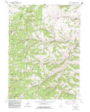
Dairy Ridge Topo Map Utah
To zoom in, hover over the map of Dairy Ridge
USGS Topo Quad 41111d4 - 1:24,000 scale
| Topo Map Name: | Dairy Ridge |
| USGS Topo Quad ID: | 41111d4 |
| Print Size: | ca. 21 1/4" wide x 27" high |
| Southeast Coordinates: | 41.375° N latitude / 111.375° W longitude |
| Map Center Coordinates: | 41.4375° N latitude / 111.4375° W longitude |
| U.S. State: | UT |
| Filename: | o41111d4.jpg |
| Download Map JPG Image: | Dairy Ridge topo map 1:24,000 scale |
| Map Type: | Topographic |
| Topo Series: | 7.5´ |
| Map Scale: | 1:24,000 |
| Source of Map Images: | United States Geological Survey (USGS) |
| Alternate Map Versions: |
Dairy Ridge UT 1968, updated 1970 Download PDF Buy paper map Dairy Ridge UT 1968, updated 1971 Download PDF Buy paper map Dairy Ridge UT 1968, updated 1986 Download PDF Buy paper map Dairy Ridge UT 1991, updated 1991 Download PDF Buy paper map Dairy Ridge UT 1998, updated 2001 Download PDF Buy paper map Dairy Ridge UT 2011 Download PDF Buy paper map Dairy Ridge UT 2014 Download PDF Buy paper map |
| FStopo: | US Forest Service topo Dairy Ridge is available: Download FStopo PDF Download FStopo TIF |
1:24,000 Topo Quads surrounding Dairy Ridge
> Back to 41111a1 at 1:100,000 scale
> Back to 41110a1 at 1:250,000 scale
> Back to U.S. Topo Maps home
Dairy Ridge topo map: Gazetteer
Dairy Ridge: Reservoirs
Dairy Ridge Reservoir elevation 2426m 7959′Dairy Ridge: Ridges
Baldy Ridge elevation 2526m 8287′Cave Ridge elevation 2471m 8106′
Dairy Ridge elevation 2468m 8097′
Eli Ridge elevation 2671m 8763′
Middle Ridge elevation 2578m 8458′
Swan Ridge elevation 2525m 8284′
Dairy Ridge: Springs
Banks Spring elevation 2431m 7975′Big Spring elevation 2472m 8110′
Bluff Spring elevation 2649m 8690′
Bountiful Spring elevation 2472m 8110′
Byram Spring elevation 2639m 8658′
Cave Spring elevation 2367m 7765′
Choke Spring elevation 2482m 8143′
Davenport Spring elevation 2672m 8766′
Desert Spring elevation 2479m 8133′
Freds Spring elevation 2615m 8579′
Front Hollow Spring elevation 2521m 8270′
Hatch Spring elevation 2472m 8110′
Indian Spring elevation 2662m 8733′
Limestone Spring elevation 2707m 8881′
Millie Spring elevation 2358m 7736′
Neponset Spring elevation 2621m 8599′
Open Spring elevation 2398m 7867′
Peggy Hollow Spring elevation 2323m 7621′
Petes Spring elevation 2348m 7703′
Phosphate Spring elevation 2288m 7506′
Pipe Spring elevation 2484m 8149′
Ranger Spring elevation 2499m 8198′
Red Rock Spring elevation 2532m 8307′
Southwick Spring elevation 2522m 8274′
Sprout Spring elevation 2669m 8756′
Sugar Pine Spring elevation 2292m 7519′
Swan Spring elevation 2496m 8188′
Wheatgrass Spring elevation 2484m 8149′
Wheeler Spring elevation 2361m 7746′
William Spring elevation 2423m 7949′
Dairy Ridge: Streams
Big Spring Fork elevation 2208m 7244′Wheeler Creek elevation 2170m 7119′
Dairy Ridge: Summits
Baldy Peak elevation 2637m 8651′Eccles Peak elevation 2757m 9045′
Dairy Ridge: Valleys
Dip Hollow elevation 2315m 7595′Freds Hollow elevation 2489m 8166′
Girl Hollow elevation 2322m 7618′
Hansen Canyon elevation 2346m 7696′
Peggy Hollow elevation 2284m 7493′
Ranger Hollow elevation 2481m 8139′
Road Hollow elevation 2203m 7227′
Sawmill Canyon elevation 2272m 7454′
Silvia Hollow elevation 2349m 7706′
Sleepy Gulch elevation 2413m 7916′
Sugar Pine Canyon elevation 2131m 6991′
White Pine Hollow elevation 2303m 7555′
Zeke Hollow elevation 2232m 7322′
Dairy Ridge digital topo map on disk
Buy this Dairy Ridge topo map showing relief, roads, GPS coordinates and other geographical features, as a high-resolution digital map file on DVD:


