Old Canyon Topo Map Utah
To zoom in, hover over the map of Old Canyon
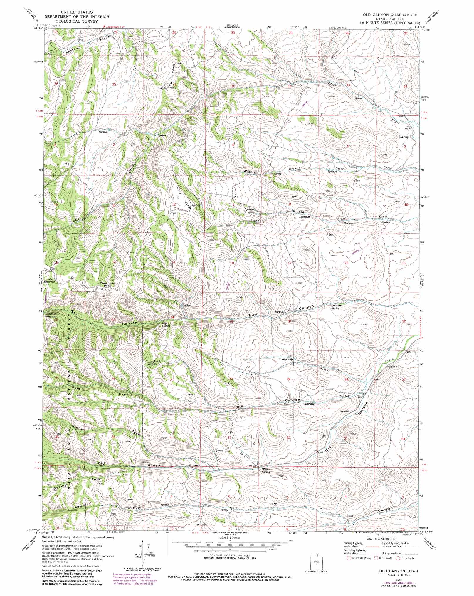
USGS Topo Quad 41111f3 - 1:24,000 scale
| Topo Map Name: | Old Canyon |
| USGS Topo Quad ID: | 41111f3 |
| Print Size: | ca. 21 1/4" wide x 27" high |
| Southeast Coordinates: | 41.625° N latitude / 111.25° W longitude |
| Map Center Coordinates: | 41.6875° N latitude / 111.3125° W longitude |
| U.S. State: | UT |
| Filename: | o41111f3.jpg |
| Download Map JPG Image: | Old Canyon topo map 1:24,000 scale |
| Map Type: | Topographic |
| Topo Series: | 7.5´ |
| Map Scale: | 1:24,000 |
| Source of Map Images: | United States Geological Survey (USGS) |
| Alternate Map Versions: |
Old Canyon UT 1969, updated 1973 Download PDF Buy paper map Old Canyon UT 1969, updated 1986 Download PDF Buy paper map Old Canyon UT 1998, updated 2001 Download PDF Buy paper map Old Canyon UT 2011 Download PDF Buy paper map Old Canyon UT 2014 Download PDF Buy paper map |
| FStopo: | US Forest Service topo Old Canyon is available: Download FStopo PDF Download FStopo TIF |
1:24,000 Topo Quads surrounding Old Canyon
Tony Grove Creek |
Garden City |
Bear Lake South |
Sheeppen Creek |
South Lake |
Temple Peak |
Meadowville |
Laketown |
Sage Creek |
Leefe |
Boulder Mountain |
Red Spur Mountain |
Old Canyon |
Randolph |
Rex Peak |
Hardware Ranch |
Curtis Ridge |
Birch Creek Reservoirs |
Woodruff |
Woodruff Narrows |
Monte Cristo Peak |
Dairy Ridge |
Meachum Ridge |
Neponset Reservoir Nw |
Neponset Reservoir Ne |
> Back to 41111e1 at 1:100,000 scale
> Back to 41110a1 at 1:250,000 scale
> Back to U.S. Topo Maps home
Old Canyon topo map: Gazetteer
Old Canyon: Reservoirs
Nick Reservoir elevation 2391m 7844′Old Canyon: Ridges
Long Ridge elevation 2400m 7874′Old Canyon: Springs
Clawson Spring elevation 2038m 6686′Keg Spring elevation 2176m 7139′
Longhurst Spring elevation 2370m 7775′
Willow Spring elevation 2075m 6807′
Old Canyon: Streams
Spring Creek elevation 1992m 6535′Old Canyon: Summits
Monument Peak elevation 2503m 8211′Twin Peaks elevation 2334m 7657′
Old Canyon: Valleys
Bowery Fork elevation 2159m 7083′New Canyon elevation 1986m 6515′
Old Canyon elevation 2002m 6568′
Pole Canyon elevation 1999m 6558′
Right Fork Old Canyon elevation 2102m 6896′
Old Canyon digital topo map on disk
Buy this Old Canyon topo map showing relief, roads, GPS coordinates and other geographical features, as a high-resolution digital map file on DVD: