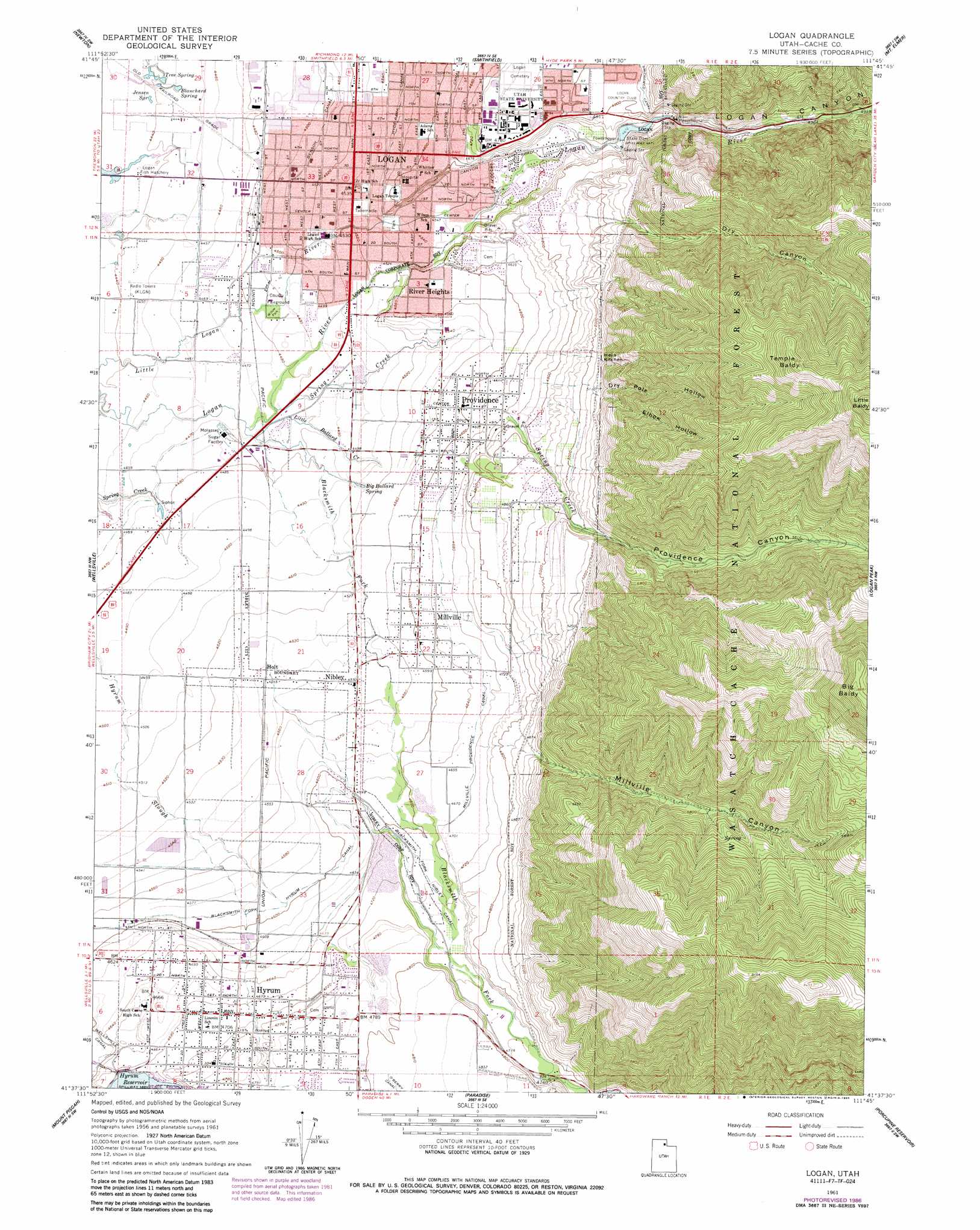
Logan Topo Map Utah
To zoom in, hover over the map of Logan
USGS Topo Quad 41111f7 - 1:24,000 scale
| Topo Map Name: | Logan |
| USGS Topo Quad ID: | 41111f7 |
| Print Size: | ca. 21 1/4" wide x 27" high |
| Southeast Coordinates: | 41.625° N latitude / 111.75° W longitude |
| Map Center Coordinates: | 41.6875° N latitude / 111.8125° W longitude |
| U.S. State: | UT |
| Filename: | o41111f7.jpg |
| Download Map JPG Image: | Logan topo map 1:24,000 scale |
| Map Type: | Topographic |
| Topo Series: | 7.5´ |
| Map Scale: | 1:24,000 |
| Source of Map Images: | United States Geological Survey (USGS) |
| Alternate Map Versions: |
Logan UT 1961, updated 1963 Download PDF Buy paper map Logan UT 1961, updated 1965 Download PDF Buy paper map Logan UT 1961, updated 1986 Download PDF Buy paper map Logan UT 1998, updated 2001 Download PDF Buy paper map Logan UT 2011 Download PDF Buy paper map Logan UT 2014 Download PDF Buy paper map |
| FStopo: | US Forest Service topo Logan is available: Download FStopo PDF Download FStopo TIF |
1:24,000 Topo Quads surrounding Logan
Clarkston |
Trenton |
Richmond |
Naomi Peak |
Tony Grove Creek |
Cutler Dam |
Newton |
Smithfield |
Mount Elmer |
Temple Peak |
Honeyville |
Wellsville |
Logan |
Logan Peak |
Boulder Mountain |
Brigham City |
Mount Pisgah |
Paradise |
Porcupine Reservoir |
Hardware Ranch |
Willard |
Mantua |
James Peak |
Sharp Mountain |
Monte Cristo Peak |
> Back to 41111e1 at 1:100,000 scale
> Back to 41110a1 at 1:250,000 scale
> Back to U.S. Topo Maps home
Logan topo map: Gazetteer
Logan: Areas
Hells Kitchen elevation 1572m 5157′Logan: Canals
Benson Canal elevation 1375m 4511′Blacksmith Fork Nibley Canal elevation 1399m 4589′
Hyde Park Canal elevation 1389m 4557′
Millville Providence Canal elevation 1425m 4675′
Northern Canal elevation 1416m 4645′
Smithfield Canal elevation 1492m 4895′
Wellsville Canal elevation 1403m 4603′
Logan: Dams
State Dam elevation 1429m 4688′Logan: Parks
Millville Face Wildlife Management Area elevation 1957m 6420′Willow Park elevation 1368m 4488′
Logan: Populated Places
Holt elevation 1385m 4543′Hyrum elevation 1432m 4698′
Logan elevation 1382m 4534′
Millville elevation 1407m 4616′
Nibley elevation 1388m 4553′
Providence elevation 1401m 4596′
River Heights elevation 1396m 4580′
Logan: Post Offices
Hyrum Post Office elevation 1432m 4698′Logan Post Office elevation 1383m 4537′
Providence Post Office elevation 1399m 4589′
Logan: Springs
Big Ballard Spring elevation 1370m 4494′Blanchard Spring elevation 1354m 4442′
Jensen Spring elevation 1354m 4442′
Tree Spring elevation 1354m 4442′
Logan: Streams
Blacksmith Fork elevation 1363m 4471′Little Ballard Creek elevation 1364m 4475′
Spring Creek elevation 1364m 4475′
Logan: Summits
Big Baldy elevation 2700m 8858′Little Baldy elevation 2671m 8763′
Temple Baldy elevation 2473m 8113′
Logan: Valleys
Blacksmith Fork Canyon elevation 1446m 4744′Dry Canyon elevation 1544m 5065′
Dry Pole Hollow elevation 1565m 5134′
Elbow Hollow elevation 1565m 5134′
Logan Canyon elevation 1419m 4655′
Millville Canyon elevation 1488m 4881′
Providence Canyon elevation 1546m 5072′
South Fork Millville Canyon elevation 1883m 6177′
Logan digital topo map on disk
Buy this Logan topo map showing relief, roads, GPS coordinates and other geographical features, as a high-resolution digital map file on DVD: