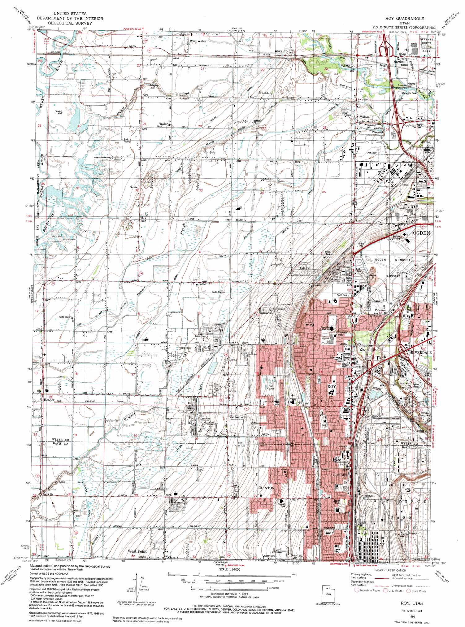
Roy Topo Map Utah
To zoom in, hover over the map of Roy
USGS Topo Quad 41112b1 - 1:24,000 scale
| Topo Map Name: | Roy |
| USGS Topo Quad ID: | 41112b1 |
| Print Size: | ca. 21 1/4" wide x 27" high |
| Southeast Coordinates: | 41.125° N latitude / 112° W longitude |
| Map Center Coordinates: | 41.1875° N latitude / 112.0625° W longitude |
| U.S. State: | UT |
| Filename: | o41112b1.jpg |
| Download Map JPG Image: | Roy topo map 1:24,000 scale |
| Map Type: | Topographic |
| Topo Series: | 7.5´ |
| Map Scale: | 1:24,000 |
| Source of Map Images: | United States Geological Survey (USGS) |
| Alternate Map Versions: |
Roy UT 1955, updated 1956 Download PDF Buy paper map Roy UT 1955, updated 1965 Download PDF Buy paper map Roy UT 1955, updated 1971 Download PDF Buy paper map Roy UT 1955, updated 1978 Download PDF Buy paper map Roy UT 1990, updated 1990 Download PDF Buy paper map Roy UT 1990, updated 1990 Download PDF Buy paper map Roy UT 1999, updated 2001 Download PDF Buy paper map Roy UT 2011 Download PDF Buy paper map Roy UT 2014 Download PDF Buy paper map |
1:24,000 Topo Quads surrounding Roy
Mouth Of Bear River |
Whistler Canal |
Willard |
Mantua |
James Peak |
Willard Spur |
Plain City Sw |
Plain City |
North Ogden |
Huntsville |
Fremont Island |
Ogden Bay |
Roy |
Ogden |
Snow Basin |
Buffalo Point |
Antelope Island North |
Clearfield |
Kaysville |
Peterson |
Plug Peak Ne |
Antelope Island |
Saltair Ne |
Farmington |
Bountiful Peak |
> Back to 41112a1 at 1:100,000 scale
> Back to 41112a1 at 1:250,000 scale
> Back to U.S. Topo Maps home
Roy topo map: Gazetteer
Roy: Airports
Ogden Municipal Airport elevation 1353m 4438′Roy City Municipal Heliport elevation 1365m 4478′
Roy: Canals
Davis-Weber Canal elevation 1405m 4609′Flinders Ditch elevation 1293m 4242′
Hooper Branch Canal elevation 1294m 4245′
North Branch Wilson Canal elevation 1296m 4251′
Northwest Branch Davis-Weber Canal elevation 1368m 4488′
South Branch Wilson Canal elevation 1301m 4268′
South Slaterville Canal elevation 1297m 4255′
Taylor Canal elevation 1287m 4222′
Warren Canal elevation 1295m 4248′
West Weber Canal elevation 1295m 4248′
Wilson Canal elevation 1304m 4278′
Roy: Crossings
Interchange 342 elevation 1376m 4514′Interchange 343 elevation 1350m 4429′
Interchange 345 elevation 1325m 4347′
Interchange 346 elevation 1304m 4278′
Interchange 347 elevation 1298m 4258′
Interchange 81 elevation 1342m 4402′
Roy: Dams
Slaterville Diversion Dam elevation 1299m 4261′Roy: Parks
Civic Center Park elevation 1362m 4468′Clinton City Park elevation 1321m 4333′
Kiwanis Park elevation 1348m 4422′
Meadows Park elevation 1354m 4442′
Ogden Nature Center elevation 1299m 4261′
Riverdale Park elevation 1345m 4412′
Roy Park elevation 1348m 4422′
White Park elevation 1371m 4498′
Roy: Populated Places
Al Vi Village elevation 1336m 4383′Aland of Honey elevation 1301m 4268′
Allred elevation 1351m 4432′
Alpine Ranchettes elevation 1303m 4274′
Alpine Ranchettes Two elevation 1303m 4274′
Anderson West Acres elevation 1296m 4251′
Apple Estates elevation 1369m 4491′
Apple Park elevation 1336m 4383′
Apple Valley Estates elevation 1364m 4475′
Arsenal elevation 1401m 4596′
Arsenal Villa elevation 1368m 4488′
Arthur Jones Estate elevation 1330m 4363′
Aspen West elevation 1335m 4379′
Barton elevation 1313m 4307′
Barton elevation 1334m 4376′
Barton-Thompson elevation 1333m 4373′
Bay View Park elevation 1363m 4471′
Bel Air elevation 1379m 4524′
Bellevue Place elevation 1329m 4360′
Berrett elevation 1345m 4412′
Bingham Estates elevation 1291m 4235′
Bonham elevation 1349m 4425′
Brownscott Manor elevation 1358m 4455′
Buena Vista elevation 1372m 4501′
Burmont Park elevation 1347m 4419′
C C Ann Estates elevation 1315m 4314′
Carriage Lane Number Two elevation 1336m 4383′
Carriage Place elevation 1332m 4370′
Cedar Ridge elevation 1362m 4468′
Cedar Ridge Number Tow elevation 1347m 4419′
Celeste Place Townhouses elevation 1356m 4448′
Chateau-Park Condominium elevation 1361m 4465′
Chestnut Park elevation 1334m 4376′
Christensen elevation 1332m 4370′
Clays Ranchettes elevation 1309m 4294′
Clint Village elevation 1344m 4409′
Clinton elevation 1339m 4393′
Colonial Gardens Condominium elevation 1345m 4412′
Colonial Plaza Condominium elevation 1383m 4537′
Commonwealth Square elevation 1382m 4534′
Commonwealth Square Condominium elevation 1382m 4534′
Cottonwood Meadows elevation 1292m 4238′
Country Estates Park elevation 1311m 4301′
Country Homes elevation 1311m 4301′
Country Lane elevation 1318m 4324′
Country Meadows elevation 1308m 4291′
Country Park elevation 1295m 4248′
Coy elevation 1328m 4356′
Cozydale elevation 1378m 4520′
Crest View Acres elevation 1382m 4534′
Deanetta elevation 1362m 4468′
DeGiorgio elevation 1292m 4238′
Diamond Hills elevation 1344m 4409′
Donita elevation 1380m 4527′
Draayer elevation 1351m 4432′
El Centro Estates elevation 1360m 4461′
Elta Glen elevation 1330m 4363′
Enchanted Homes Addition elevation 1386m 4547′
English Manor elevation 1366m 4481′
Eves Garden elevation 1343m 4406′
Eves Garden elevation 1344m 4409′
Evona elevation 1324m 4343′
Fairmount Park elevation 1338m 4389′
Fairmount Park Annex elevation 1338m 4389′
Fairway Estates elevation 1325m 4347′
Farr Number Two elevation 1355m 4445′
Fawcett elevation 1366m 4481′
Fowers elevation 1293m 4242′
Foxglen elevation 1302m 4271′
Fuit elevation 1300m 4265′
Garden Acres elevation 1300m 4265′
Gilene elevation 1364m 4475′
Glade-Nelson elevation 1380m 4527′
Golden West Villa elevation 1337m 4386′
Goodfellow elevation 1336m 4383′
Graig Dale elevation 1369m 4491′
Great Basin Addition elevation 1363m 4471′
Hal-Vern Park Addition elevation 1357m 4452′
Harmony Park elevation 1367m 4484′
Harveys Redwood Estates elevation 1360m 4461′
Hatch elevation 1305m 4281′
He Flys elevation 1317m 4320′
Heather Heights elevation 1367m 4484′
Herefordshire elevation 1366m 4481′
Herefordshire Condominium elevation 1368m 4488′
Heritage Square elevation 1348m 4422′
Heritage Square elevation 1348m 4422′
Hill Acres elevation 1295m 4248′
Hills of Homes elevation 1375m 4511′
Holley Acres elevation 1305m 4281′
Holley and Whitney elevation 1341m 4399′
Hooper elevation 1293m 4242′
Hy-Mesa elevation 1375m 4511′
Interwest Condominium Project Phase A elevation 1332m 4370′
Jackson Orchards elevation 1368m 4488′
Jill elevation 1360m 4461′
John Fuit elevation 1318m 4324′
Jones elevation 1325m 4347′
Kanesville elevation 1294m 4245′
Kap elevation 1310m 4297′
Kelley Kay Acres elevation 1295m 4248′
Kentwood Condominium elevation 1338m 4389′
Kentwood Estates elevation 1338m 4389′
Kingsville Junction elevation 1295m 4248′
La Loma elevation 1380m 4527′
Lake View Ward elevation 1378m 4520′
Lakeside Acres elevation 1295m 4248′
Lakeside Park elevation 1348m 4422′
Lakeview Equestrian Park elevation 1310m 4297′
Lakeview Gardens elevation 1338m 4389′
Laurel Lea elevation 1324m 4343′
Lavell elevation 1311m 4301′
Lawndale Addition elevation 1351m 4432′
Lazy L Estates elevation 1366m 4481′
Lee Mesa elevation 1365m 4478′
Lemans elevation 1350m 4429′
Lewis Estates elevation 1293m 4242′
Lincoln Court Condominium elevation 1313m 4307′
Linda Vista elevation 1374m 4507′
Linda Vista elevation 1376m 4514′
Loma Bonita elevation 1347m 4419′
Lori Ann Estates elevation 1325m 4347′
Lucin elevation 1294m 4245′
Mansion Heights Addition elevation 1344m 4409′
Maplewood Estates elevation 1377m 4517′
Margretta elevation 1334m 4376′
Marianne Condominium elevation 1378m 4520′
Marriott elevation 1300m 4265′
Marvins elevation 1332m 4370′
Maybrook elevation 1388m 4553′
Meadowlane elevation 1336m 4383′
Mel Stephenson elevation 1293m 4242′
Midland Farms elevation 1315m 4314′
Midland Square elevation 1314m 4311′
Mitchell Estates elevation 1347m 4419′
Montrose Park elevation 1357m 4452′
Morby Park elevation 1377m 4517′
Mountair Park elevation 1312m 4304′
Muir Meadows elevation 1339m 4393′
Municipal Acres elevation 1375m 4511′
Municipal Park elevation 1357m 4452′
Murdock elevation 1397m 4583′
New Hampton Manor elevation 1313m 4307′
Nielson Estates elevation 1311m 4301′
North Crest Manor elevation 1358m 4455′
Northpoint Condominium elevation 1370m 4494′
Ogden Heights elevation 1359m 4458′
Olivewood Park elevation 1345m 4412′
Page Estates elevation 1316m 4317′
Par Four elevation 1335m 4379′
Park Lake elevation 1366m 4481′
Parker elevation 1298m 4258′
Parks elevation 1354m 4442′
Parkside elevation 1320m 4330′
Peppermint Park elevation 1354m 4442′
Peterson elevation 1360m 4461′
Pheasant Run Estates elevation 1328m 4356′
Pinto Acres elevation 1318m 4324′
Pleasant View elevation 1366m 4481′
Pony Acres Estates elevation 1310m 4297′
Pony Acres Estates elevation 1316m 4317′
Purser elevation 1380m 4527′
Quail Point elevation 1365m 4478′
Raymond Shupe Addition elevation 1371m 4498′
Rayneer elevation 1331m 4366′
Relico elevation 1319m 4327′
Rich Acres elevation 1300m 4265′
Richton Ranchettes elevation 1300m 4265′
Ridgewood Estates elevation 1376m 4514′
Riverdale elevation 1332m 4370′
Roi Dell elevation 1360m 4461′
Roi-Dell elevation 1361m 4465′
Rosewood Estates elevation 1381m 4530′
Rosewood Manor Condominium elevation 1380m 4527′
Roskelley elevation 1325m 4347′
Roy elevation 1384m 4540′
Roy Park Addition elevation 1380m 4527′
Roy West elevation 1323m 4340′
Royset Park Addition and Annex elevation 1382m 4534′
Sandalwood Square elevation 1340m 4396′
Sandridge Estates elevation 1316m 4317′
Scotts Dale elevation 1380m 4527′
Shamrock elevation 1376m 4514′
Shannondoah Estates elevation 1292m 4238′
Sherwood Oaks Condominium elevation 1346m 4416′
Snap-N-Fox Farms elevation 1314m 4311′
Stoneybrook Estates elevation 1296m 4251′
Suburban Heights elevation 1384m 4540′
Sun elevation 1332m 4370′
Sun Ray elevation 1337m 4386′
Sundown Estates elevation 1365m 4478′
Sunray elevation 1378m 4520′
Sunrise Park elevation 1369m 4491′
Sunset elevation 1371m 4498′
Sunset elevation 1375m 4511′
Sunset Dale elevation 1368m 4488′
Sunset Dale elevation 1370m 4494′
Sunset Square elevation 1380m 4527′
Swan Creek Estates elevation 1292m 4238′
Tanner elevation 1375m 4511′
Taylor elevation 1292m 4238′
Terry Dale elevation 1367m 4484′
Terry Estates elevation 1357m 4452′
The Hillsite Addition elevation 1384m 4540′
The Parsons Place elevation 1357m 4452′
Thompson Gardens elevation 1382m 4534′
Town and Country Estates elevation 1315m 4314′
Tri-S Village Estates elevation 1292m 4238′
Tubbs elevation 1314m 4311′
Tullis Addition elevation 1355m 4445′
Val-Jo elevation 1326m 4350′
Valley Green Estates elevation 1301m 4268′
Valley Park Estates elevation 1362m 4468′
Valley Side elevation 1361m 4465′
Valley View Acres elevation 1365m 4478′
Valleywest elevation 1354m 4442′
Vern G Taylor elevation 1286m 4219′
Villa Moritz elevation 1383m 4537′
Wen Dale Park elevation 1334m 4376′
West Haven elevation 1302m 4271′
West Hills elevation 1329m 4360′
West Side Estates elevation 1291m 4235′
West View Park elevation 1365m 4478′
West Weber elevation 1292m 4238′
Westbrook elevation 1331m 4366′
Westbrook elevation 1330m 4363′
Western Willows Cluster elevation 1295m 4248′
Westlake Village elevation 1324m 4343′
Westridge elevation 1370m 4494′
Wheatridge Estates elevation 1314m 4311′
White elevation 1377m 4517′
William R Patterson elevation 1352m 4435′
Willow Wood elevation 1296m 4251′
Wilson elevation 1304m 4278′
Roy: Post Offices
Hooper Post Office elevation 1293m 4242′Roy Post Office elevation 1383m 4537′
Roy: Streams
Ogden River elevation 1301m 4268′Walker Slough elevation 1284m 4212′
Roy digital topo map on disk
Buy this Roy topo map showing relief, roads, GPS coordinates and other geographical features, as a high-resolution digital map file on DVD: