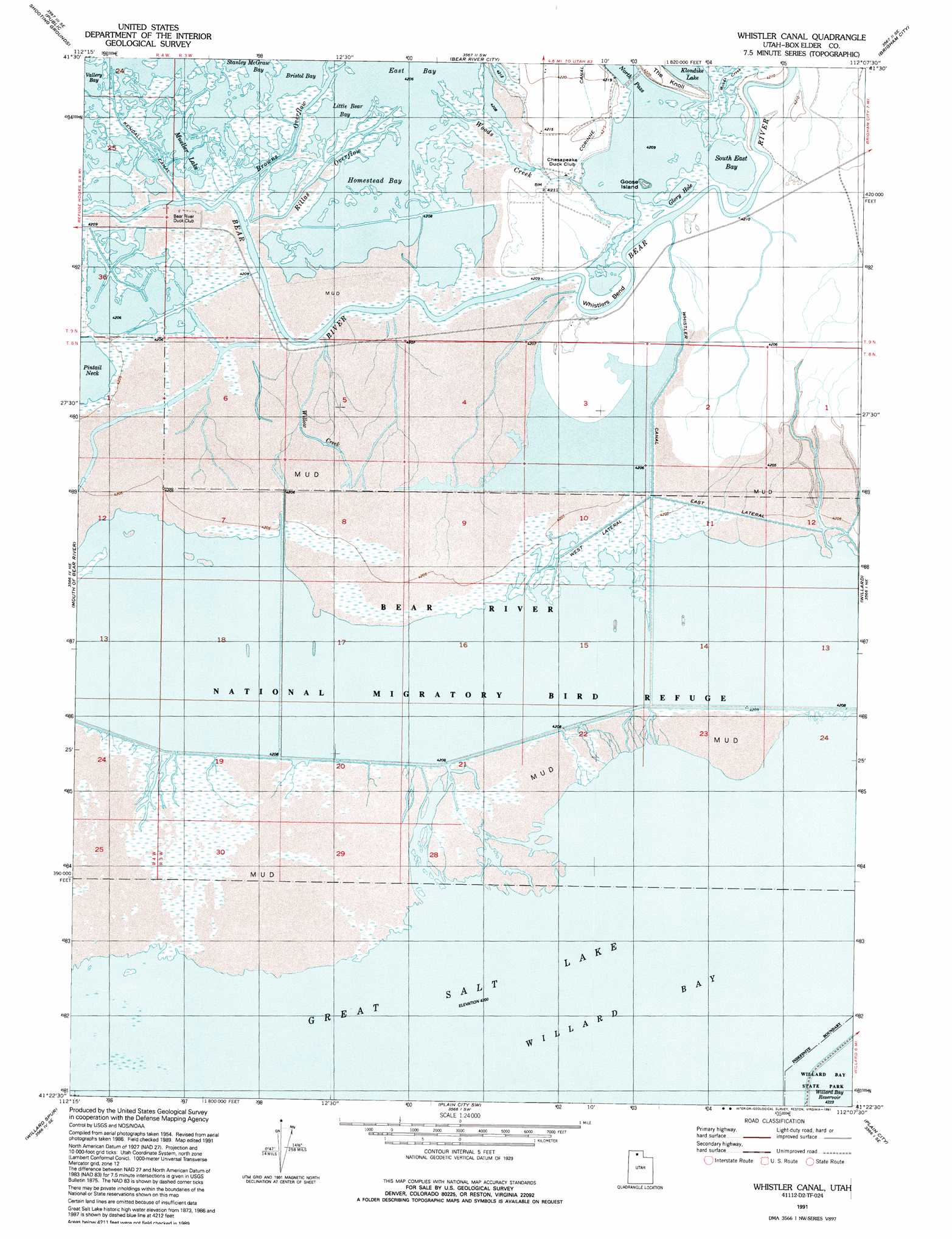
Whistler Canal Topo Map Utah
To zoom in, hover over the map of Whistler Canal
USGS Topo Quad 41112d2 - 1:24,000 scale
| Topo Map Name: | Whistler Canal |
| USGS Topo Quad ID: | 41112d2 |
| Print Size: | ca. 21 1/4" wide x 27" high |
| Southeast Coordinates: | 41.375° N latitude / 112.125° W longitude |
| Map Center Coordinates: | 41.4375° N latitude / 112.1875° W longitude |
| U.S. State: | UT |
| Filename: | o41112d2.jpg |
| Download Map JPG Image: | Whistler Canal topo map 1:24,000 scale |
| Map Type: | Topographic |
| Topo Series: | 7.5´ |
| Map Scale: | 1:24,000 |
| Source of Map Images: | United States Geological Survey (USGS) |
| Alternate Map Versions: |
Whistler Canal UT 1954, updated 1956 Download PDF Buy paper map Whistler Canal UT 1972, updated 1974 Download PDF Buy paper map Whistler Canal UT 1991, updated 1991 Download PDF Buy paper map Whistler Canal UT 2011 Download PDF Buy paper map Whistler Canal UT 2014 Download PDF Buy paper map |
1:24,000 Topo Quads surrounding Whistler Canal
Lampo Junction |
Thatcher Mountain |
Tremonton |
Honeyville |
Wellsville |
Thatcher Mountain Sw |
Public Shooting Grounds |
Bear River City |
Brigham City |
Mount Pisgah |
East Promontory |
Mouth Of Bear River |
Whistler Canal |
Willard |
Mantua |
Pokes Point |
Willard Spur |
Plain City Sw |
Plain City |
North Ogden |
Promontory Point |
Fremont Island |
Ogden Bay |
Roy |
Ogden |
> Back to 41112a1 at 1:100,000 scale
> Back to 41112a1 at 1:250,000 scale
> Back to U.S. Topo Maps home
Whistler Canal topo map: Gazetteer
Whistler Canal: Bays
Bristol Bay elevation 1285m 4215′Homestead Bay elevation 1284m 4212′
Little Bear Bay elevation 1284m 4212′
South East Bay elevation 1284m 4212′
Willard Bay elevation 1281m 4202′
Whistler Canal: Bends
Whistlers Bend elevation 1285m 4215′Whistler Canal: Canals
East Lateral elevation 1281m 4202′Kendall Canal elevation 1284m 4212′
West Lateral elevation 1282m 4206′
Whistler Canal elevation 1283m 4209′
Whistler Canal: Channels
Browns Overflow elevation 1284m 4212′North Pass elevation 1284m 4212′
Rillas Overflow elevation 1284m 4212′
Whistler Canal: Islands
Goose Island elevation 1288m 4225′Whistler Canal: Lakes
Glory Hole elevation 1284m 4212′Mueller Lake elevation 1284m 4212′
Whistler Canal: Reservoirs
Willard Bay Reservoir elevation 1286m 4219′Whistler Canal: Streams
Willow Creek elevation 1283m 4209′Woods Creek elevation 1285m 4215′
Whistler Canal digital topo map on disk
Buy this Whistler Canal topo map showing relief, roads, GPS coordinates and other geographical features, as a high-resolution digital map file on DVD: