Cutler Dam Topo Map Utah
To zoom in, hover over the map of Cutler Dam
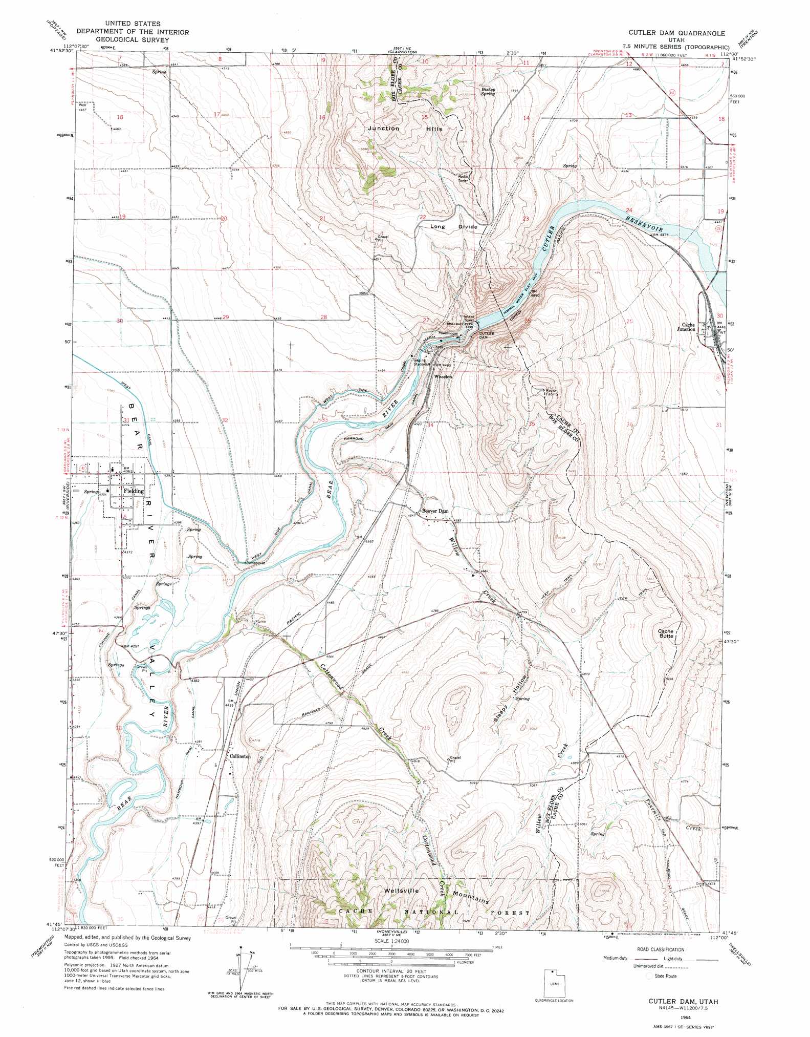
USGS Topo Quad 41112g1 - 1:24,000 scale
| Topo Map Name: | Cutler Dam |
| USGS Topo Quad ID: | 41112g1 |
| Print Size: | ca. 21 1/4" wide x 27" high |
| Southeast Coordinates: | 41.75° N latitude / 112° W longitude |
| Map Center Coordinates: | 41.8125° N latitude / 112.0625° W longitude |
| U.S. State: | UT |
| Filename: | o41112g1.jpg |
| Download Map JPG Image: | Cutler Dam topo map 1:24,000 scale |
| Map Type: | Topographic |
| Topo Series: | 7.5´ |
| Map Scale: | 1:24,000 |
| Source of Map Images: | United States Geological Survey (USGS) |
| Alternate Map Versions: |
Cutler Dam UT 1964, updated 1966 Download PDF Buy paper map Cutler Dam UT 1998, updated 2001 Download PDF Buy paper map Cutler Dam UT 2011 Download PDF Buy paper map Cutler Dam UT 2014 Download PDF Buy paper map |
| FStopo: | US Forest Service topo Cutler Dam is available: Download FStopo PDF Download FStopo TIF |
1:24,000 Topo Quads surrounding Cutler Dam
Samaria |
Henderson Creek |
Weston Canyon |
Weston |
Franklin |
Limekiln Knoll |
Portage |
Clarkston |
Trenton |
Richmond |
Blind Springs |
Riverside |
Cutler Dam |
Newton |
Smithfield |
Thatcher Mountain |
Tremonton |
Honeyville |
Wellsville |
Logan |
Public Shooting Grounds |
Bear River City |
Brigham City |
Mount Pisgah |
Paradise |
> Back to 41112e1 at 1:100,000 scale
> Back to 41112a1 at 1:250,000 scale
> Back to U.S. Topo Maps home
Cutler Dam topo map: Gazetteer
Cutler Dam: Canals
Hammond Main Canal elevation 1338m 4389′West Side Canal elevation 1337m 4386′
Cutler Dam: Dams
Cutler Dam elevation 1338m 4389′Cutler Dam: Parks
Historical Monument Stage Station elevation 1300m 4265′Cutler Dam: Populated Places
Cache Junction elevation 1356m 4448′Collinston elevation 1351m 4432′
Fielding elevation 1333m 4373′
Wheelon elevation 1388m 4553′
Cutler Dam: Reservoirs
Cutler Reservoir elevation 1338m 4389′Cutler Dam: Ridges
Long Divide elevation 1563m 5127′Cutler Dam: Springs
Bishop Spring elevation 1542m 5059′Cutler Dam: Streams
Cottonwood Creek elevation 1295m 4248′The Slough elevation 1346m 4416′
Willow Creek elevation 1299m 4261′
Cutler Dam: Summits
Black Rock elevation 1540m 5052′Cache Butte elevation 1631m 5351′
Junction Hills elevation 1804m 5918′
Cutler Dam: Valleys
Sleepy Hollow elevation 1460m 4790′Cutler Dam digital topo map on disk
Buy this Cutler Dam topo map showing relief, roads, GPS coordinates and other geographical features, as a high-resolution digital map file on DVD: