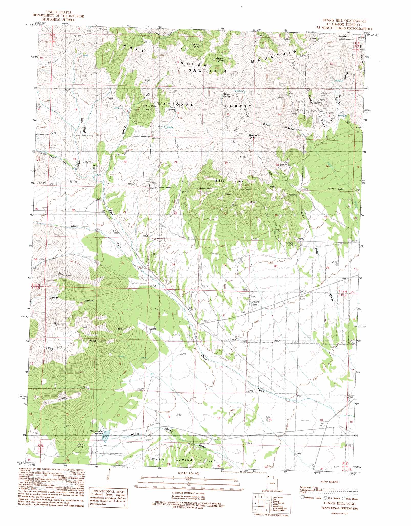
Dennis Hill Topo Map Utah
To zoom in, hover over the map of Dennis Hill
USGS Topo Quad 41113g5 - 1:24,000 scale
| Topo Map Name: | Dennis Hill |
| USGS Topo Quad ID: | 41113g5 |
| Print Size: | ca. 21 1/4" wide x 27" high |
| Southeast Coordinates: | 41.75° N latitude / 113.5° W longitude |
| Map Center Coordinates: | 41.8125° N latitude / 113.5625° W longitude |
| U.S. State: | UT |
| Filename: | o41113g5.jpg |
| Download Map JPG Image: | Dennis Hill topo map 1:24,000 scale |
| Map Type: | Topographic |
| Topo Series: | 7.5´ |
| Map Scale: | 1:24,000 |
| Source of Map Images: | United States Geological Survey (USGS) |
| Alternate Map Versions: |
Dennis Hill UT 1990, updated 1990 Download PDF Buy paper map Dennis Hill UT 2001, updated 2006 Download PDF Buy paper map Dennis Hill UT 2011 Download PDF Buy paper map Dennis Hill UT 2014 Download PDF Buy paper map |
| FStopo: | US Forest Service topo Dennis Hill is available: Download FStopo PDF Download FStopo TIF |
1:24,000 Topo Quads surrounding Dennis Hill
Lyman Pass |
Almo |
Jim Sage Canyon |
Chokecherry Canyon |
Naf |
Cotton Thomas Basin |
Buck Hollow |
Yost |
Standrod |
Rosevere Point |
Kimbell Creek |
Lynn Reservoir |
Dennis Hill |
Rosette |
Park Valley |
Ingham Canyon |
Potters Creek |
Warm Spring Hills |
Runswick Wash |
Russian Knoll |
Rocky Pass Peak |
Emigrant Pass |
Prohibition Spring |
Red Dome |
Matlin |
> Back to 41113e1 at 1:100,000 scale
> Back to 41112a1 at 1:250,000 scale
> Back to U.S. Topo Maps home
Dennis Hill topo map: Gazetteer
Dennis Hill: Mines
Century Mine elevation 2570m 8431′Dennis Hill: Reservoirs
Warm Spring Reservoir elevation 1726m 5662′Dennis Hill: Springs
Birch Spring elevation 2109m 6919′Black Hills Spring elevation 2027m 6650′
Mud Spring elevation 2402m 7880′
Spencer Spring elevation 2307m 7568′
Stevens Spring elevation 2329m 7641′
Warm Spring elevation 1750m 5741′
Willow Spring elevation 2272m 7454′
Dennis Hill: Streams
Clarks Basin Creek elevation 1891m 6204′Left Hand Fork Dove Creek elevation 1766m 5793′
Middle Fork Dove Creek elevation 1862m 6108′
Right Hand Fork Dove Creek elevation 1766m 5793′
Spring Creek elevation 1851m 6072′
Dennis Hill: Summits
Black Hills elevation 2151m 7057′Dennis Hill elevation 2233m 7326′
Nut Pine Hills elevation 2102m 6896′
Dennis Hill: Valleys
Century Hollow elevation 1899m 6230′Corner Creek Canyon elevation 1891m 6204′
Danish Hollow elevation 1721m 5646′
Suzanna Canyon elevation 1926m 6318′
Dennis Hill digital topo map on disk
Buy this Dennis Hill topo map showing relief, roads, GPS coordinates and other geographical features, as a high-resolution digital map file on DVD: