Wine Cup Ranch Sw Topo Map Nevada
To zoom in, hover over the map of Wine Cup Ranch Sw
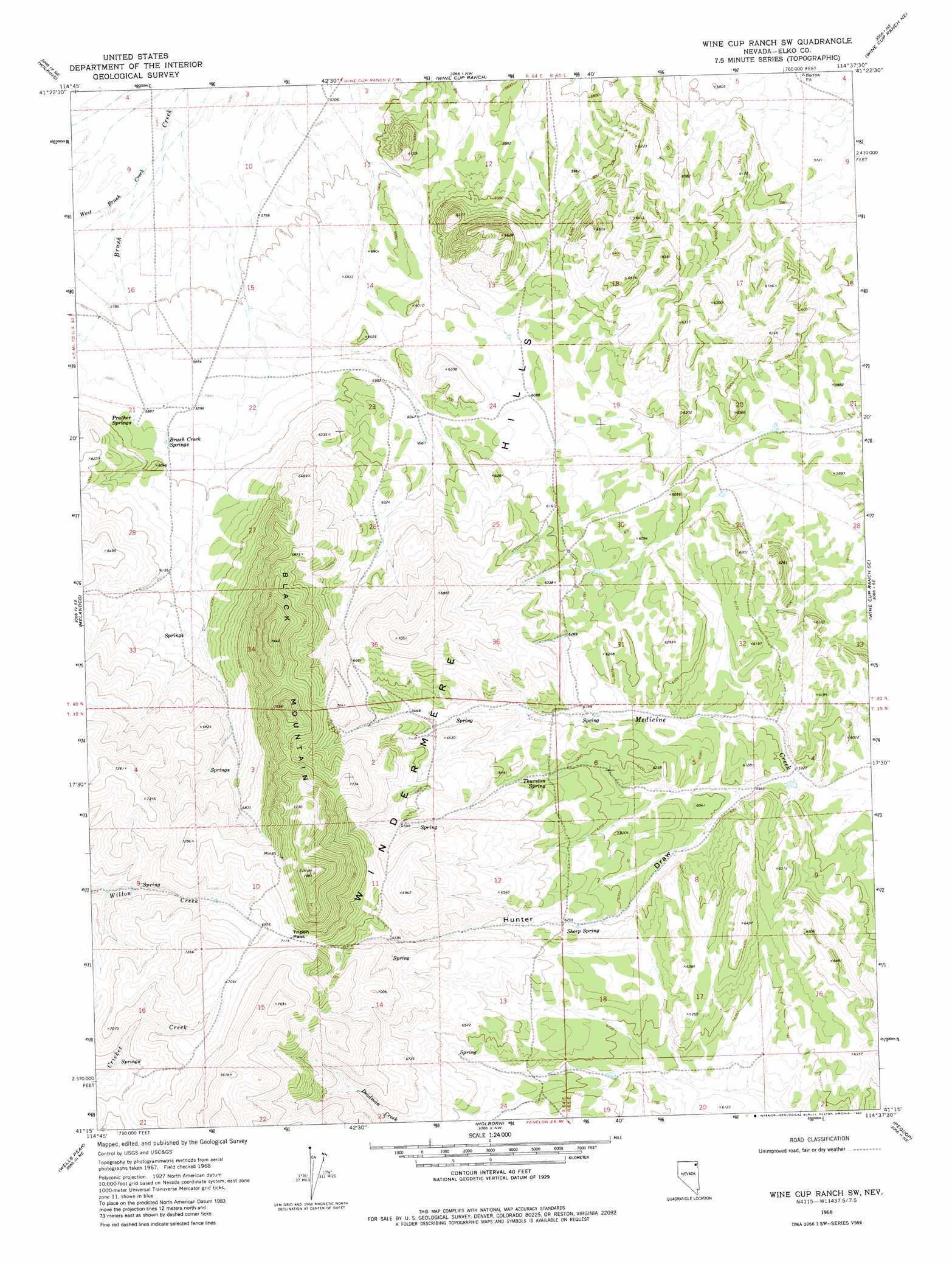
USGS Topo Quad 41114c6 - 1:24,000 scale
| Topo Map Name: | Wine Cup Ranch Sw |
| USGS Topo Quad ID: | 41114c6 |
| Print Size: | ca. 21 1/4" wide x 27" high |
| Southeast Coordinates: | 41.25° N latitude / 114.625° W longitude |
| Map Center Coordinates: | 41.3125° N latitude / 114.6875° W longitude |
| U.S. State: | NV |
| Filename: | o41114c6.jpg |
| Download Map JPG Image: | Wine Cup Ranch Sw topo map 1:24,000 scale |
| Map Type: | Topographic |
| Topo Series: | 7.5´ |
| Map Scale: | 1:24,000 |
| Source of Map Images: | United States Geological Survey (USGS) |
| Alternate Map Versions: |
Wine Cup Ranch SW NV 1968, updated 1972 Download PDF Buy paper map Wine Cup Ranch SW NV 1968, updated 1980 Download PDF Buy paper map Wine Cup Ranch SW NV 2012 Download PDF Buy paper map Wine Cup Ranch SW NV 2014 Download PDF Buy paper map |
1:24,000 Topo Quads surrounding Wine Cup Ranch Sw
Boies Reservoir |
Harris Canyon |
Knoll Mountain |
Knoll Mountain Se |
Chicken Springs |
Loomis Mountain |
Wilkins |
Wine Cup Ranch |
Wine Cup Ranch Ne |
Ninemile Mountain |
Summer Camp |
Melandco |
Wine Cup Ranch Sw |
Wine Cup Ranch Se |
Ninemile Mountain Sw |
Oxley Peak |
Wells Peak |
Holborn |
Pequop |
Valley Pass |
Wells |
Moor Summit |
Pequop Summit Sw |
Pequop Summit |
Cobre |
> Back to 41114a1 at 1:100,000 scale
> Back to 41114a1 at 1:250,000 scale
> Back to U.S. Topo Maps home
Wine Cup Ranch Sw topo map: Gazetteer
Wine Cup Ranch Sw: Gaps
Tripon Pass elevation 2170m 7119′Wine Cup Ranch Sw: Springs
Brush Creek Springs elevation 1807m 5928′Prather Springs elevation 1807m 5928′
Sheep Spring elevation 1911m 6269′
Thurston Spring elevation 1904m 6246′
Thurston Spring elevation 1876m 6154′
Willow Creek Spring elevation 2108m 6916′
Wine Cup Ranch Sw: Streams
West Brush Creek elevation 1735m 5692′Wine Cup Ranch Sw: Summits
Black Mountain elevation 2394m 7854′Wine Cup Ranch Sw: Valleys
Hunter Draw elevation 1805m 5921′Wine Cup Ranch Sw digital topo map on disk
Buy this Wine Cup Ranch Sw topo map showing relief, roads, GPS coordinates and other geographical features, as a high-resolution digital map file on DVD: