Emigrant Springs Topo Map Nevada
To zoom in, hover over the map of Emigrant Springs
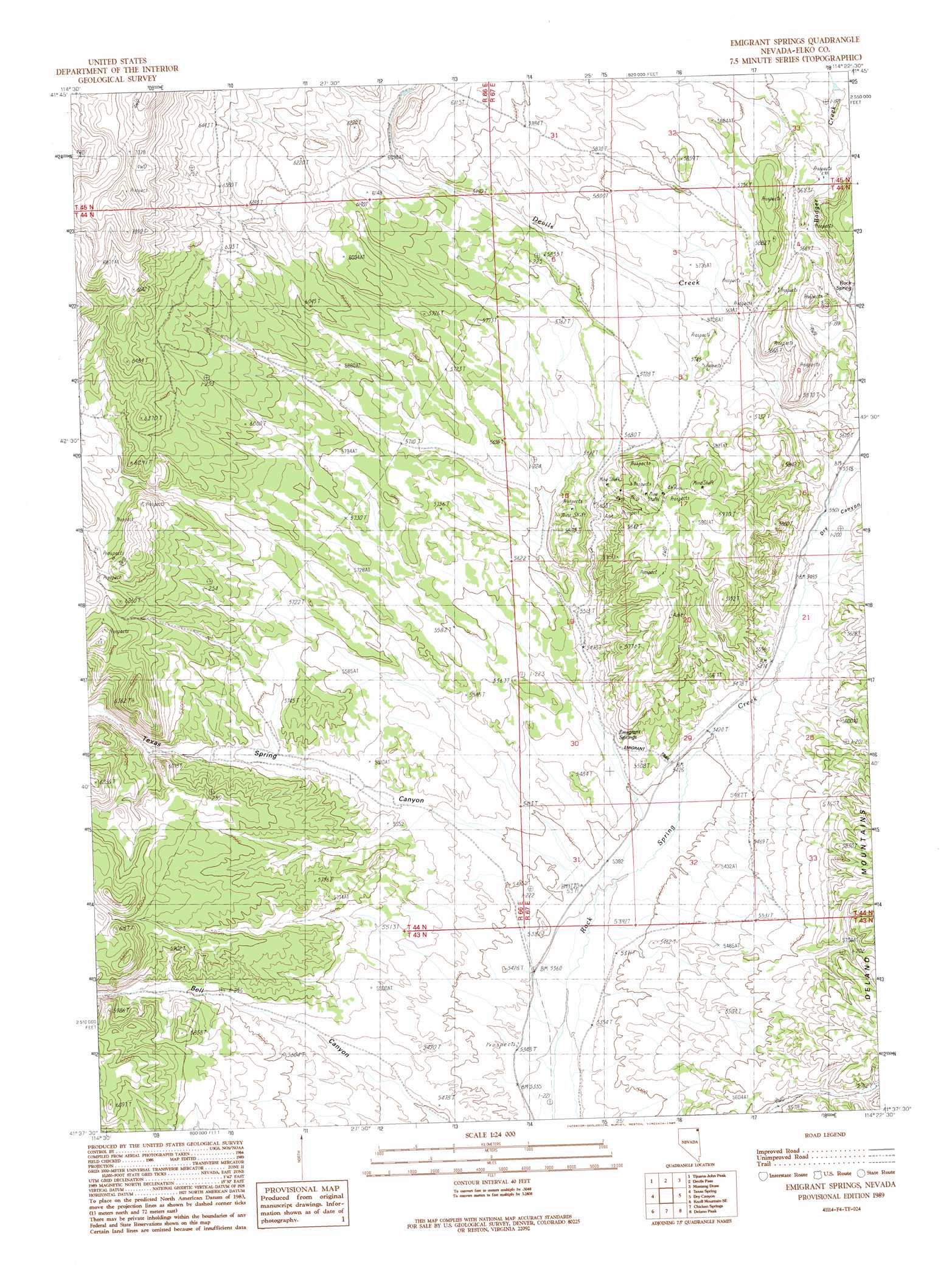
USGS Topo Quad 41114f4 - 1:24,000 scale
| Topo Map Name: | Emigrant Springs |
| USGS Topo Quad ID: | 41114f4 |
| Print Size: | ca. 21 1/4" wide x 27" high |
| Southeast Coordinates: | 41.625° N latitude / 114.375° W longitude |
| Map Center Coordinates: | 41.6875° N latitude / 114.4375° W longitude |
| U.S. State: | NV |
| Filename: | o41114f4.jpg |
| Download Map JPG Image: | Emigrant Springs topo map 1:24,000 scale |
| Map Type: | Topographic |
| Topo Series: | 7.5´ |
| Map Scale: | 1:24,000 |
| Source of Map Images: | United States Geological Survey (USGS) |
| Alternate Map Versions: |
Emigrant Springs NV 1989, updated 1989 Download PDF Buy paper map Emigrant Springs NV 2012 Download PDF Buy paper map Emigrant Springs NV 2014 Download PDF Buy paper map |
1:24,000 Topo Quads surrounding Emigrant Springs
Jackpot |
East Of Jackpot |
Gollaher Mountain |
Stratton Spring |
Fivemile Gulch |
Middle Stack Mountain |
Tijuana John Peak |
Devils Pass |
Mustang Draw |
Cedar Mountain Draw |
Blanchard Mountain |
Texas Spring |
Emigrant Springs |
Dry Canyon |
The Baldies |
Knoll Mountain |
Knoll Mountain Se |
Chicken Springs |
Delano Peak |
Crittenden Springs |
Wine Cup Ranch |
Wine Cup Ranch Ne |
Ninemile Mountain |
Ninemile Mountain Ne |
Twelvemile Ranch |
> Back to 41114e1 at 1:100,000 scale
> Back to 41114a1 at 1:250,000 scale
> Back to U.S. Topo Maps home
Emigrant Springs topo map: Gazetteer
Emigrant Springs: Springs
Cold Springs elevation 1650m 5413′Emigrant Springs elevation 1666m 5465′
Rock Spring elevation 1706m 5597′
Emigrant Springs: Streams
Badger Creek elevation 1703m 5587′Emigrant Springs: Valleys
Dry Canyon elevation 1682m 5518′Texas Spring Canyon elevation 1637m 5370′
Emigrant Springs: Wells
Rock Springs Well elevation 1697m 5567′Winecup Well elevation 1711m 5613′
Emigrant Springs digital topo map on disk
Buy this Emigrant Springs topo map showing relief, roads, GPS coordinates and other geographical features, as a high-resolution digital map file on DVD: