Welcome Topo Map Nevada
To zoom in, hover over the map of Welcome
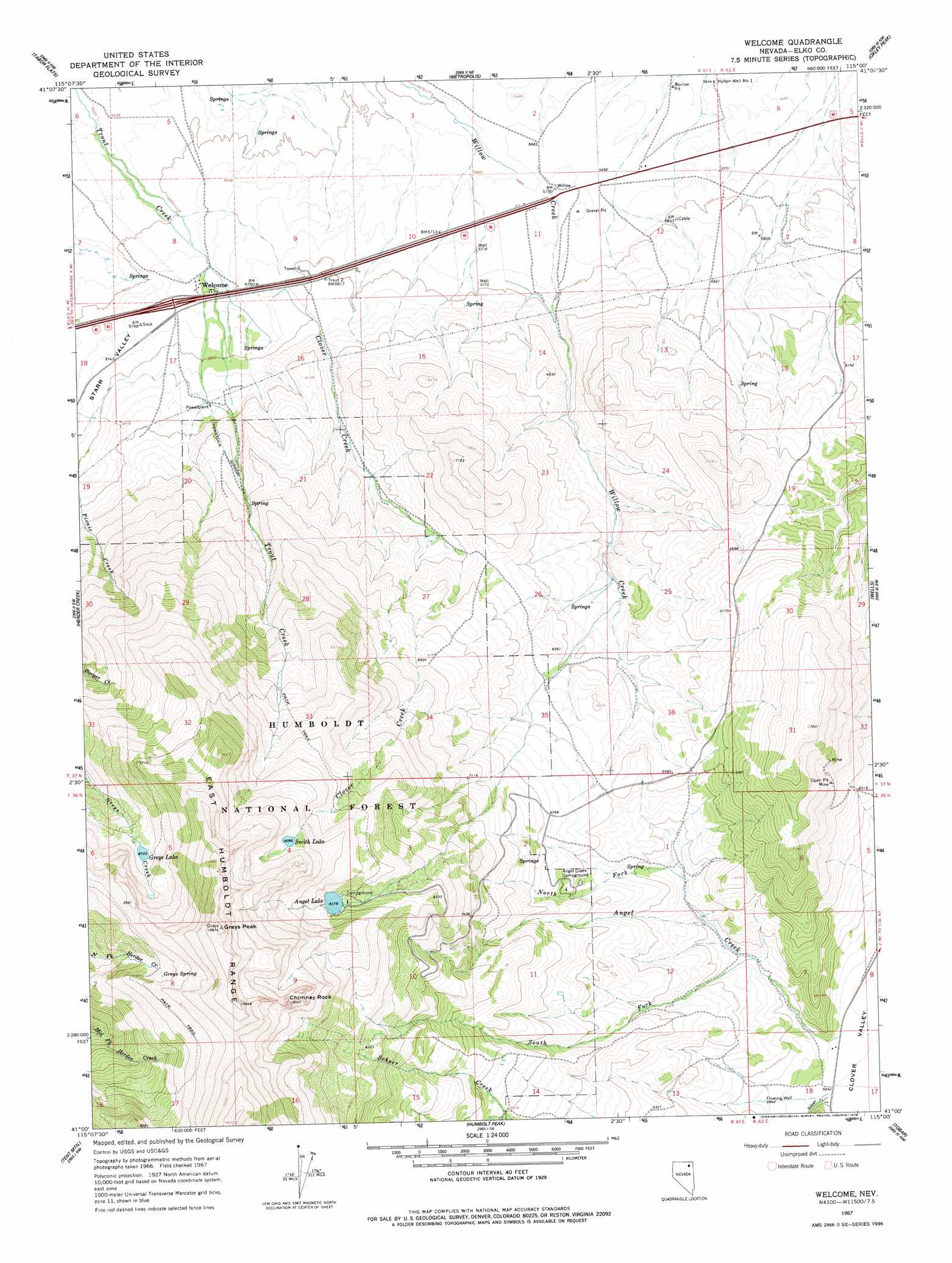
USGS Topo Quad 41115a1 - 1:24,000 scale
| Topo Map Name: | Welcome |
| USGS Topo Quad ID: | 41115a1 |
| Print Size: | ca. 21 1/4" wide x 27" high |
| Southeast Coordinates: | 41° N latitude / 115° W longitude |
| Map Center Coordinates: | 41.0625° N latitude / 115.0625° W longitude |
| U.S. State: | NV |
| Filename: | o41115a1.jpg |
| Download Map JPG Image: | Welcome topo map 1:24,000 scale |
| Map Type: | Topographic |
| Topo Series: | 7.5´ |
| Map Scale: | 1:24,000 |
| Source of Map Images: | United States Geological Survey (USGS) |
| Alternate Map Versions: |
Welcome NV 1967, updated 1971 Download PDF Buy paper map Welcome NV 1967, updated 1978 Download PDF Buy paper map Welcome NV 2012 Download PDF Buy paper map Welcome NV 2015 Download PDF Buy paper map |
| FStopo: | US Forest Service topo Welcome is available: Download FStopo PDF Download FStopo TIF |
1:24,000 Topo Quads surrounding Welcome
Hot Springs Creek |
Black Butte Sw |
Black Butte |
Summer Camp |
Melandco |
Twin Buttes |
Tabor Flats |
Metropolis |
Oxley Peak |
Wells Peak |
Deeth |
Herder Creek |
Welcome |
Wells |
Moor Summit |
Heelfly Creek |
Tent Mountain |
Humboldt Peak |
Tobar |
Snow Water Lake Ne |
Soldier Peak |
Secret Valley |
Gordon Creek |
Snow Water Lake |
Ventosa |
> Back to 41115a1 at 1:100,000 scale
> Back to 41114a1 at 1:250,000 scale
> Back to U.S. Topo Maps home
Welcome topo map: Gazetteer
Welcome: Crossings
Welcome Interchange elevation 1745m 5725′Welcome: Dams
Angel Lake Dam elevation 2555m 8382′Welcome: Lakes
Greys Lake elevation 2666m 8746′Smith Lake elevation 2777m 9110′
Welcome: Mines
Silver Star Queens Mine elevation 2051m 6729′Welcome: Populated Places
Welcome elevation 1733m 5685′Welcome: Reservoirs
Angel Lake elevation 2555m 8382′Welcome: Springs
Greys Spring elevation 2823m 9261′Welcome: Streams
Angel Creek elevation 1792m 5879′Clover Creek elevation 1755m 5757′
North Fork Angel Creek elevation 1877m 6158′
South Fork Angel Creek elevation 1848m 6062′
Welcome: Summits
Chimney Rock elevation 2982m 9783′Greys Peak elevation 3244m 10643′
Welcome: Wells
Hylton Well Number One elevation 1719m 5639′Hylton Well Number Two elevation 1733m 5685′
Welcome digital topo map on disk
Buy this Welcome topo map showing relief, roads, GPS coordinates and other geographical features, as a high-resolution digital map file on DVD: