Hot Creek Topo Map Nevada
To zoom in, hover over the map of Hot Creek
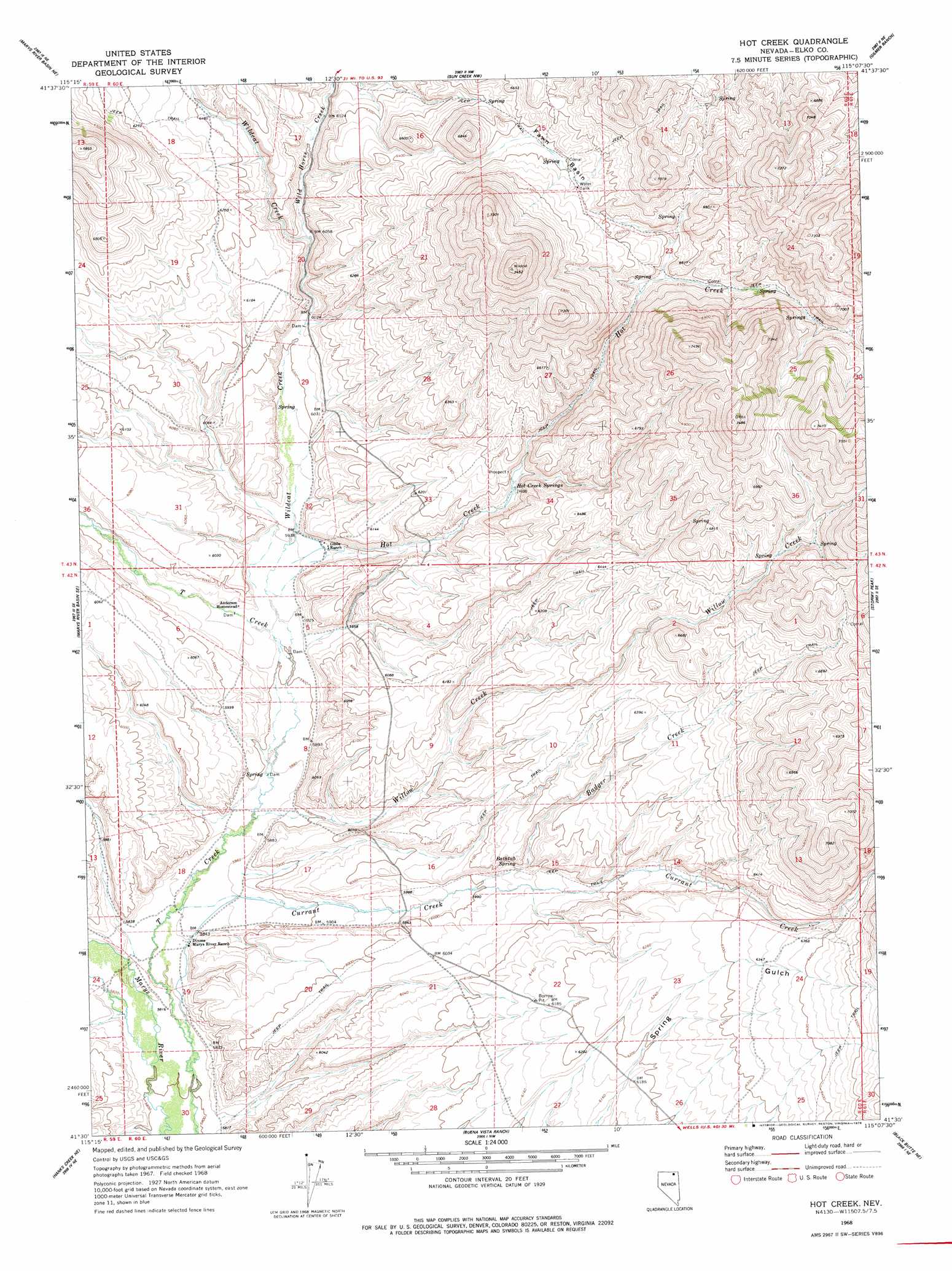
USGS Topo Quad 41115e2 - 1:24,000 scale
| Topo Map Name: | Hot Creek |
| USGS Topo Quad ID: | 41115e2 |
| Print Size: | ca. 21 1/4" wide x 27" high |
| Southeast Coordinates: | 41.5° N latitude / 115.125° W longitude |
| Map Center Coordinates: | 41.5625° N latitude / 115.1875° W longitude |
| U.S. State: | NV |
| Filename: | o41115e2.jpg |
| Download Map JPG Image: | Hot Creek topo map 1:24,000 scale |
| Map Type: | Topographic |
| Topo Series: | 7.5´ |
| Map Scale: | 1:24,000 |
| Source of Map Images: | United States Geological Survey (USGS) |
| Alternate Map Versions: |
Hot Creek NV 1968, updated 1972 Download PDF Buy paper map Hot Creek NV 1968, updated 1978 Download PDF Buy paper map Hot Creek NV 2012 Download PDF Buy paper map Hot Creek NV 2014 Download PDF Buy paper map |
1:24,000 Topo Quads surrounding Hot Creek
Jarbidge South |
Gods Pocket Peak |
Goat Creek |
Buckhorn Ridge |
Twin Meadows Ranch |
Marys River Basin Nw |
Marys River Basin Ne |
Sun Creek Nw |
Gilmer Ranch |
Hubbard Basin |
Charleston Reservoir |
Marys River Basin Se |
Hot Creek |
Stormy Peak |
Boies Reservoir |
Stag Mountain |
Hanks Creek Ne |
Buena Vista Ranch |
Black Butte Ne |
Loomis Mountain |
Hanks Creek Sw |
Hot Springs Creek |
Black Butte Sw |
Black Butte |
Summer Camp |
> Back to 41115e1 at 1:100,000 scale
> Back to 41114a1 at 1:250,000 scale
> Back to U.S. Topo Maps home
Hot Creek topo map: Gazetteer
Hot Creek: Basins
Fawn Basin elevation 2011m 6597′Hot Creek: Populated Places
Morton (historical) elevation 1818m 5964′Hot Creek: Post Offices
Morton Post Office (historical) elevation 1818m 5964′Hot Creek: Springs
Bathtub Spring elevation 1842m 6043′Hot Creek Springs elevation 1877m 6158′
Hot Creek: Streams
Badger Creek elevation 1828m 5997′Currant Creek elevation 1781m 5843′
Hot Creek elevation 1811m 5941′
Wild Horse Creek elevation 1844m 6049′
Wildcat Creek elevation 1797m 5895′
Willow Creek elevation 1787m 5862′
Hot Creek digital topo map on disk
Buy this Hot Creek topo map showing relief, roads, GPS coordinates and other geographical features, as a high-resolution digital map file on DVD: