Annie Creek Topo Map Nevada
To zoom in, hover over the map of Annie Creek
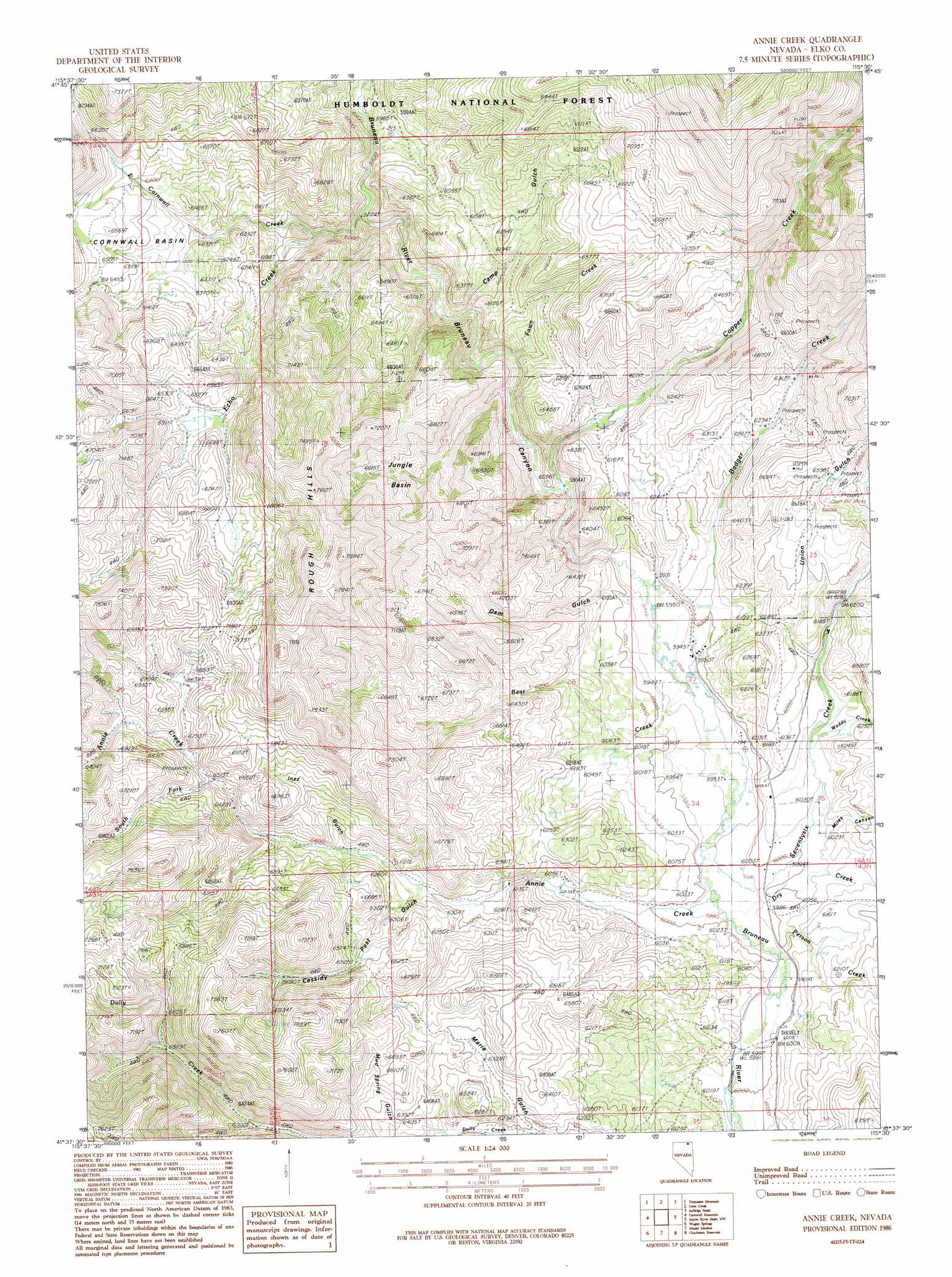
USGS Topo Quad 41115f5 - 1:24,000 scale
| Topo Map Name: | Annie Creek |
| USGS Topo Quad ID: | 41115f5 |
| Print Size: | ca. 21 1/4" wide x 27" high |
| Southeast Coordinates: | 41.625° N latitude / 115.5° W longitude |
| Map Center Coordinates: | 41.6875° N latitude / 115.5625° W longitude |
| U.S. State: | NV |
| Filename: | o41115f5.jpg |
| Download Map JPG Image: | Annie Creek topo map 1:24,000 scale |
| Map Type: | Topographic |
| Topo Series: | 7.5´ |
| Map Scale: | 1:24,000 |
| Source of Map Images: | United States Geological Survey (USGS) |
| Alternate Map Versions: |
Annie Creek NV 1986, updated 1987 Download PDF Buy paper map Annie Creek NV 2012 Download PDF Buy paper map Annie Creek NV 2014 Download PDF Buy paper map |
| FStopo: | US Forest Service topo Annie Creek is available: Download FStopo PDF Download FStopo TIF |
1:24,000 Topo Quads surrounding Annie Creek
Hicks Mountain |
Big Table |
Bearpaw Mountain |
Jarbidge North |
Robinson Creek |
Merritt Mountain |
Tennessee Mountain |
Coon Creek |
Jarbidge South |
Gods Pocket Peak |
Wild Horse |
Cornwall Mountain |
Annie Creek |
Marys River Basin Nw |
Marys River Basin Ne |
Delaware Creek |
Wagon Springs |
Mount Ichabod |
Charleston Reservoir |
Marys River Basin Se |
North Fork |
Double Mountain |
Devils Armchair |
Stag Mountain |
Hanks Creek Ne |
> Back to 41115e1 at 1:100,000 scale
> Back to 41114a1 at 1:250,000 scale
> Back to U.S. Topo Maps home
Annie Creek topo map: Gazetteer
Annie Creek: Basins
Cornwall Basin elevation 1915m 6282′Jungle Basin elevation 1977m 6486′
Annie Creek: Mines
McKnights Placer Mine elevation 1852m 6076′Annie Creek: Populated Places
Bayard (historical) elevation 1988m 6522′Charleston elevation 1852m 6076′
Annie Creek: Post Offices
Bayard Post Office elevation 1988m 6522′Charleston Post Office elevation 1852m 6076′
Annie Creek: Ranges
Rough Hills elevation 2377m 7798′Annie Creek: Springs
Mud Springs elevation 1948m 6391′Annie Creek: Streams
Annie Creek elevation 1822m 5977′Badger Creek elevation 1811m 5941′
Bear Creek elevation 1812m 5944′
Copper Creek elevation 1798m 5898′
Cornwall Creek elevation 1749m 5738′
Dry Creek elevation 1821m 5974′
Echo Creek elevation 1819m 5967′
Fawn Creek elevation 1786m 5859′
Person Creek elevation 1824m 5984′
Seventysix Creek elevation 1821m 5974′
South Fork Annie Creek elevation 1984m 6509′
Waddy Creek elevation 1853m 6079′
Annie Creek: Valleys
Camp Gulch elevation 1779m 5836′Cassidy Post Gulch elevation 1901m 6236′
Dam Gulch elevation 1820m 5971′
Inez Gulch elevation 1925m 6315′
Marie Gulch elevation 1892m 6207′
Miles Canyon elevation 1856m 6089′
Union Gulch elevation 1880m 6167′
Annie Creek digital topo map on disk
Buy this Annie Creek topo map showing relief, roads, GPS coordinates and other geographical features, as a high-resolution digital map file on DVD: