Merritt Mountain Topo Map Nevada
To zoom in, hover over the map of Merritt Mountain
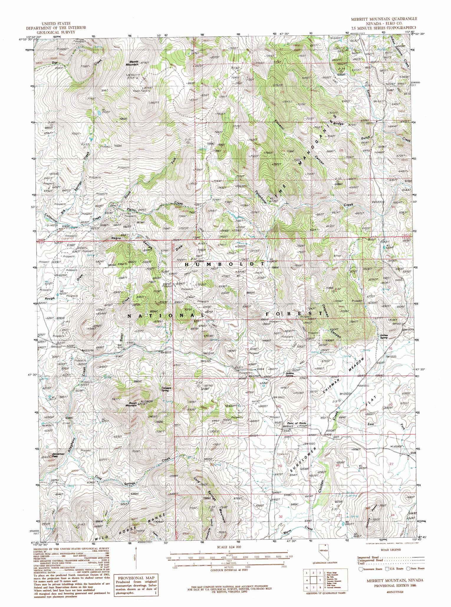
USGS Topo Quad 41115g7 - 1:24,000 scale
| Topo Map Name: | Merritt Mountain |
| USGS Topo Quad ID: | 41115g7 |
| Print Size: | ca. 21 1/4" wide x 27" high |
| Southeast Coordinates: | 41.75° N latitude / 115.75° W longitude |
| Map Center Coordinates: | 41.8125° N latitude / 115.8125° W longitude |
| U.S. State: | NV |
| Filename: | o41115g7.jpg |
| Download Map JPG Image: | Merritt Mountain topo map 1:24,000 scale |
| Map Type: | Topographic |
| Topo Series: | 7.5´ |
| Map Scale: | 1:24,000 |
| Source of Map Images: | United States Geological Survey (USGS) |
| Alternate Map Versions: |
Merritt Mountain NV 1986, updated 1987 Download PDF Buy paper map Merritt Mountain NV 2012 Download PDF Buy paper map Merritt Mountain NV 2014 Download PDF Buy paper map |
| FStopo: | US Forest Service topo Merritt Mountain is available: Download FStopo PDF Download FStopo TIF |
1:24,000 Topo Quads surrounding Merritt Mountain
Three Forks |
Indian Hay Meadows |
Black Leg Creek |
Triplet Butte |
Cowan Reservoir |
Owyhee |
Winter Ridge |
Hicks Mountain |
Big Table |
Bearpaw Mountain |
Ungina Wongo |
Mountain City |
Merritt Mountain |
Tennessee Mountain |
Coon Creek |
Maggie Summit |
Badger Creek |
Wild Horse |
Cornwall Mountain |
Annie Creek |
Chicken Creek Summit |
Mcafee Peak |
Delaware Creek |
Wagon Springs |
Mount Ichabod |
> Back to 41115e1 at 1:100,000 scale
> Back to 41114a1 at 1:250,000 scale
> Back to U.S. Topo Maps home
Merritt Mountain topo map: Gazetteer
Merritt Mountain: Flats
Chipman Meadow elevation 1987m 6519′Sunflower Flat elevation 2013m 6604′
Merritt Mountain: Populated Places
Point of Rocks elevation 2001m 6564′Merritt Mountain: Springs
Archies Spring elevation 2013m 6604′Jenkins Spring elevation 2024m 6640′
Transient Spring elevation 1993m 6538′
Merritt Mountain: Streams
Baker Creek elevation 1870m 6135′Big Springs Creek elevation 1881m 6171′
Cold Springs Creek elevation 1804m 5918′
East Fork Chicken Creek elevation 1976m 6482′
Negro George Creek elevation 1900m 6233′
Pixley Creek elevation 1935m 6348′
South Fork California Creek elevation 1881m 6171′
Merritt Mountain: Summits
Cold Springs Mountain elevation 2259m 7411′Jenkins Peaks elevation 2206m 7237′
Jenneman Peak elevation 1938m 6358′
Merritt Mountain elevation 2672m 8766′
Rough Mountain elevation 2267m 7437′
Merritt Mountain: Valleys
Bridge Gulch elevation 1909m 6263′Chipman Canyon elevation 1983m 6505′
Negro George Draw elevation 1906m 6253′
Vincenti Canyon elevation 1958m 6423′
Merritt Mountain digital topo map on disk
Buy this Merritt Mountain topo map showing relief, roads, GPS coordinates and other geographical features, as a high-resolution digital map file on DVD: