Water Pipe Canyon Topo Map Nevada
To zoom in, hover over the map of Water Pipe Canyon
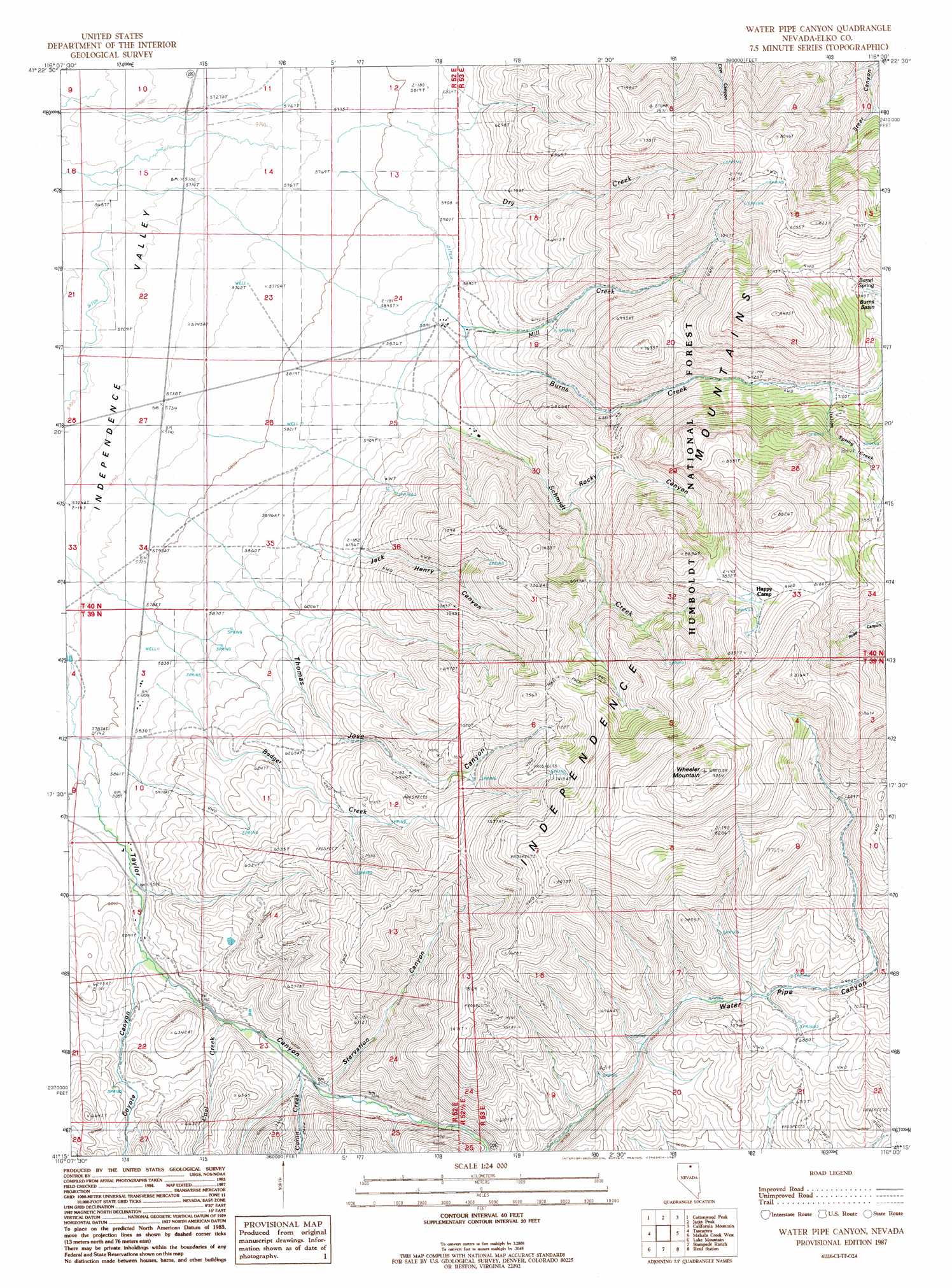
USGS Topo Quad 41116c1 - 1:24,000 scale
| Topo Map Name: | Water Pipe Canyon |
| USGS Topo Quad ID: | 41116c1 |
| Print Size: | ca. 21 1/4" wide x 27" high |
| Southeast Coordinates: | 41.25° N latitude / 116° W longitude |
| Map Center Coordinates: | 41.3125° N latitude / 116.0625° W longitude |
| U.S. State: | NV |
| Filename: | o41116c1.jpg |
| Download Map JPG Image: | Water Pipe Canyon topo map 1:24,000 scale |
| Map Type: | Topographic |
| Topo Series: | 7.5´ |
| Map Scale: | 1:24,000 |
| Source of Map Images: | United States Geological Survey (USGS) |
| Alternate Map Versions: |
Water Pipe Canyon NV 1987, updated 1987 Download PDF Buy paper map Water Pipe Canyon NV 2012 Download PDF Buy paper map Water Pipe Canyon NV 2015 Download PDF Buy paper map |
| FStopo: | US Forest Service topo Water Pipe Canyon is available: Download FStopo PDF Download FStopo TIF |
1:24,000 Topo Quads surrounding Water Pipe Canyon
Cornucopia Ridge |
Deep Creek |
Chicken Creek Summit |
Mcafee Peak |
Delaware Creek |
Big Cottonwood Canyon |
Cottonwood Peak |
Jacks Peak |
California Mountain |
North Fork |
Mount Blitzen |
Tuscarora |
Water Pipe Canyon |
Mahala Creek West |
Mahala Creek East |
Sugarloaf Butte |
Lake Mountain |
Stampede Ranch |
Reed Station |
Wieland Flat |
Beaver Peak |
Beaver Creek |
Blue Basin |
Singletree Creek |
Dinner Station |
> Back to 41116a1 at 1:100,000 scale
> Back to 41116a1 at 1:250,000 scale
> Back to U.S. Topo Maps home
Water Pipe Canyon topo map: Gazetteer
Water Pipe Canyon: Basins
Independence Valley elevation 1751m 5744′Water Pipe Canyon: Mines
Basin Burns Mine elevation 2489m 8166′Water Pipe Canyon: Springs
Barrel Spring elevation 2243m 7358′Willow Spring elevation 2090m 6856′
Water Pipe Canyon: Streams
Carlin Creek elevation 1836m 6023′Coal Creek elevation 1848m 6062′
Coyote Creek elevation 1802m 5912′
Dry Creek elevation 1818m 5964′
Italian Spring Creek elevation 2168m 7112′
Mill Creek elevation 1826m 5990′
Schmidt Creek elevation 1807m 5928′
Sixmile Creek elevation 1941m 6368′
Water Pipe Canyon: Summits
Wheeler Mountain elevation 2750m 9022′Water Pipe Canyon: Valleys
Coyote Canyon elevation 1806m 5925′Jack Henry Canyon elevation 1815m 5954′
Rocky Canyon elevation 1947m 6387′
Starvation Canyon elevation 1850m 6069′
Taylor Canyon elevation 1762m 5780′
Thomas Jose Canyon elevation 1772m 5813′
Water Pipe Canyon digital topo map on disk
Buy this Water Pipe Canyon topo map showing relief, roads, GPS coordinates and other geographical features, as a high-resolution digital map file on DVD: