Bull Run Reservoir Topo Map Nevada
To zoom in, hover over the map of Bull Run Reservoir
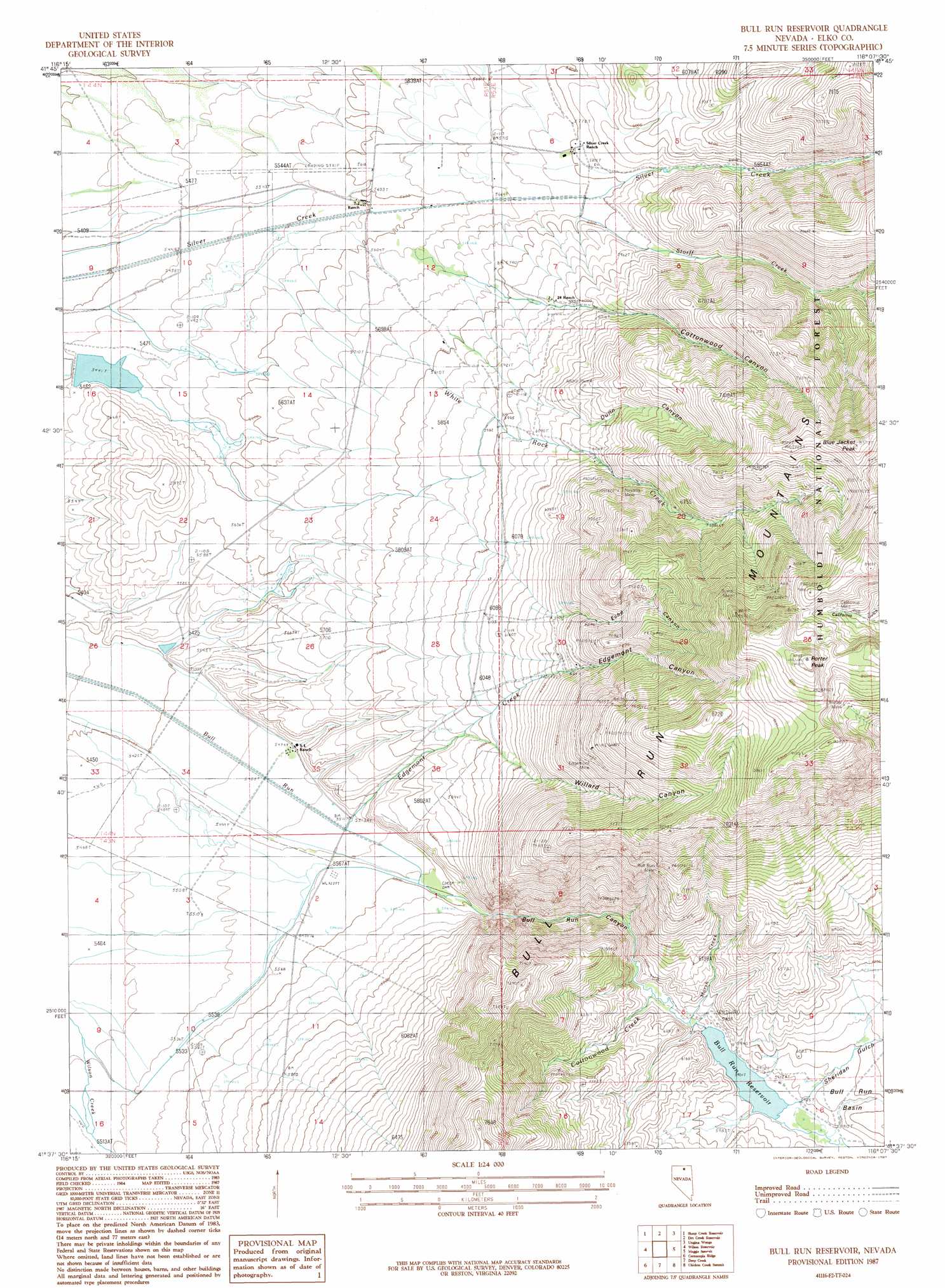
USGS Topo Quad 41116f2 - 1:24,000 scale
| Topo Map Name: | Bull Run Reservoir |
| USGS Topo Quad ID: | 41116f2 |
| Print Size: | ca. 21 1/4" wide x 27" high |
| Southeast Coordinates: | 41.625° N latitude / 116.125° W longitude |
| Map Center Coordinates: | 41.6875° N latitude / 116.1875° W longitude |
| U.S. State: | NV |
| Filename: | o41116f2.jpg |
| Download Map JPG Image: | Bull Run Reservoir topo map 1:24,000 scale |
| Map Type: | Topographic |
| Topo Series: | 7.5´ |
| Map Scale: | 1:24,000 |
| Source of Map Images: | United States Geological Survey (USGS) |
| Alternate Map Versions: |
Bull Run Reservoir NV 1987, updated 1987 Download PDF Buy paper map Bull Run Reservoir NV 2012 Download PDF Buy paper map Bull Run Reservoir NV 2014 Download PDF Buy paper map |
| FStopo: | US Forest Service topo Bull Run Reservoir is available: Download FStopo PDF Download FStopo TIF |
1:24,000 Topo Quads surrounding Bull Run Reservoir
Hat Peak |
Groundhog Reservoir |
The Point |
Owyhee |
Winter Ridge |
Peterson Table East |
Sheep Creek Reservoir |
Dry Creek Reservoir |
Ungina Wongo |
Mountain City |
Fourmile Butte |
Wilson Reservoir |
Bull Run Reservoir |
Maggie Summit |
Badger Creek |
I-L Ranch |
Cornucopia Ridge |
Deep Creek |
Chicken Creek Summit |
Mcafee Peak |
Red Cow Creek |
Big Cottonwood Canyon |
Cottonwood Peak |
Jacks Peak |
California Mountain |
> Back to 41116e1 at 1:100,000 scale
> Back to 41116a1 at 1:250,000 scale
> Back to U.S. Topo Maps home
Bull Run Reservoir topo map: Gazetteer
Bull Run Reservoir: Airports
Petan Ranch Airport elevation 1692m 5551′Bull Run Reservoir: Dams
Bull Run Dam elevation 1800m 5905′Round Mountain Reservoir Dam elevation 1659m 5442′
Bull Run Reservoir: Gaps
Devils Gap elevation 1722m 5649′Bull Run Reservoir: Mines
Blue Jacket Mine elevation 2474m 8116′Bull Run Mine elevation 2045m 6709′
Burns Mine elevation 2556m 8385′
California Mine elevation 2591m 8500′
Edgemont Mine elevation 2293m 7522′
Little Giant Lode elevation 2029m 6656′
Lucky Girl Group elevation 2141m 7024′
Montana Mine elevation 2141m 7024′
Monument Lode elevation 2424m 7952′
Nevada Mine elevation 2022m 6633′
North Star Lode elevation 2449m 8034′
Riddle Mine elevation 2632m 8635′
Sunrise Lode elevation 2496m 8188′
White Rock Mine elevation 2399m 7870′
Bull Run Reservoir: Populated Places
Echo elevation 2005m 6578′Excelsior (historical) elevation 1922m 6305′
White Rock (historical) elevation 1740m 5708′
Bull Run Reservoir: Post Offices
Edgemont Post Office elevation 2005m 6578′Excelsior Post Office elevation 1922m 6305′
White Rock Post Office elevation 1740m 5708′
Bull Run Reservoir: Reservoirs
Bull Run Reservoir elevation 1800m 5905′Bull Run Reservoir: Streams
Breakneck Creek elevation 1899m 6230′Cottonwood Creek elevation 1793m 5882′
Edgemont Creek elevation 1681m 5515′
Marsh Creek elevation 1793m 5882′
Ranch Creek elevation 1722m 5649′
Storff Creek elevation 1704m 5590′
White Rock Creek elevation 1681m 5515′
Bull Run Reservoir: Summits
Blue Jacket Peak elevation 2573m 8441′Porter Peak elevation 2791m 9156′
Bull Run Reservoir: Valleys
Bull Run Canyon elevation 1694m 5557′Cottonwood Canyon elevation 1703m 5587′
Dunn Canyon elevation 1721m 5646′
Echo Canyon elevation 1913m 6276′
Edgemont Canyon elevation 1681m 5515′
Sheridan Gulch elevation 1802m 5912′
Willard Canyon elevation 1804m 5918′
Bull Run Reservoir digital topo map on disk
Buy this Bull Run Reservoir topo map showing relief, roads, GPS coordinates and other geographical features, as a high-resolution digital map file on DVD: