Silver State Draw Topo Map Nevada
To zoom in, hover over the map of Silver State Draw
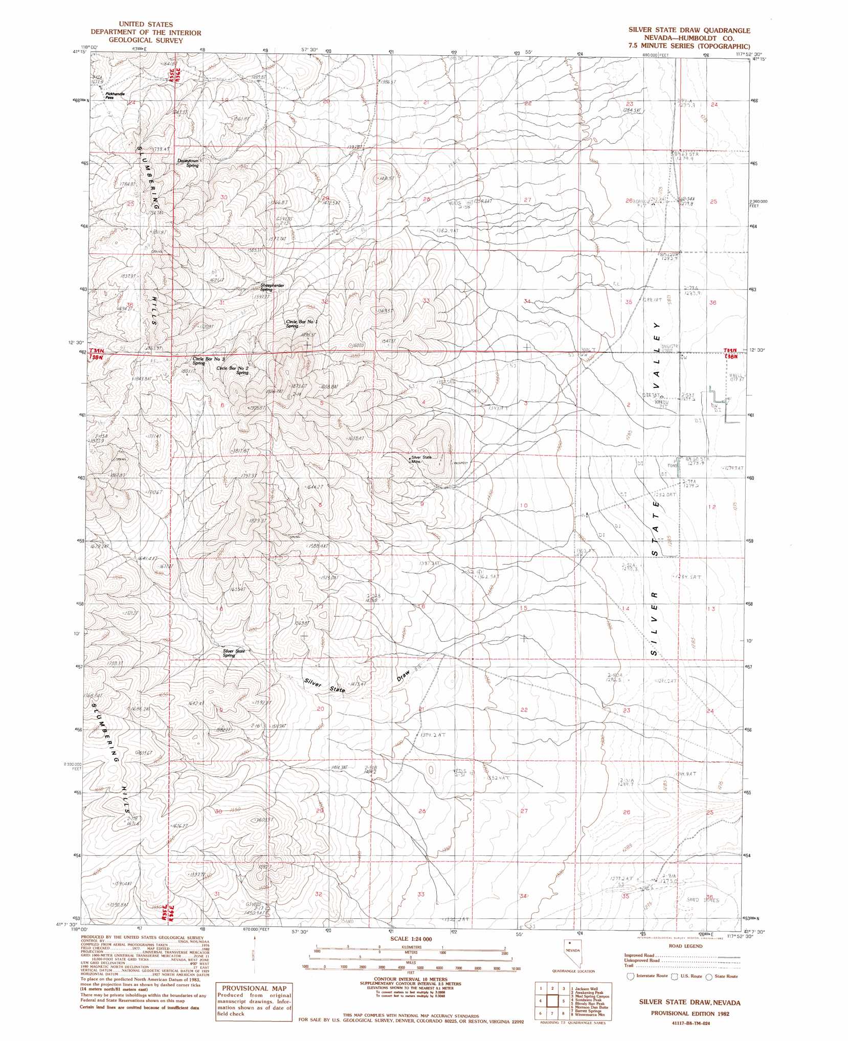
USGS Topo Quad 41117b8 - 1:24,000 scale
| Topo Map Name: | Silver State Draw |
| USGS Topo Quad ID: | 41117b8 |
| Print Size: | ca. 21 1/4" wide x 27" high |
| Southeast Coordinates: | 41.125° N latitude / 117.875° W longitude |
| Map Center Coordinates: | 41.1875° N latitude / 117.9375° W longitude |
| U.S. State: | NV |
| Filename: | o41117b8.jpg |
| Download Map JPG Image: | Silver State Draw topo map 1:24,000 scale |
| Map Type: | Topographic |
| Topo Series: | 7.5´ |
| Map Scale: | 1:24,000 |
| Source of Map Images: | United States Geological Survey (USGS) |
| Alternate Map Versions: |
Silver State Draw NV 1982, updated 1982 Download PDF Buy paper map Silver State Draw NV 2011 Download PDF Buy paper map Silver State Draw NV 2015 Download PDF Buy paper map |
1:24,000 Topo Quads surrounding Silver State Draw
Bottle Creek Slough Nw |
Sod House |
Gallagher Flat |
Andorno Ranch |
Five Fingers |
Bottle Creek Slough Sw |
Jackson Well |
Awakening Peak |
Mud Spring Canyon |
Paradise Well |
Presnel Well |
Sombrero Peak |
Silver State Draw |
Bloody Run Peak |
China Garden |
Lay Waterhole |
Mormon Dan Butte |
Barrett Springs |
Winnemucca Mountain |
Weso |
Gaskell |
Pronto |
Rose Creek |
Winnemucca West |
Winnemucca East |
> Back to 41117a1 at 1:100,000 scale
> Back to 41116a1 at 1:250,000 scale
> Back to U.S. Topo Maps home
Silver State Draw topo map: Gazetteer
Silver State Draw: Arroyos
Silver State Draw elevation 1381m 4530′Silver State Draw: Gaps
Pickhandle Pass elevation 1680m 5511′Silver State Draw: Mines
Silver State Mine elevation 1461m 4793′Silver State Draw: Ranges
Slumbering Hills elevation 1772m 5813′Silver State Draw: Springs
Circle Bar Number 1 Spring elevation 1589m 5213′Circle Bar Number 2 Spring elevation 1661m 5449′
Circle Bar Number 3 Spring elevation 1714m 5623′
Daveytown Spring elevation 1562m 5124′
Sheepherder Spring elevation 1526m 5006′
Silver State Spring elevation 1526m 5006′
Wilder Spring elevation 1410m 4625′
Silver State Draw: Summits
Squaw Peak elevation 1481m 4858′Silver State Draw digital topo map on disk
Buy this Silver State Draw topo map showing relief, roads, GPS coordinates and other geographical features, as a high-resolution digital map file on DVD: