Hardscrabble Topo Map Nevada
To zoom in, hover over the map of Hardscrabble
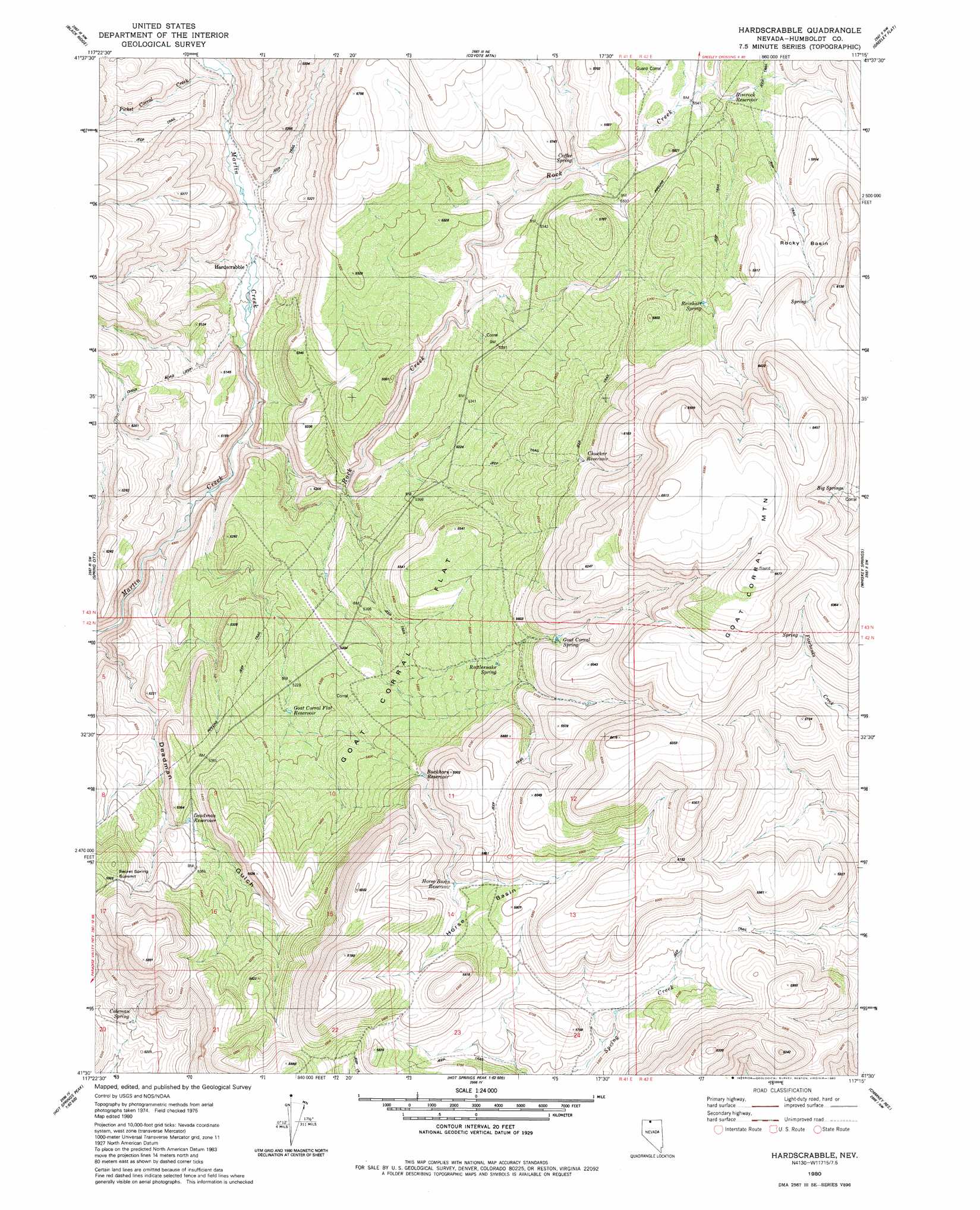
USGS Topo Quad 41117e3 - 1:24,000 scale
| Topo Map Name: | Hardscrabble |
| USGS Topo Quad ID: | 41117e3 |
| Print Size: | ca. 21 1/4" wide x 27" high |
| Southeast Coordinates: | 41.5° N latitude / 117.25° W longitude |
| Map Center Coordinates: | 41.5625° N latitude / 117.3125° W longitude |
| U.S. State: | NV |
| Filename: | o41117e3.jpg |
| Download Map JPG Image: | Hardscrabble topo map 1:24,000 scale |
| Map Type: | Topographic |
| Topo Series: | 7.5´ |
| Map Scale: | 1:24,000 |
| Source of Map Images: | United States Geological Survey (USGS) |
| Alternate Map Versions: |
Hardscrabble NV 1980, updated 1980 Download PDF Buy paper map Hardscrabble NV 2011 Download PDF Buy paper map Hardscrabble NV 2015 Download PDF Buy paper map |
1:24,000 Topo Quads surrounding Hardscrabble
Buckskin Mountain |
Holloway Meadows |
Capitol Peak |
Maiden Butte |
Maiden Butte Se |
Hinkey Summit |
Black Ridge |
Coyote Mountain |
Greeley Flat |
Button Lake |
Mullinix Creek |
Spring City |
Hardscrabble |
Whiskey Springs |
Greeley Flat Se |
Paradise Valley |
Little Poverty |
Fairbanks Canyon |
Chimney Reservoir |
Layton Spring |
Willow Point |
Hot Springs Peak |
Eden Valley |
Dry Hills North |
Kenny Creek |
> Back to 41117e1 at 1:100,000 scale
> Back to 41116a1 at 1:250,000 scale
> Back to U.S. Topo Maps home
Hardscrabble topo map: Gazetteer
Hardscrabble: Basins
Horse Basin elevation 1758m 5767′Rocky Basin elevation 1767m 5797′
Hardscrabble: Flats
Goat Corral Flat elevation 1640m 5380′Hardscrabble: Gaps
Secret Spring Summit elevation 1686m 5531′Hardscrabble: Ranges
Ararat Hills elevation 1740m 5708′Hardscrabble: Reservoirs
Buckhorn Reservoir elevation 1675m 5495′Chuckar Reservoir elevation 1735m 5692′
Deadman Reservoir elevation 1605m 5265′
Goat Corral Flat Reservoir elevation 1602m 5255′
Horse Basin Reservoir elevation 1738m 5702′
Rimrock Reservoir elevation 1706m 5597′
Hardscrabble: Springs
Big Springs elevation 1872m 6141′Coffee Spring elevation 1670m 5479′
Coleman Spring elevation 1596m 5236′
Goat Corral Spring elevation 1745m 5725′
Rattlesnake Spring elevation 1689m 5541′
Reinhart Spring elevation 1762m 5780′
Hardscrabble: Streams
Picket Corral Creek elevation 1539m 5049′Rock Creek elevation 1483m 4865′
Hardscrabble: Summits
Goat Corral Mountain elevation 2003m 6571′Hardscrabble digital topo map on disk
Buy this Hardscrabble topo map showing relief, roads, GPS coordinates and other geographical features, as a high-resolution digital map file on DVD: