Mcconnell Peak Topo Map Nevada
To zoom in, hover over the map of Mcconnell Peak
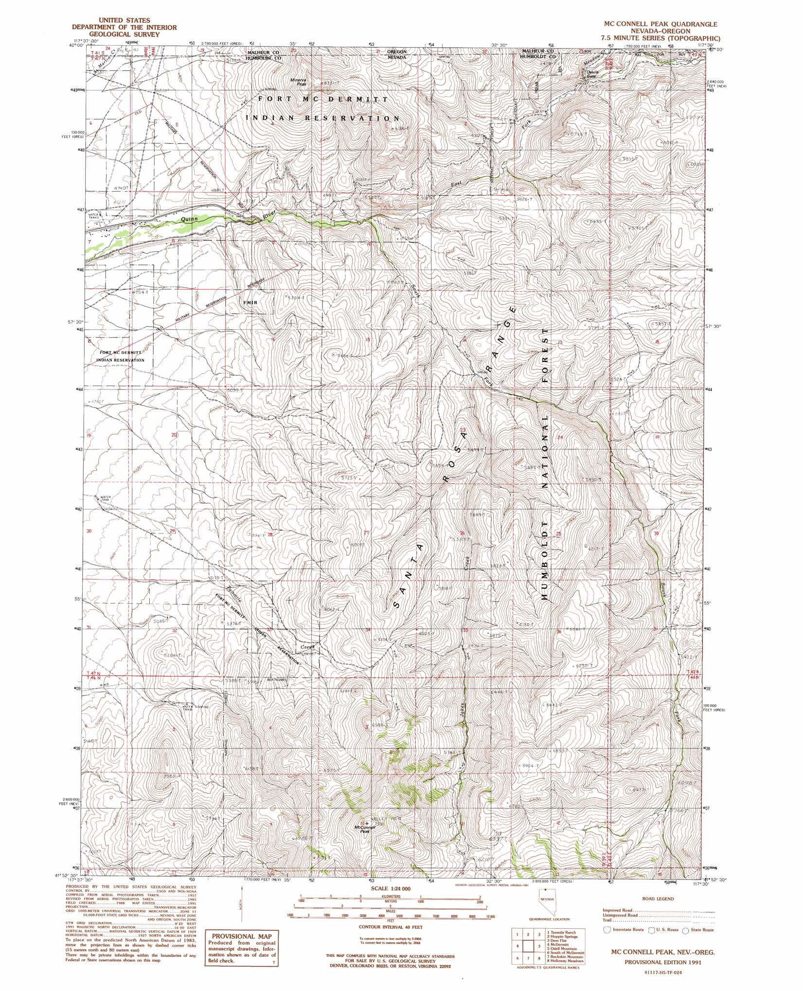
USGS Topo Quad 41117h5 - 1:24,000 scale
| Topo Map Name: | Mcconnell Peak |
| USGS Topo Quad ID: | 41117h5 |
| Print Size: | ca. 21 1/4" wide x 27" high |
| Southeast Coordinates: | 41.875° N latitude / 117.5° W longitude |
| Map Center Coordinates: | 41.9375° N latitude / 117.5625° W longitude |
| U.S. States: | NV, OR |
| Filename: | o41117h5.jpg |
| Download Map JPG Image: | Mcconnell Peak topo map 1:24,000 scale |
| Map Type: | Topographic |
| Topo Series: | 7.5´ |
| Map Scale: | 1:24,000 |
| Source of Map Images: | United States Geological Survey (USGS) |
| Alternate Map Versions: |
McConnell Peak NV 1991, updated 1991 Download PDF Buy paper map McConnell Peak NV 2011 Download PDF Buy paper map McConnell Peak NV 2015 Download PDF Buy paper map |
| FStopo: | US Forest Service topo McConnell Peak is available: Download FStopo PDF Download FStopo TIF |
1:24,000 Topo Quads surrounding Mcconnell Peak
Bowden Waterhole |
Jackson Summit |
Grasshopper Flat South |
Chipmunk Basin |
Guadalupe Meadows |
Boghole Spring |
Tenmile Ranch |
Hoppin Springs |
Deer Flat |
Oregon Butte |
Cordero Mine |
Mcdermitt |
Mcconnell Peak |
Odell Mountain |
Mahogany Spring |
Hoppin Peaks |
South Of Mcdermitt |
Buckskin Mountain |
Holloway Meadows |
Capitol Peak |
Willow Creek Ranch |
White Rock Canyon |
Hinkey Summit |
Black Ridge |
Coyote Mountain |
> Back to 41117e1 at 1:100,000 scale
> Back to 41116a1 at 1:250,000 scale
> Back to U.S. Topo Maps home
Mcconnell Peak topo map: Gazetteer
Mcconnell Peak: Gaps
Devils Gate elevation 1522m 4993′Mcconnell Peak: Post Offices
Fort McDermitt Post Office (historical) elevation 1414m 4639′Mcconnell Peak: Streams
Chicken Creek elevation 1655m 5429′East Fork Quinn River elevation 1440m 4724′
East Fork Quinn River elevation 1440m 4724′
Jakes Creek elevation 1493m 4898′
Long Meadow Creek elevation 1505m 4937′
South Fork Quinn River elevation 1440m 4724′
Mcconnell Peak: Summits
McConnell Peak elevation 2285m 7496′Minerva Peak elevation 1912m 6272′
Mcconnell Peak digital topo map on disk
Buy this Mcconnell Peak topo map showing relief, roads, GPS coordinates and other geographical features, as a high-resolution digital map file on DVD: