King Lear Peak Topo Map Nevada
To zoom in, hover over the map of King Lear Peak
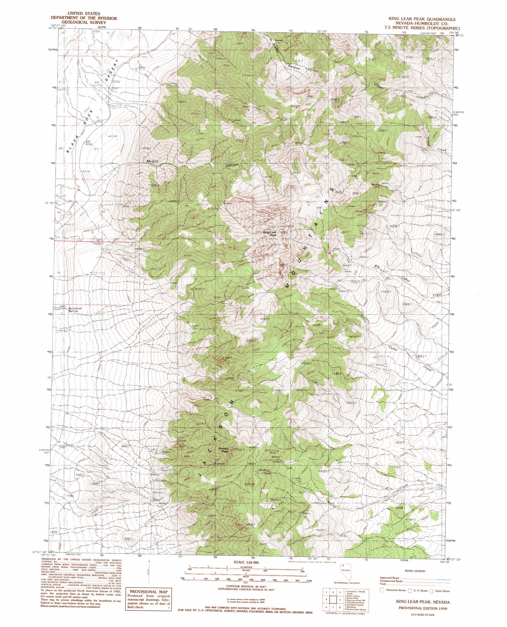
USGS Topo Quad 41118b5 - 1:24,000 scale
| Topo Map Name: | King Lear Peak |
| USGS Topo Quad ID: | 41118b5 |
| Print Size: | ca. 21 1/4" wide x 27" high |
| Southeast Coordinates: | 41.125° N latitude / 118.5° W longitude |
| Map Center Coordinates: | 41.1875° N latitude / 118.5625° W longitude |
| U.S. State: | NV |
| Filename: | o41118b5.jpg |
| Download Map JPG Image: | King Lear Peak topo map 1:24,000 scale |
| Map Type: | Topographic |
| Topo Series: | 7.5´ |
| Map Scale: | 1:24,000 |
| Source of Map Images: | United States Geological Survey (USGS) |
| Alternate Map Versions: |
King Lear Peak NV 1990, updated 1990 Download PDF Buy paper map King Lear Peak NV 2011 Download PDF Buy paper map King Lear Peak NV 2015 Download PDF Buy paper map |
1:24,000 Topo Quads surrounding King Lear Peak
Battle Creek Ranch |
Leonard Cr Slough North |
Deer Creek Slough |
Deer Creek Peak |
Bottle Hill |
Pinto Mountain |
Leonard Cr Slough South |
Hobo Canyon |
Parrot Peak |
Bottle Creek Ranch |
Crowbar Spring |
King Lear Peak Nw |
King Lear Peak |
Schoolhouse Butte |
Dry Hills |
Pidgeon Spring Se |
Salt Water Spring |
Red Butte |
Donna Schee Spring |
Donna Schee Peak |
Rabbithole Ne |
Floka |
Sugarloaf Knob |
Jungo |
Jungo Ne |
> Back to 41118a1 at 1:100,000 scale
> Back to 41118a1 at 1:250,000 scale
> Back to U.S. Topo Maps home
King Lear Peak topo map: Gazetteer
King Lear Peak: Mines
Red Ball Mines elevation 1814m 5951′Red Boy Mine elevation 1927m 6322′
King Lear Peak: Springs
Buckbrush Springs elevation 1264m 4146′King Lear Peak: Summits
King Lear Peak elevation 2695m 8841′Navajo Peak elevation 2352m 7716′
King Lear Peak: Valleys
McGill Canyon elevation 1227m 4025′King Lear Peak digital topo map on disk
Buy this King Lear Peak topo map showing relief, roads, GPS coordinates and other geographical features, as a high-resolution digital map file on DVD: