Idaho Canyon Spring Topo Map Nevada
To zoom in, hover over the map of Idaho Canyon Spring
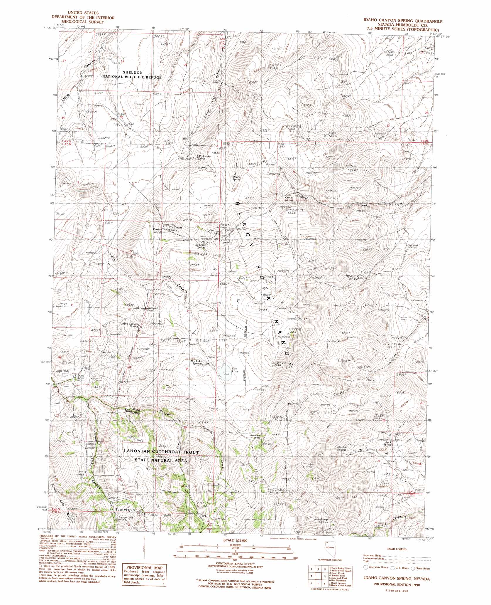
USGS Topo Quad 41118e8 - 1:24,000 scale
| Topo Map Name: | Idaho Canyon Spring |
| USGS Topo Quad ID: | 41118e8 |
| Print Size: | ca. 21 1/4" wide x 27" high |
| Southeast Coordinates: | 41.5° N latitude / 118.875° W longitude |
| Map Center Coordinates: | 41.5625° N latitude / 118.9375° W longitude |
| U.S. State: | NV |
| Filename: | o41118e8.jpg |
| Download Map JPG Image: | Idaho Canyon Spring topo map 1:24,000 scale |
| Map Type: | Topographic |
| Topo Series: | 7.5´ |
| Map Scale: | 1:24,000 |
| Source of Map Images: | United States Geological Survey (USGS) |
| Alternate Map Versions: |
Idaho Canyon Spring NV 1990, updated 1990 Download PDF Buy paper map Idaho Canyon Spring NV 2011 Download PDF Buy paper map Idaho Canyon Spring NV 2015 Download PDF Buy paper map |
1:24,000 Topo Quads surrounding Idaho Canyon Spring
Gooch Lake |
Virgin Valley |
Mcgee Mountain |
Alder Creek Ranch |
Vicksburg Canyon |
Alkali Peak |
Rock Spring Table |
Knott Creek Ranch |
Knott Creek |
Duffer Peak |
Bear Buttes |
Summit Lake |
Idaho Canyon Spring |
New York Peak |
Bishop Peak |
Soldier Meadow |
Red Mountain |
Burnt Springs |
Battle Creek Ranch |
Leonard Cr Slough North |
Mud Meadow |
Big Mountain |
Paiute Meadows |
Pinto Mountain |
Leonard Cr Slough South |
> Back to 41118e1 at 1:100,000 scale
> Back to 41118a1 at 1:250,000 scale
> Back to U.S. Topo Maps home
Idaho Canyon Spring topo map: Gazetteer
Idaho Canyon Spring: Bends
Horseshoe Bend elevation 2139m 7017′Idaho Canyon Spring: Flats
Buck Pasture elevation 2147m 7043′Idaho Canyon Spring: Lakes
Dry Lake elevation 2169m 7116′Idaho Canyon Spring: Parks
Lahontan Cutthroat Trout Natural Area elevation 2220m 7283′Idaho Canyon Spring: Springs
Craine Spring elevation 1858m 6095′Dry Lake Springs elevation 2178m 7145′
Idaho Canyon Spring elevation 2066m 6778′
McCully Spring elevation 1794m 5885′
Middle Spring elevation 1996m 6548′
Parman Spring elevation 2008m 6587′
Rock Spring elevation 1754m 5754′
Santa Claus Spring elevation 1911m 6269′
Summit Spring elevation 2063m 6768′
Tin Trough Spring elevation 2021m 6630′
Wheeler Springs elevation 1840m 6036′
Woodcamp Springs elevation 1994m 6541′
Idaho Canyon Spring: Streams
Pole Creek elevation 2033m 6669′South Fork Mahogany Creek elevation 1957m 6420′
Idaho Canyon Spring: Summits
Summit Lake Mountain elevation 2464m 8083′Idaho Canyon Spring: Valleys
Summer Camp Canyon elevation 1957m 6420′Wood Canyon elevation 1954m 6410′
Idaho Canyon Spring digital topo map on disk
Buy this Idaho Canyon Spring topo map showing relief, roads, GPS coordinates and other geographical features, as a high-resolution digital map file on DVD: