Mcgee Mountain Topo Map Nevada
To zoom in, hover over the map of Mcgee Mountain
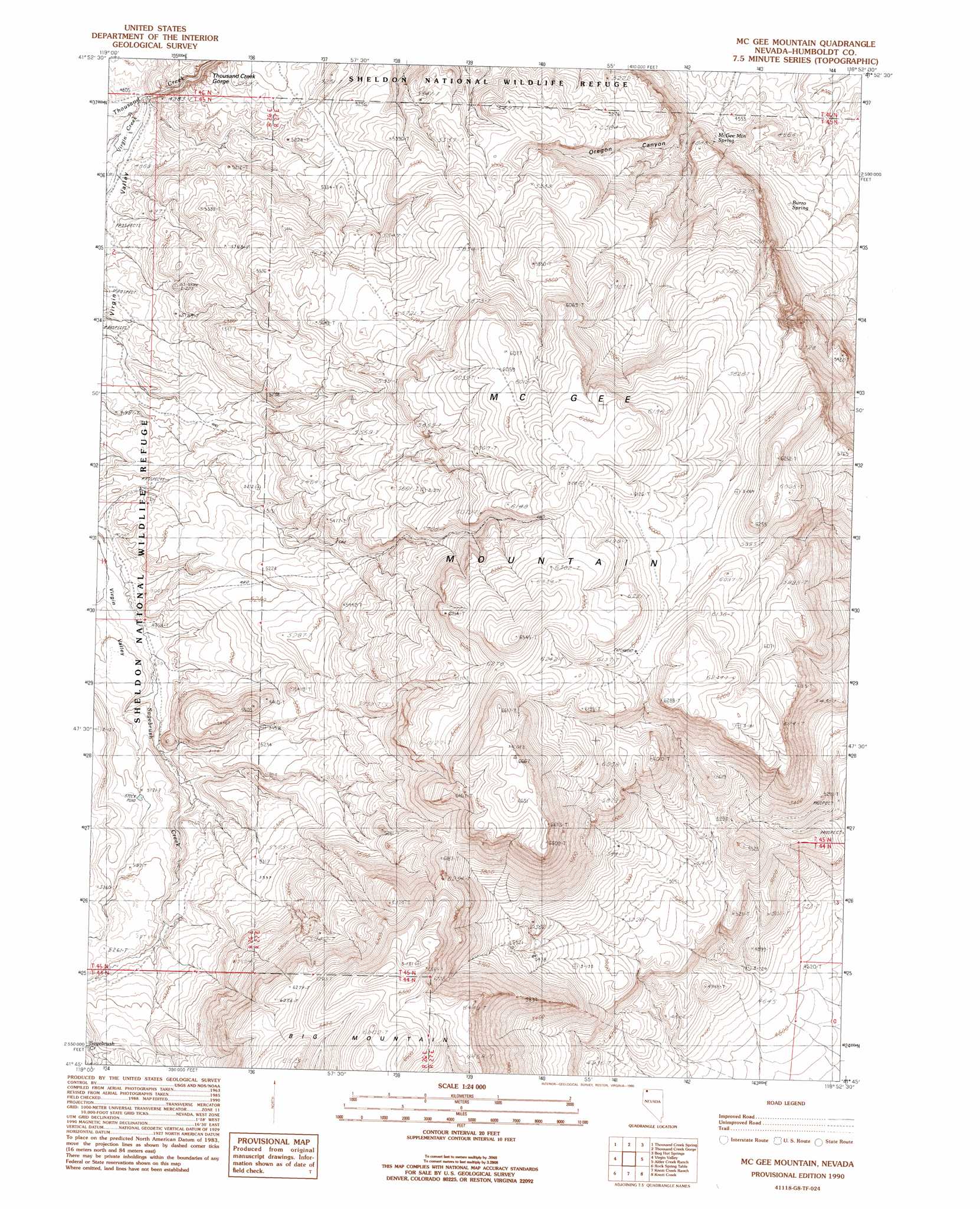
USGS Topo Quad 41118g8 - 1:24,000 scale
| Topo Map Name: | Mcgee Mountain |
| USGS Topo Quad ID: | 41118g8 |
| Print Size: | ca. 21 1/4" wide x 27" high |
| Southeast Coordinates: | 41.75° N latitude / 118.875° W longitude |
| Map Center Coordinates: | 41.8125° N latitude / 118.9375° W longitude |
| U.S. State: | NV |
| Filename: | o41118g8.jpg |
| Download Map JPG Image: | Mcgee Mountain topo map 1:24,000 scale |
| Map Type: | Topographic |
| Topo Series: | 7.5´ |
| Map Scale: | 1:24,000 |
| Source of Map Images: | United States Geological Survey (USGS) |
| Alternate Map Versions: |
McGee Mountain NV 1990, updated 1990 Download PDF Buy paper map McGhee Mountain NV 2011 Download PDF Buy paper map McGhee Mountain NV 2015 Download PDF Buy paper map |
1:24,000 Topo Quads surrounding Mcgee Mountain
Acty Mountain |
Hawks Mountain |
Black Rock Springs |
Oregon End Table |
Van Horn Basin |
Big Spring Butte |
Thousand Creek Spring |
Thousand Creek Gorge |
Bog Hot Springs |
Denio |
Gooch Lake |
Virgin Valley |
Mcgee Mountain |
Alder Creek Ranch |
Vicksburg Canyon |
Alkali Peak |
Rock Spring Table |
Knott Creek Ranch |
Knott Creek |
Duffer Peak |
Bear Buttes |
Summit Lake |
Idaho Canyon Spring |
New York Peak |
Bishop Peak |
> Back to 41118e1 at 1:100,000 scale
> Back to 41118a1 at 1:250,000 scale
> Back to U.S. Topo Maps home
Mcgee Mountain topo map: Gazetteer
Mcgee Mountain: Dams
Thousand Creek Dam elevation 1465m 4806′Mcgee Mountain: Springs
Burro Spring elevation 1447m 4747′McGhee Mountain Spring elevation 1413m 4635′
Mcgee Mountain: Streams
Virgin Creek elevation 1479m 4852′Mcgee Mountain: Summits
McGhee Mountain elevation 2007m 6584′Mcgee Mountain: Trails
McGee Grade elevation 1562m 5124′Mcgee Mountain: Valleys
Oregon Canyon elevation 1386m 4547′Mcgee Mountain digital topo map on disk
Buy this Mcgee Mountain topo map showing relief, roads, GPS coordinates and other geographical features, as a high-resolution digital map file on DVD: