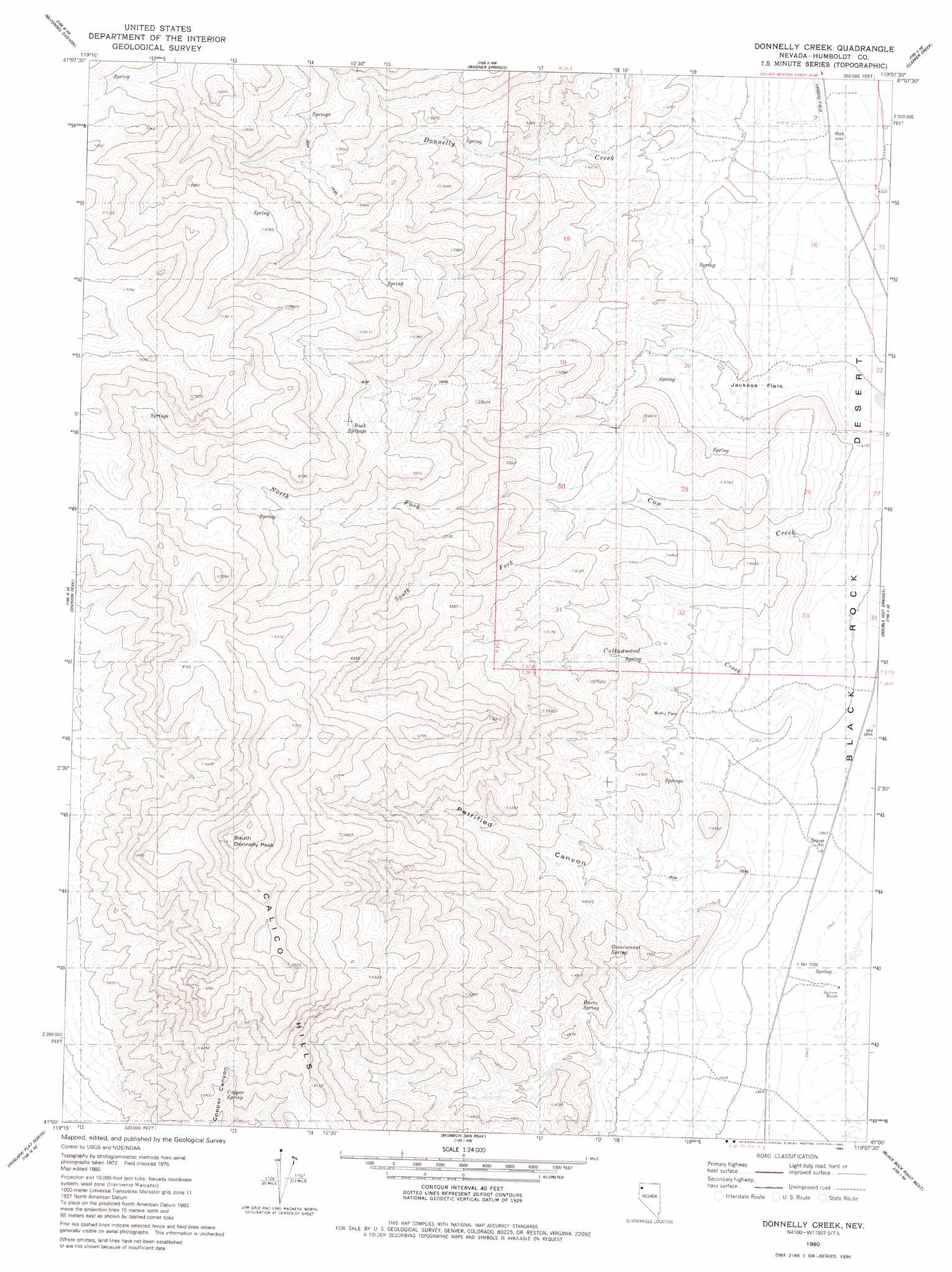
Donnelly Creek Topo Map Nevada
To zoom in, hover over the map of Donnelly Creek
USGS Topo Quad 41119a2 - 1:24,000 scale
| Topo Map Name: | Donnelly Creek |
| USGS Topo Quad ID: | 41119a2 |
| Print Size: | ca. 21 1/4" wide x 27" high |
| Southeast Coordinates: | 41° N latitude / 119.125° W longitude |
| Map Center Coordinates: | 41.0625° N latitude / 119.1875° W longitude |
| U.S. State: | NV |
| Filename: | o41119a2.jpg |
| Download Map JPG Image: | Donnelly Creek topo map 1:24,000 scale |
| Map Type: | Topographic |
| Topo Series: | 7.5´ |
| Map Scale: | 1:24,000 |
| Source of Map Images: | United States Geological Survey (USGS) |
| Alternate Map Versions: |
Donnelly Creek NV 1980, updated 1980 Download PDF Buy paper map Donnelly Creek NV 2011 Download PDF Buy paper map Donnelly Creek NV 2015 Download PDF Buy paper map |
1:24,000 Topo Quads surrounding Donnelly Creek
Mahogany Mountain |
High Rock Lake |
Mud Meadow |
Big Mountain |
Paiute Meadows |
Butte Spring |
Mcconnel Canyon |
Wagner Springs |
Clapper Creek |
Pidgeon Spring |
Leadville |
Division Peak |
Donnelly Creek |
Double Hot Springs |
Pidgeon Spring Sw |
Melody Mountain |
Hualapai Flat North |
Mormon Dan Peak |
Black Rock Point West |
Black Rock Point East |
The Banjo |
Hualapai Flat South |
Trego |
Trego Hot Springs |
Cholona |
> Back to 41119a1 at 1:100,000 scale
> Back to 41118a1 at 1:250,000 scale
> Back to U.S. Topo Maps home
Donnelly Creek topo map: Gazetteer
Donnelly Creek: Airports
Parman Landing Strip elevation 1232m 4041′Soldier Meadow Number Two Airport elevation 1235m 4051′
Donnelly Creek: Flats
Jackass Flats elevation 1262m 4140′Donnelly Creek: Springs
Buck Springs elevation 1801m 5908′Burro Spring elevation 1370m 4494′
Copper Spring elevation 1746m 5728′
Government Spring elevation 1383m 4537′
Sheep Spring elevation 1320m 4330′
Donnelly Creek: Streams
Cottonwood Creek elevation 1216m 3989′North Fork Cow Creek elevation 1428m 4685′
South Fork Cow Creek elevation 1428m 4685′
Donnelly Creek: Summits
South Donnelly Peak elevation 2347m 7700′Donnelly Creek: Valleys
Petrified Canyon elevation 1342m 4402′Donnelly Creek digital topo map on disk
Buy this Donnelly Creek topo map showing relief, roads, GPS coordinates and other geographical features, as a high-resolution digital map file on DVD: