Bear Buttes Topo Map Nevada
To zoom in, hover over the map of Bear Buttes
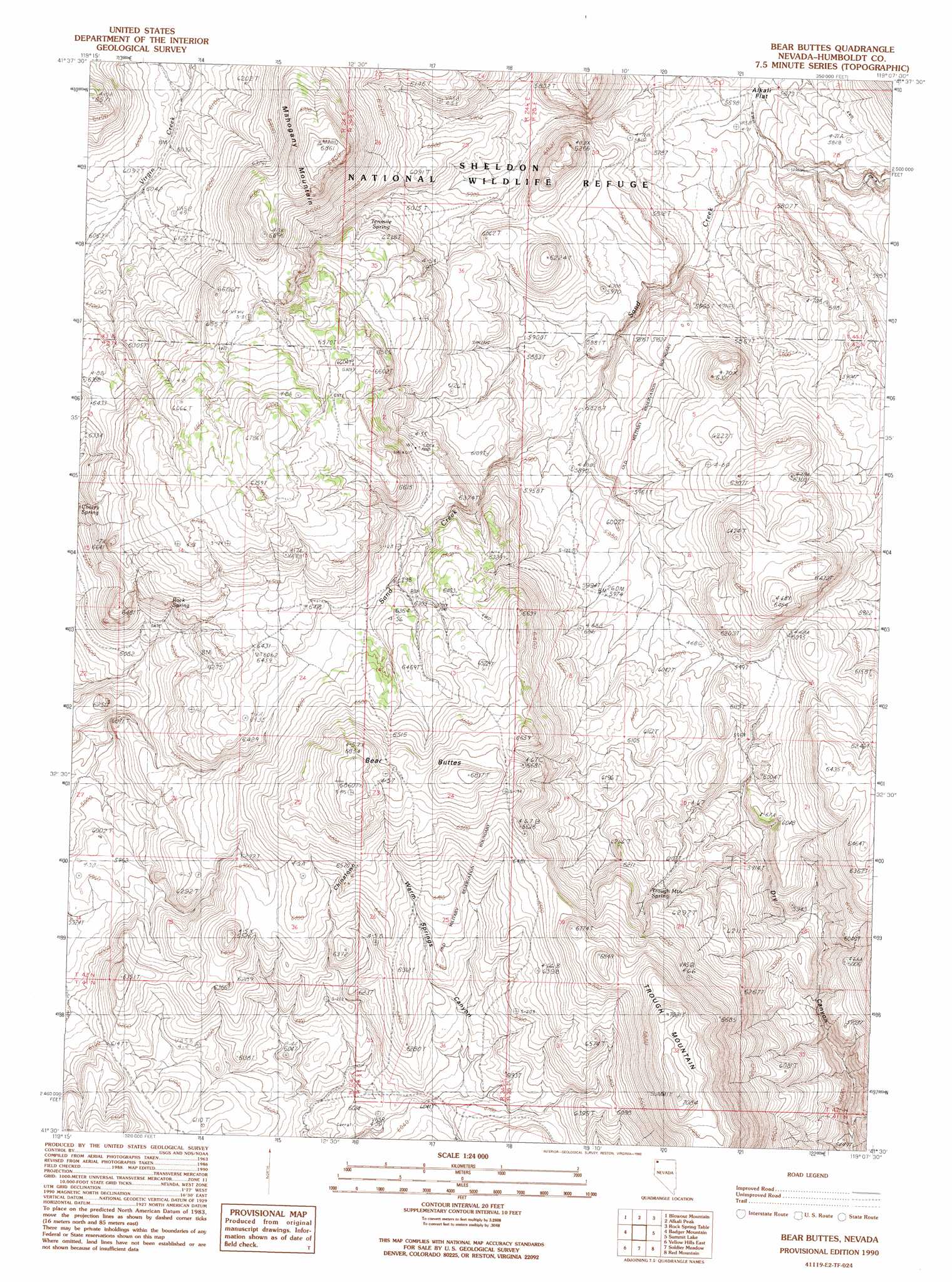
USGS Topo Quad 41119e2 - 1:24,000 scale
| Topo Map Name: | Bear Buttes |
| USGS Topo Quad ID: | 41119e2 |
| Print Size: | ca. 21 1/4" wide x 27" high |
| Southeast Coordinates: | 41.5° N latitude / 119.125° W longitude |
| Map Center Coordinates: | 41.5625° N latitude / 119.1875° W longitude |
| U.S. State: | NV |
| Filename: | o41119e2.jpg |
| Download Map JPG Image: | Bear Buttes topo map 1:24,000 scale |
| Map Type: | Topographic |
| Topo Series: | 7.5´ |
| Map Scale: | 1:24,000 |
| Source of Map Images: | United States Geological Survey (USGS) |
| Alternate Map Versions: |
Bear Buttes NV 1990, updated 1990 Download PDF Buy paper map Bear Buttes NV 2011 Download PDF Buy paper map Bear Buttes NV 2015 Download PDF Buy paper map |
1:24,000 Topo Quads surrounding Bear Buttes
Swan Lake |
Catnip Mountain Se |
Gooch Lake |
Virgin Valley |
Mcgee Mountain |
Badger Mountain Nw |
Blowout Mountain |
Alkali Peak |
Rock Spring Table |
Knott Creek Ranch |
Nut Mountain |
Badger Mountain Se |
Bear Buttes |
Summit Lake |
Idaho Canyon Spring |
Yellow Hills West |
Yellow Hills East |
Soldier Meadow |
Red Mountain |
Burnt Springs |
Mahogany Mountain |
High Rock Lake |
Mud Meadow |
Big Mountain |
Paiute Meadows |
> Back to 41119e1 at 1:100,000 scale
> Back to 41118a1 at 1:250,000 scale
> Back to U.S. Topo Maps home
Bear Buttes topo map: Gazetteer
Bear Buttes: Parks
Santa Rosa State Game Refuge elevation 1831m 6007′Bear Buttes: Populated Places
Chinatown elevation 1994m 6541′Bear Buttes: Ranges
High Rock Canyon Hills elevation 1808m 5931′Bear Buttes: Springs
Rock Spring elevation 1905m 6250′Tenmile Spring elevation 1857m 6092′
Trough Mountain Spring elevation 1896m 6220′
Bear Buttes: Summits
Bear Buttes elevation 2093m 6866′Mahogany Mountain elevation 2093m 6866′
Trough Mountain elevation 2160m 7086′
Bear Buttes digital topo map on disk
Buy this Bear Buttes topo map showing relief, roads, GPS coordinates and other geographical features, as a high-resolution digital map file on DVD: