Virgin Valley Topo Map Nevada
To zoom in, hover over the map of Virgin Valley
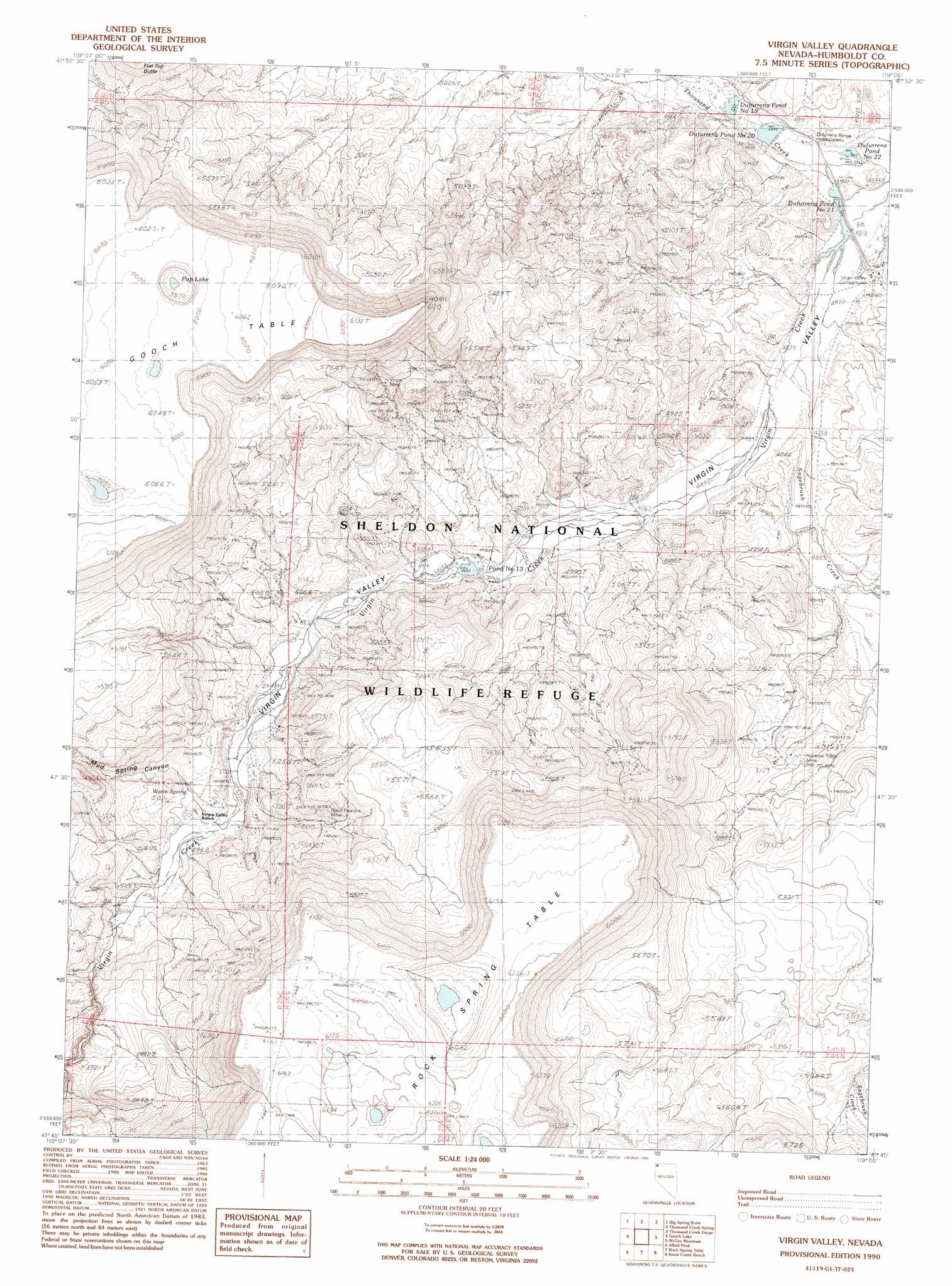
USGS Topo Quad 41119g1 - 1:24,000 scale
| Topo Map Name: | Virgin Valley |
| USGS Topo Quad ID: | 41119g1 |
| Print Size: | ca. 21 1/4" wide x 27" high |
| Southeast Coordinates: | 41.75° N latitude / 119° W longitude |
| Map Center Coordinates: | 41.8125° N latitude / 119.0625° W longitude |
| U.S. State: | NV |
| Filename: | o41119g1.jpg |
| Download Map JPG Image: | Virgin Valley topo map 1:24,000 scale |
| Map Type: | Topographic |
| Topo Series: | 7.5´ |
| Map Scale: | 1:24,000 |
| Source of Map Images: | United States Geological Survey (USGS) |
| Alternate Map Versions: |
Virgin Valley NV 1990, updated 1990 Download PDF Buy paper map Virgin Valley NV 2011 Download PDF Buy paper map Virgin Valley NV 2015 Download PDF Buy paper map |
1:24,000 Topo Quads surrounding Virgin Valley
Sage Hen Flats |
Acty Mountain |
Hawks Mountain |
Black Rock Springs |
Oregon End Table |
Sage Hen Hills |
Big Spring Butte |
Thousand Creek Spring |
Thousand Creek Gorge |
Bog Hot Springs |
Catnip Mountain Se |
Gooch Lake |
Virgin Valley |
Mcgee Mountain |
Alder Creek Ranch |
Blowout Mountain |
Alkali Peak |
Rock Spring Table |
Knott Creek Ranch |
Knott Creek |
Badger Mountain Se |
Bear Buttes |
Summit Lake |
Idaho Canyon Spring |
New York Peak |
> Back to 41119e1 at 1:100,000 scale
> Back to 41118a1 at 1:250,000 scale
> Back to U.S. Topo Maps home
Virgin Valley topo map: Gazetteer
Virgin Valley: Dams
Dam Number 10 Dam elevation 1507m 4944′Dufurrena Pond Number 19 Dam elevation 1478m 4849′
Dufurrena Pond Number 20 Dam elevation 1482m 4862′
Virgin Valley Reservoir Dam elevation 1492m 4895′
Virgin Valley: Lakes
Pup Lake elevation 1819m 5967′Virgin Valley: Mines
Rainbow Ridge Mine elevation 1557m 5108′Royal Peacock Mine elevation 1593m 5226′
Virgin Mine elevation 1642m 5387′
Virgin Valley: Reservoirs
Dufurrena Pond Number 22 elevation 1472m 4829′Dufurrena Pond Number Nineteen elevation 1478m 4849′
Dufurrena Pond Number Twenty elevation 1476m 4842′
Dufurrena Pond Number Twenty-One elevation 1470m 4822′
Pond Number Thirteen elevation 1492m 4895′
Virgin Valley Reservoir elevation 1492m 4895′
Virgin Valley: Springs
Warm Spring elevation 1523m 4996′Virgin Valley: Streams
Big Spring Creek elevation 1483m 4865′Sagebrush Creek elevation 1476m 4842′
Virgin Valley: Valleys
Mud Spring Canyon elevation 1518m 4980′Virgin Valley elevation 1476m 4842′
Virgin Valley digital topo map on disk
Buy this Virgin Valley topo map showing relief, roads, GPS coordinates and other geographical features, as a high-resolution digital map file on DVD: