Gooch Lake Topo Map Nevada
To zoom in, hover over the map of Gooch Lake
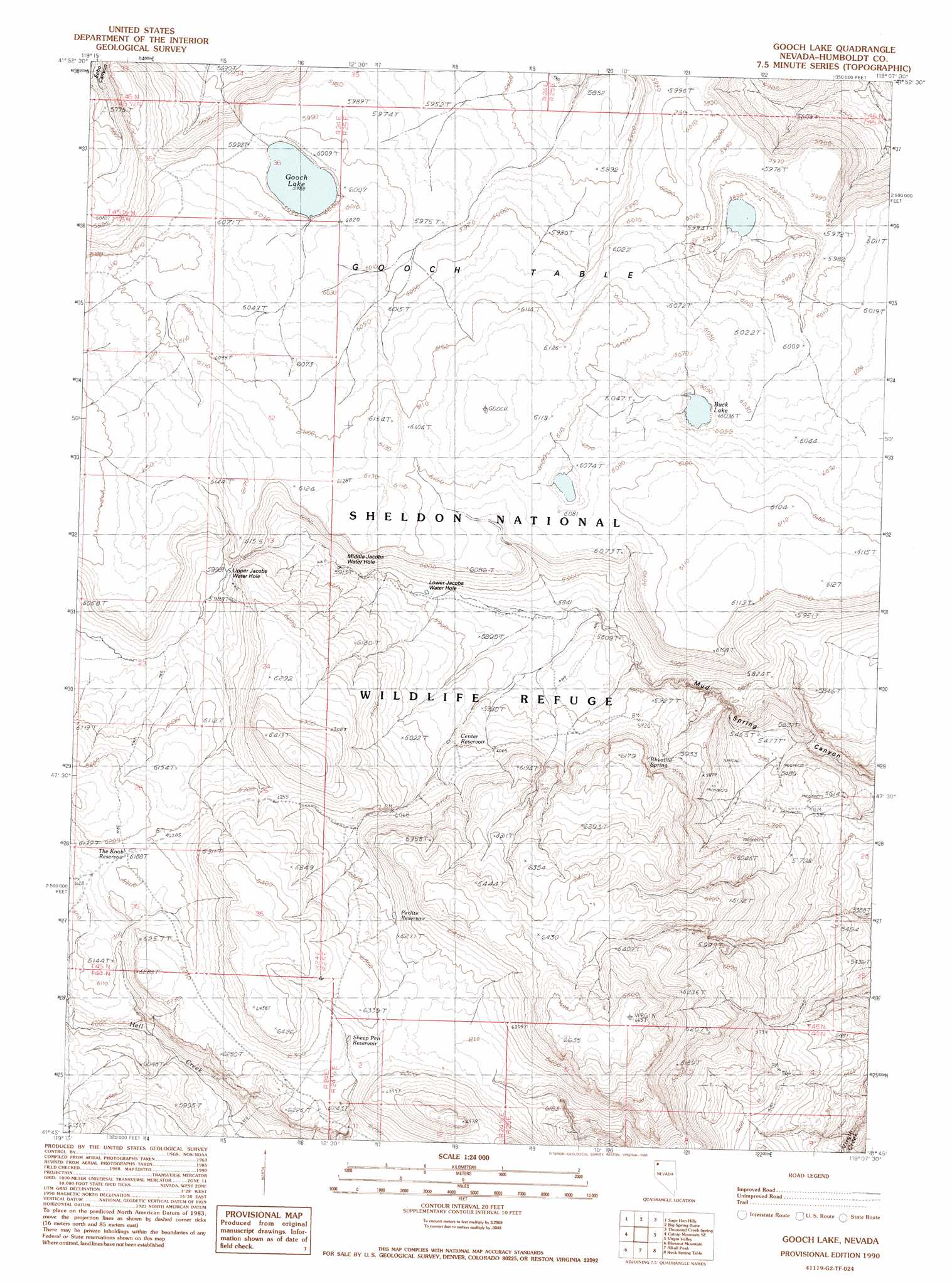
USGS Topo Quad 41119g2 - 1:24,000 scale
| Topo Map Name: | Gooch Lake |
| USGS Topo Quad ID: | 41119g2 |
| Print Size: | ca. 21 1/4" wide x 27" high |
| Southeast Coordinates: | 41.75° N latitude / 119.125° W longitude |
| Map Center Coordinates: | 41.8125° N latitude / 119.1875° W longitude |
| U.S. State: | NV |
| Filename: | o41119g2.jpg |
| Download Map JPG Image: | Gooch Lake topo map 1:24,000 scale |
| Map Type: | Topographic |
| Topo Series: | 7.5´ |
| Map Scale: | 1:24,000 |
| Source of Map Images: | United States Geological Survey (USGS) |
| Alternate Map Versions: |
Gooch Lake NV 1990, updated 1990 Download PDF Buy paper map Gooch Lake NV 2011 Download PDF Buy paper map Gooch Lake NV 2015 Download PDF Buy paper map |
1:24,000 Topo Quads surrounding Gooch Lake
Antelope Butte |
Sage Hen Flats |
Acty Mountain |
Hawks Mountain |
Black Rock Springs |
Catnip Canyon |
Sage Hen Hills |
Big Spring Butte |
Thousand Creek Spring |
Thousand Creek Gorge |
Swan Lake |
Catnip Mountain Se |
Gooch Lake |
Virgin Valley |
Mcgee Mountain |
Badger Mountain Nw |
Blowout Mountain |
Alkali Peak |
Rock Spring Table |
Knott Creek Ranch |
Nut Mountain |
Badger Mountain Se |
Bear Buttes |
Summit Lake |
Idaho Canyon Spring |
> Back to 41119e1 at 1:100,000 scale
> Back to 41118a1 at 1:250,000 scale
> Back to U.S. Topo Maps home
Gooch Lake topo map: Gazetteer
Gooch Lake: Lakes
Buck Lake elevation 1833m 6013′Gooch Lake elevation 1827m 5994′
Gooch Lake: Parks
Sheldon National Wildlife Refuge elevation 1836m 6023′Gooch Lake: Reservoirs
Center Reservoir elevation 1821m 5974′Perlite Reservoir elevation 1896m 6220′
Sheep Pen Reservoir elevation 1908m 6259′
The Knob Reservoir elevation 1889m 6197′
Gooch Lake: Springs
Jacobs Waterhole elevation 1771m 5810′Lower Jacobs Water Hole elevation 1792m 5879′
Middle Jacobs Water Hole elevation 1803m 5915′
Rhyolite Spring elevation 1831m 6007′
Upper Jacobs Water Hole elevation 1829m 6000′
Gooch Lake: Summits
Gooch Table elevation 1883m 6177′Gooch Lake digital topo map on disk
Buy this Gooch Lake topo map showing relief, roads, GPS coordinates and other geographical features, as a high-resolution digital map file on DVD: