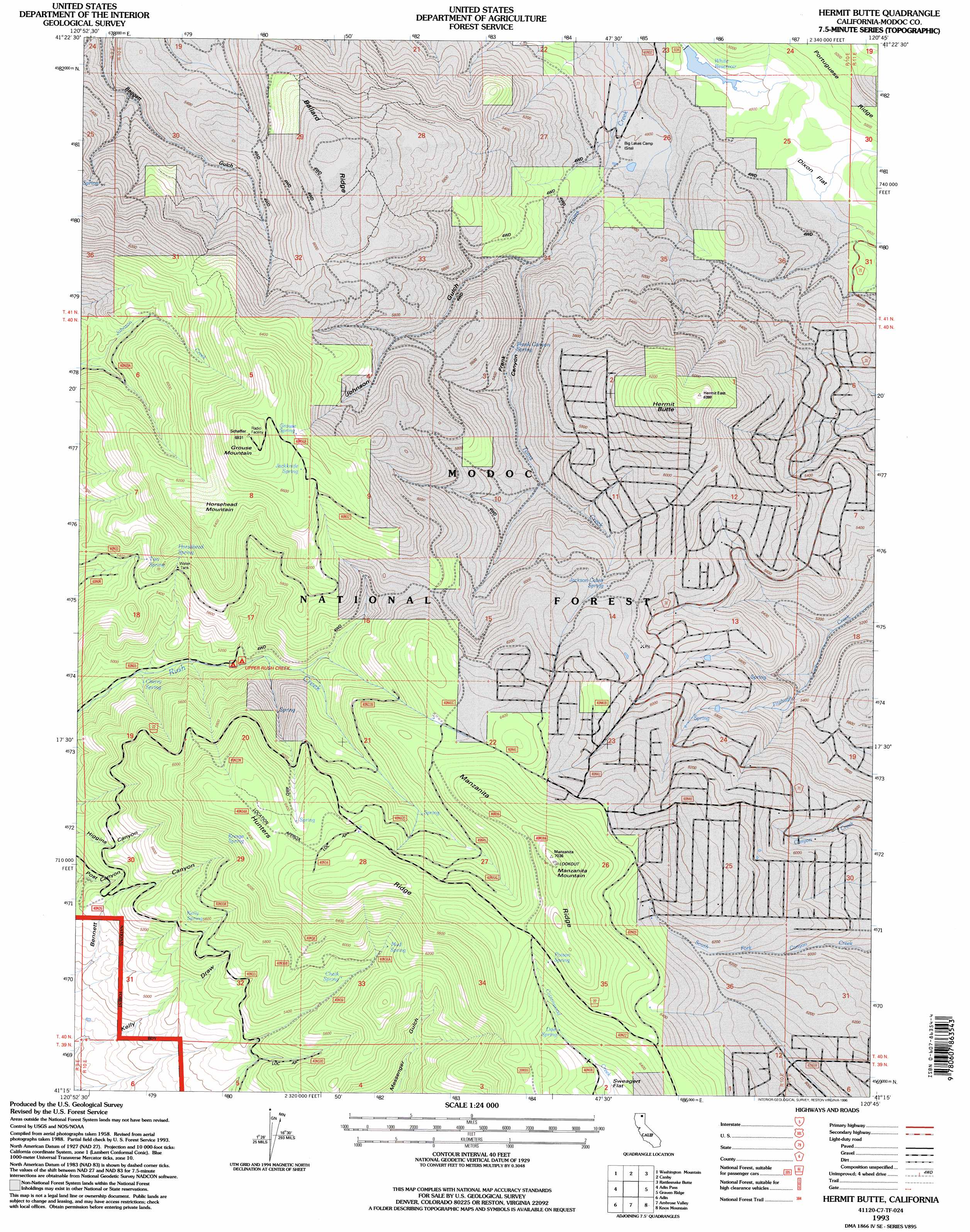
Hermit Butte Topo Map California
To zoom in, hover over the map of Hermit Butte
USGS Topo Quad 41120c7 - 1:24,000 scale
| Topo Map Name: | Hermit Butte |
| USGS Topo Quad ID: | 41120c7 |
| Print Size: | ca. 21 1/4" wide x 27" high |
| Southeast Coordinates: | 41.25° N latitude / 120.75° W longitude |
| Map Center Coordinates: | 41.3125° N latitude / 120.8125° W longitude |
| U.S. State: | CA |
| Filename: | o41120c7.jpg |
| Download Map JPG Image: | Hermit Butte topo map 1:24,000 scale |
| Map Type: | Topographic |
| Topo Series: | 7.5´ |
| Map Scale: | 1:24,000 |
| Source of Map Images: | United States Geological Survey (USGS) |
| Alternate Map Versions: |
Hermit Butte CA 1990, updated 1990 Download PDF Buy paper map Hermit Butte CA 1993, updated 1996 Download PDF Buy paper map Hermit Butte CA 2012 Download PDF Buy paper map Hermit Butte CA 2015 Download PDF Buy paper map |
| FStopo: | US Forest Service topo Hermit Butte is available: Download FStopo PDF Download FStopo TIF |
1:24,000 Topo Quads surrounding Hermit Butte
Knobcone Butte |
Ambrose |
Jacks Butte |
Big Sage Reservoir |
Mahogany Ridge |
Happy Camp Mountain |
Washington Mountain |
Canby |
Rattlesnake Butte |
Alturas |
Halls Canyon |
Adin Pass |
Hermit Butte |
Graven Ridge |
Bayley |
Big Swamp |
Adin |
Ambrose Valley |
Knox Mountain |
Likely |
Hog Valley |
Letterbox Hill |
Lane Reservoir |
Ash Valley |
Holbrook Canyon |
> Back to 41120a1 at 1:100,000 scale
> Back to 41120a1 at 1:250,000 scale
> Back to U.S. Topo Maps home
Hermit Butte topo map: Gazetteer
Hermit Butte: Dams
White 151 Dam elevation 1461m 4793′Hermit Butte: Flats
Dixon Flat elevation 1474m 4835′Hermit Butte: Reservoirs
White Reservoir elevation 1458m 4783′Hermit Butte: Ridges
Ballard Ridge elevation 1718m 5636′Hunters Ridge elevation 2077m 6814′
Manzanita Ridge elevation 2098m 6883′
Portuguese Ridge elevation 1551m 5088′
Hermit Butte: Springs
Chalk Spring elevation 1710m 5610′Cherry Spring elevation 1518m 4980′
Doe Spring elevation 1917m 6289′
Frank Canyon Spring elevation 1610m 5282′
Grouse Spring elevation 2004m 6574′
Horsehead Spring elevation 1760m 5774′
Jackknife Spring elevation 1995m 6545′
Jackson Cabin Spring elevation 1793m 5882′
Kelly Spring elevation 1675m 5495′
Kresge Spring elevation 1951m 6400′
Mud Spring elevation 1795m 5889′
Poison Spring elevation 2038m 6686′
Two Spring elevation 1695m 5561′
Hermit Butte: Summits
Grouse Mountain elevation 2111m 6925′Hermit Butte elevation 1979m 6492′
Horsehead Mountain elevation 1988m 6522′
Manzanita Mountain elevation 2137m 7011′
Hermit Butte: Valleys
Johnson Gulch elevation 1563m 5127′Hermit Butte digital topo map on disk
Buy this Hermit Butte topo map showing relief, roads, GPS coordinates and other geographical features, as a high-resolution digital map file on DVD: