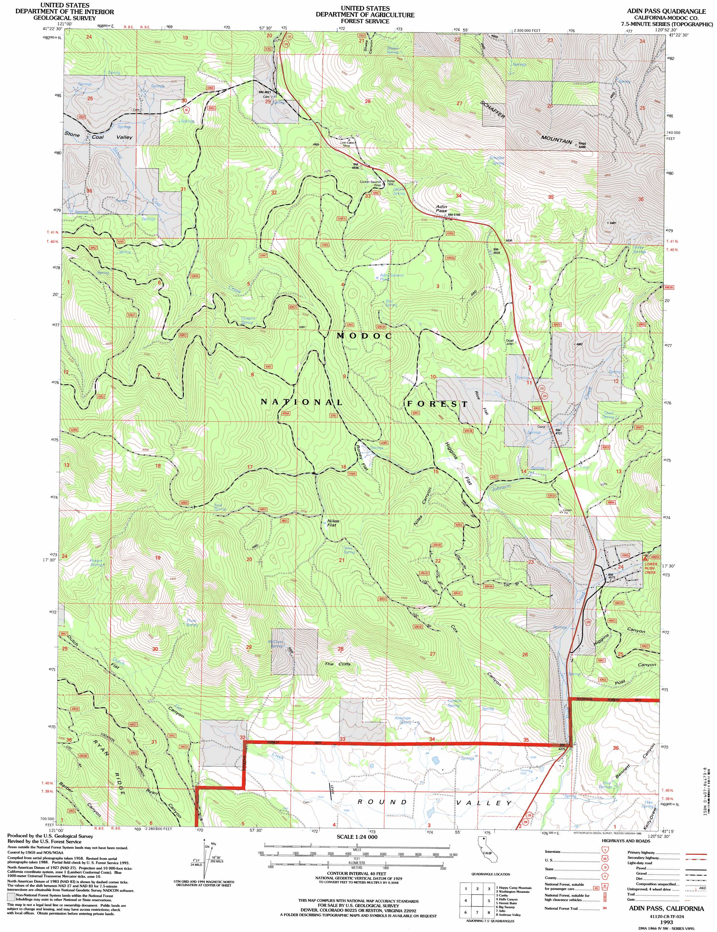
Adin Pass Topo Map California
To zoom in, hover over the map of Adin Pass
USGS Topo Quad 41120c8 - 1:24,000 scale
| Topo Map Name: | Adin Pass |
| USGS Topo Quad ID: | 41120c8 |
| Print Size: | ca. 21 1/4" wide x 27" high |
| Southeast Coordinates: | 41.25° N latitude / 120.875° W longitude |
| Map Center Coordinates: | 41.3125° N latitude / 120.9375° W longitude |
| U.S. State: | CA |
| Filename: | o41120c8.jpg |
| Download Map JPG Image: | Adin Pass topo map 1:24,000 scale |
| Map Type: | Topographic |
| Topo Series: | 7.5´ |
| Map Scale: | 1:24,000 |
| Source of Map Images: | United States Geological Survey (USGS) |
| Alternate Map Versions: |
Adin Pass CA 1990, updated 1990 Download PDF Buy paper map Adin Pass CA 1993, updated 1996 Download PDF Buy paper map Adin Pass CA 2012 Download PDF Buy paper map Adin Pass CA 2015 Download PDF Buy paper map |
| FStopo: | US Forest Service topo Adin Pass is available: Download FStopo PDF Download FStopo TIF |
1:24,000 Topo Quads surrounding Adin Pass
Spaulding Butte |
Knobcone Butte |
Ambrose |
Jacks Butte |
Big Sage Reservoir |
Crank Mountain |
Happy Camp Mountain |
Washington Mountain |
Canby |
Rattlesnake Butte |
Donica Mountain |
Halls Canyon |
Adin Pass |
Hermit Butte |
Graven Ridge |
Lookout |
Big Swamp |
Adin |
Ambrose Valley |
Knox Mountain |
Bieber |
Hog Valley |
Letterbox Hill |
Lane Reservoir |
Ash Valley |
> Back to 41120a1 at 1:100,000 scale
> Back to 41120a1 at 1:250,000 scale
> Back to U.S. Topo Maps home
Adin Pass topo map: Gazetteer
Adin Pass: Cliffs
The Cliffs elevation 1452m 4763′Adin Pass: Flats
Higgins Flat elevation 1404m 4606′Niles Flat elevation 1556m 5104′
Rice Flat elevation 1437m 4714′
Roney Flat elevation 1489m 4885′
Adin Pass: Gaps
Adin Pass elevation 1583m 5193′Adin Pass: Lakes
Adin Summit Pond elevation 1615m 5298′Adin Pass: Mines
Lost Cabin Mine elevation 1514m 4967′Adin Pass: Ridges
Ryan Ridge elevation 1698m 5570′Adin Pass: Springs
Antelope Spring elevation 1338m 4389′Conklin Spring elevation 1382m 4534′
Fork Spring elevation 1690m 5544′
Harper Spring elevation 1462m 4796′
Harris Spring elevation 1520m 4986′
Haw Spring elevation 1383m 4537′
Horse Springs elevation 1596m 5236′
Hoskins Spring elevation 1501m 4924′
McClure Spring elevation 1474m 4835′
Niles Spring elevation 1612m 5288′
Plum Spring elevation 1483m 4865′
Quail Spring elevation 1488m 4881′
Rice Spring elevation 1585m 5200′
Rice Springs elevation 1383m 4537′
Schaffer Spring elevation 1699m 5574′
Shake Spring elevation 1613m 5291′
Adin Pass: Streams
Johnson Creek elevation 1373m 4504′Adin Pass: Summits
Schaffer Mountain elevation 1988m 6522′Adin Pass: Valleys
Bennett Canyon elevation 1388m 4553′Cox Canyon elevation 1344m 4409′
Dutch Flat Canyon elevation 1336m 4383′
Higgins Canyon elevation 1375m 4511′
Niles Canyon elevation 1413m 4635′
Post Canyon elevation 1371m 4498′
Adin Pass digital topo map on disk
Buy this Adin Pass topo map showing relief, roads, GPS coordinates and other geographical features, as a high-resolution digital map file on DVD: