Washington Mountain Topo Map California
To zoom in, hover over the map of Washington Mountain
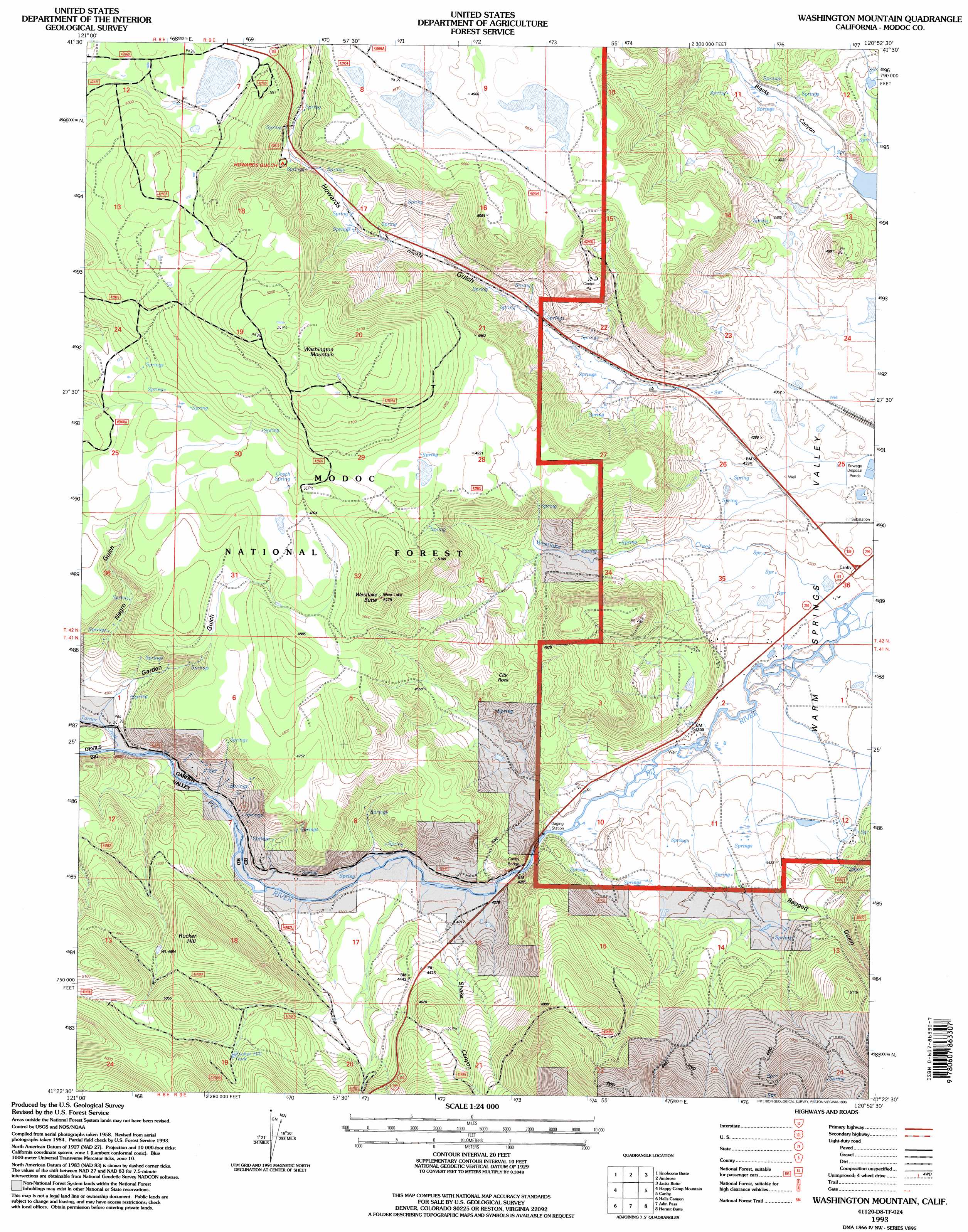
USGS Topo Quad 41120d8 - 1:24,000 scale
| Topo Map Name: | Washington Mountain |
| USGS Topo Quad ID: | 41120d8 |
| Print Size: | ca. 21 1/4" wide x 27" high |
| Southeast Coordinates: | 41.375° N latitude / 120.875° W longitude |
| Map Center Coordinates: | 41.4375° N latitude / 120.9375° W longitude |
| U.S. State: | CA |
| Filename: | o41120d8.jpg |
| Download Map JPG Image: | Washington Mountain topo map 1:24,000 scale |
| Map Type: | Topographic |
| Topo Series: | 7.5´ |
| Map Scale: | 1:24,000 |
| Source of Map Images: | United States Geological Survey (USGS) |
| Alternate Map Versions: |
Washington Mountain CA 1990, updated 1990 Download PDF Buy paper map Washington Mountain CA 1993, updated 1996 Download PDF Buy paper map Washington Mountain CA 2012 Download PDF Buy paper map Washington Mountain CA 2015 Download PDF Buy paper map |
| FStopo: | US Forest Service topo Washington Mountain is available: Download FStopo PDF Download FStopo TIF |
1:24,000 Topo Quads surrounding Washington Mountain
Rimrock Lake |
Lone Pine Butte |
Boles Meadows West |
Boles Meadows East |
Whittemore Ridge |
Spaulding Butte |
Knobcone Butte |
Ambrose |
Jacks Butte |
Big Sage Reservoir |
Crank Mountain |
Happy Camp Mountain |
Washington Mountain |
Canby |
Rattlesnake Butte |
Donica Mountain |
Halls Canyon |
Adin Pass |
Hermit Butte |
Graven Ridge |
Lookout |
Big Swamp |
Adin |
Ambrose Valley |
Knox Mountain |
> Back to 41120a1 at 1:100,000 scale
> Back to 41120a1 at 1:250,000 scale
> Back to U.S. Topo Maps home
Washington Mountain topo map: Gazetteer
Washington Mountain: Bridges
Canby Bridge elevation 1303m 4274′Washington Mountain: Pillars
City Rock elevation 1434m 4704′Washington Mountain: Reservoirs
Rucker Hill Tank elevation 1427m 4681′Washington Mountain: Springs
Gosch Spring elevation 1501m 4924′Washington Mountain: Streams
Turner Creek elevation 1297m 4255′Westlake Creek elevation 1309m 4294′
Washington Mountain: Summits
Rucker Hill elevation 1543m 5062′Washington Mountain elevation 1620m 5314′
Westlake Butte elevation 1585m 5200′
Washington Mountain: Valleys
Baggett Gulch elevation 1385m 4543′Garden Gulch elevation 1308m 4291′
Howards Gulch elevation 1332m 4370′
Negro Gulch elevation 1321m 4333′
Shake Canyon elevation 1302m 4271′
Washington Mountain digital topo map on disk
Buy this Washington Mountain topo map showing relief, roads, GPS coordinates and other geographical features, as a high-resolution digital map file on DVD: