Bieber Topo Map California
To zoom in, hover over the map of Bieber
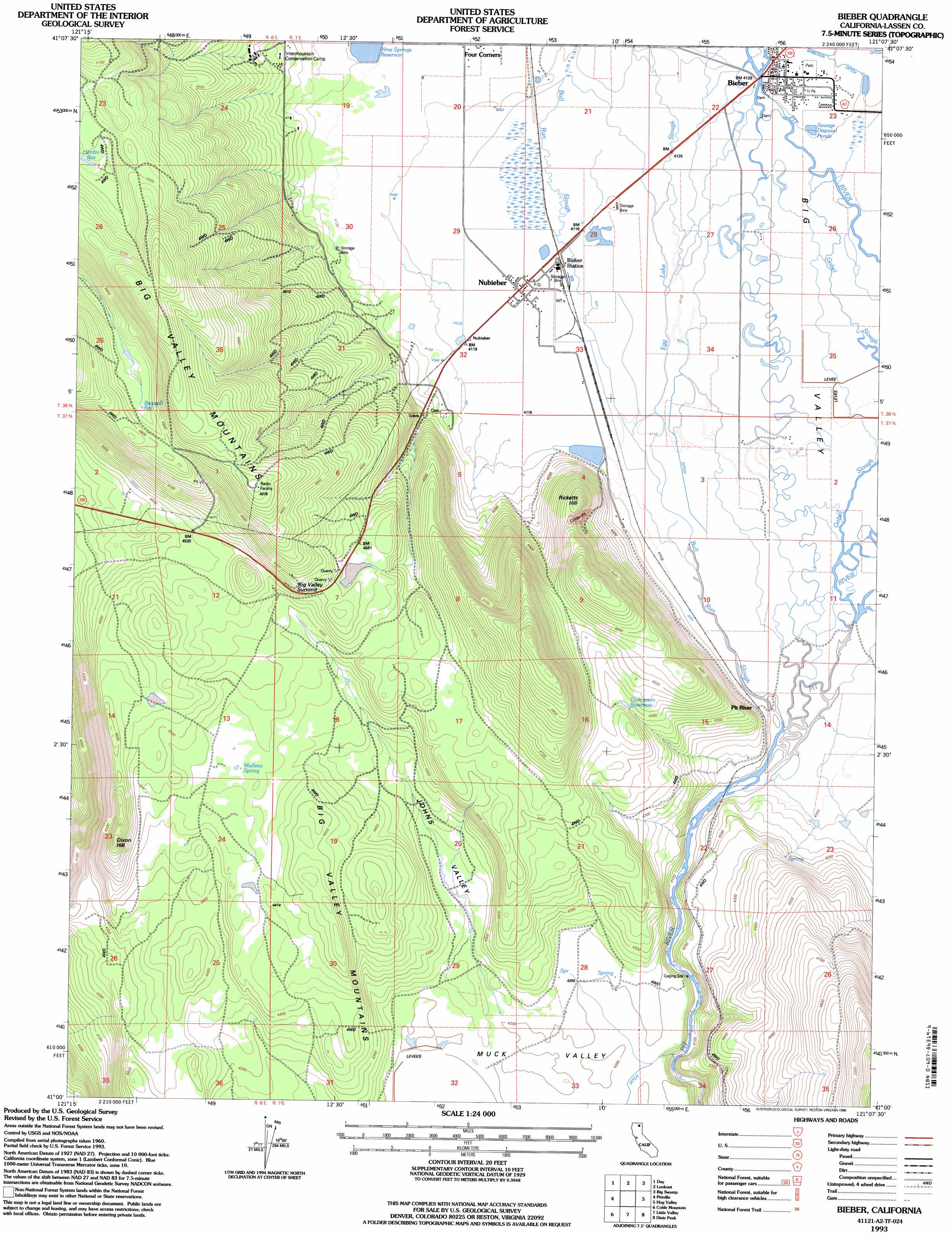
USGS Topo Quad 41121a2 - 1:24,000 scale
| Topo Map Name: | Bieber |
| USGS Topo Quad ID: | 41121a2 |
| Print Size: | ca. 21 1/4" wide x 27" high |
| Southeast Coordinates: | 41° N latitude / 121.125° W longitude |
| Map Center Coordinates: | 41.0625° N latitude / 121.1875° W longitude |
| U.S. State: | CA |
| Filename: | o41121a2.jpg |
| Download Map JPG Image: | Bieber topo map 1:24,000 scale |
| Map Type: | Topographic |
| Topo Series: | 7.5´ |
| Map Scale: | 1:24,000 |
| Source of Map Images: | United States Geological Survey (USGS) |
| Alternate Map Versions: |
Bieber CA 1990, updated 1990 Download PDF Buy paper map Bieber CA 1993, updated 1996 Download PDF Buy paper map Bieber CA 2012 Download PDF Buy paper map Bieber CA 2015 Download PDF Buy paper map |
| FStopo: | US Forest Service topo Bieber is available: Download FStopo PDF Download FStopo TIF |
1:24,000 Topo Quads surrounding Bieber
Whitehorse |
Egg Lake |
Donica Mountain |
Halls Canyon |
Adin Pass |
Timbered Crater |
Day |
Lookout |
Big Swamp |
Adin |
Fall River Mills |
Pittville |
Bieber |
Hog Valley |
Letterbox Hill |
Hogback Ridge |
Coble Mountain |
Little Valley |
Dixie Peak |
Silva Flat Reservoir |
Murken Bench |
Jellico |
Corders Reservoir |
Straylor Lake |
Bullard Lake |
> Back to 41121a1 at 1:100,000 scale
> Back to 41120a1 at 1:250,000 scale
> Back to U.S. Topo Maps home
Bieber topo map: Gazetteer
Bieber: Dams
Nine Springs 1245 Dam elevation 1260m 4133′Bieber: Gaps
Big Valley Summit elevation 1406m 4612′Bieber: Parks
Clara Bieber Memorial Park elevation 1257m 4124′Bieber: Populated Places
Bieber elevation 1257m 4124′Nubieber elevation 1256m 4120′
Bieber: Post Offices
Bieber Post Office elevation 1257m 4124′Nubieber Post Office elevation 1256m 4120′
Bieber: Reservoirs
Bagwell Reservoir elevation 1474m 4835′Hardin Reservoir elevation 1487m 4878′
Nine Springs Reservoir elevation 1262m 4140′
Thompson Reservoir elevation 1348m 4422′
Bieber: Springs
Mullens Spring elevation 1357m 4452′Bieber: Streams
Bull Run Slough elevation 1251m 4104′Egg Lake Slough elevation 1251m 4104′
Gobel Slough elevation 1252m 4107′
Bieber: Summits
Dixon Hill elevation 1426m 4678′Ricketts Hill elevation 1385m 4543′
Bieber: Valleys
Big Valley elevation 1250m 4101′Johns Valley elevation 1291m 4235′
Muck Valley elevation 1278m 4192′
Bieber digital topo map on disk
Buy this Bieber topo map showing relief, roads, GPS coordinates and other geographical features, as a high-resolution digital map file on DVD: