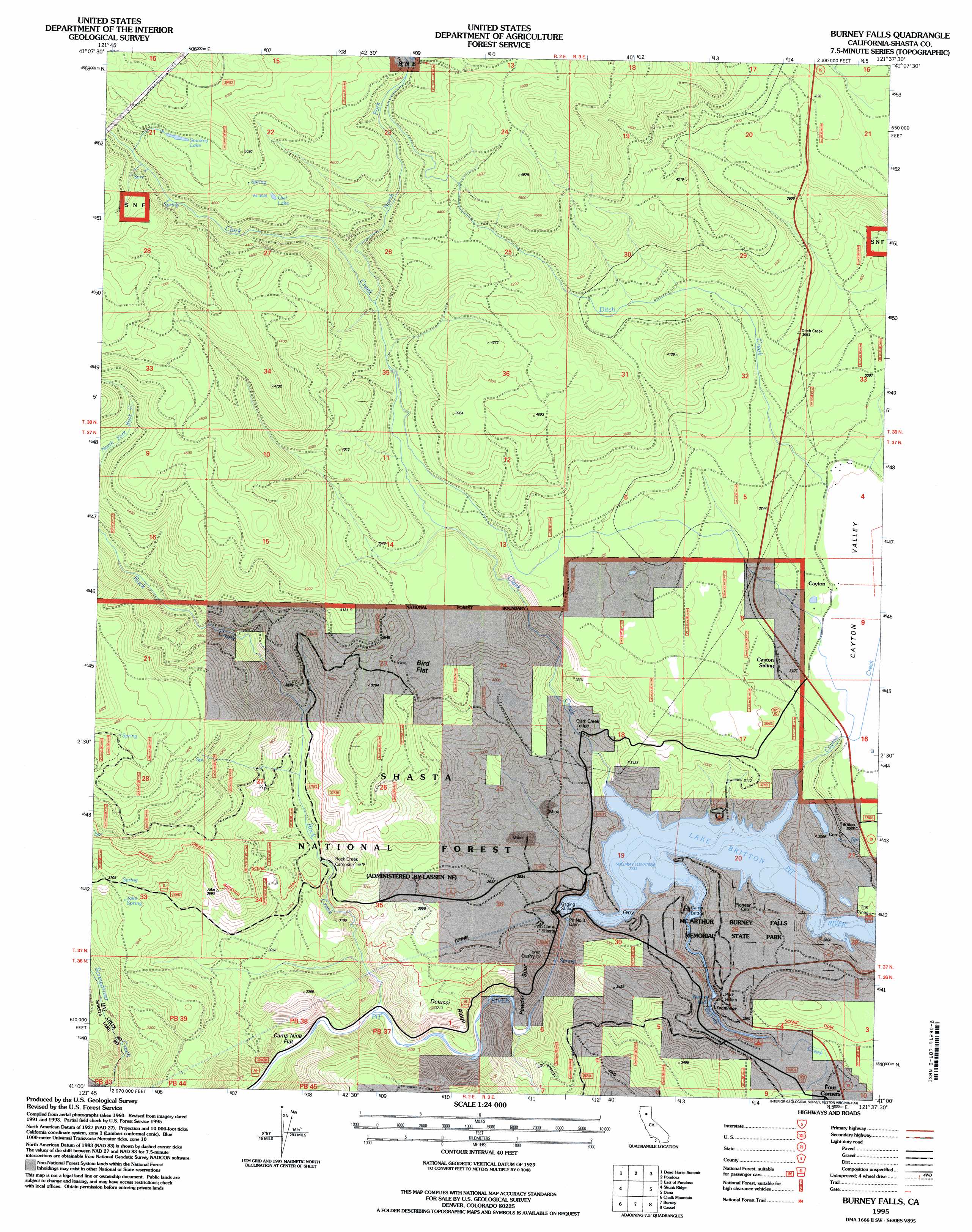
Burney Falls Topo Map California
To zoom in, hover over the map of Burney Falls
USGS Topo Quad 41121a6 - 1:24,000 scale
| Topo Map Name: | Burney Falls |
| USGS Topo Quad ID: | 41121a6 |
| Print Size: | ca. 21 1/4" wide x 27" high |
| Southeast Coordinates: | 41° N latitude / 121.625° W longitude |
| Map Center Coordinates: | 41.0625° N latitude / 121.6875° W longitude |
| U.S. State: | CA |
| Filename: | o41121a6.jpg |
| Download Map JPG Image: | Burney Falls topo map 1:24,000 scale |
| Map Type: | Topographic |
| Topo Series: | 7.5´ |
| Map Scale: | 1:24,000 |
| Source of Map Images: | United States Geological Survey (USGS) |
| Alternate Map Versions: |
Burney Falls CA 1990, updated 1990 Download PDF Buy paper map Burney Falls CA 1995, updated 1998 Download PDF Buy paper map Burney Falls CA 1995, updated 1998 Download PDF Buy paper map Burney Falls CA 2012 Download PDF Buy paper map Burney Falls CA 2015 Download PDF Buy paper map |
| FStopo: | US Forest Service topo Burney Falls is available: Download FStopo PDF Download FStopo TIF |
1:24,000 Topo Quads surrounding Burney Falls
Kinyon |
Bartle |
Hambone |
Indian Spring Mountain |
Whitehorse |
Grizzly Peak |
Dead Horse Summit |
Pondosa |
East Of Pondosa |
Timbered Crater |
Big Bend |
Skunk Ridge |
Burney Falls |
Dana |
Fall River Mills |
Roaring Creek |
Chalk Mountain |
Burney |
Cassel |
Hogback Ridge |
Montgomery Creek |
Hatchet Mountain Pass |
Burney Mountain West |
Burney Mountain East |
Murken Bench |
> Back to 41121a1 at 1:100,000 scale
> Back to 41120a1 at 1:250,000 scale
> Back to U.S. Topo Maps home
Burney Falls topo map: Gazetteer
Burney Falls: Dams
Pit Number 3 97-098 Dam elevation 833m 2732′Pit Number Three Dam elevation 825m 2706′
Burney Falls: Falls
Burney Falls elevation 893m 2929′Burney Falls: Flats
Bird Flat elevation 1097m 3599′Camp Nine Flat elevation 775m 2542′
Burney Falls: Lakes
Owl Lake elevation 1388m 4553′Smokey Lake elevation 1474m 4835′
Burney Falls: Parks
McArthur-Burney Falls Memorial State Park elevation 886m 2906′Burney Falls: Populated Places
Cayton elevation 939m 3080′Burney Falls: Reservoirs
Lake Britton elevation 835m 2739′Burney Falls: Ridges
Delucci Ridge elevation 967m 3172′Powder Spur elevation 905m 2969′
Burney Falls: Springs
Jake Spring elevation 1112m 3648′Burney Falls: Streams
Burney Creek elevation 835m 2739′Cayton Creek elevation 835m 2739′
Clark Creek elevation 842m 2762′
Ditch Creek elevation 942m 3090′
North Fork Clark Creek elevation 1132m 3713′
Rock Creek elevation 775m 2542′
Burney Falls: Trails
Creek Trail elevation 838m 2749′Falls Trail elevation 856m 2808′
Headwaters Trail elevation 896m 2939′
Burney Falls: Valleys
Cayton Valley elevation 928m 3044′Burney Falls digital topo map on disk
Buy this Burney Falls topo map showing relief, roads, GPS coordinates and other geographical features, as a high-resolution digital map file on DVD: