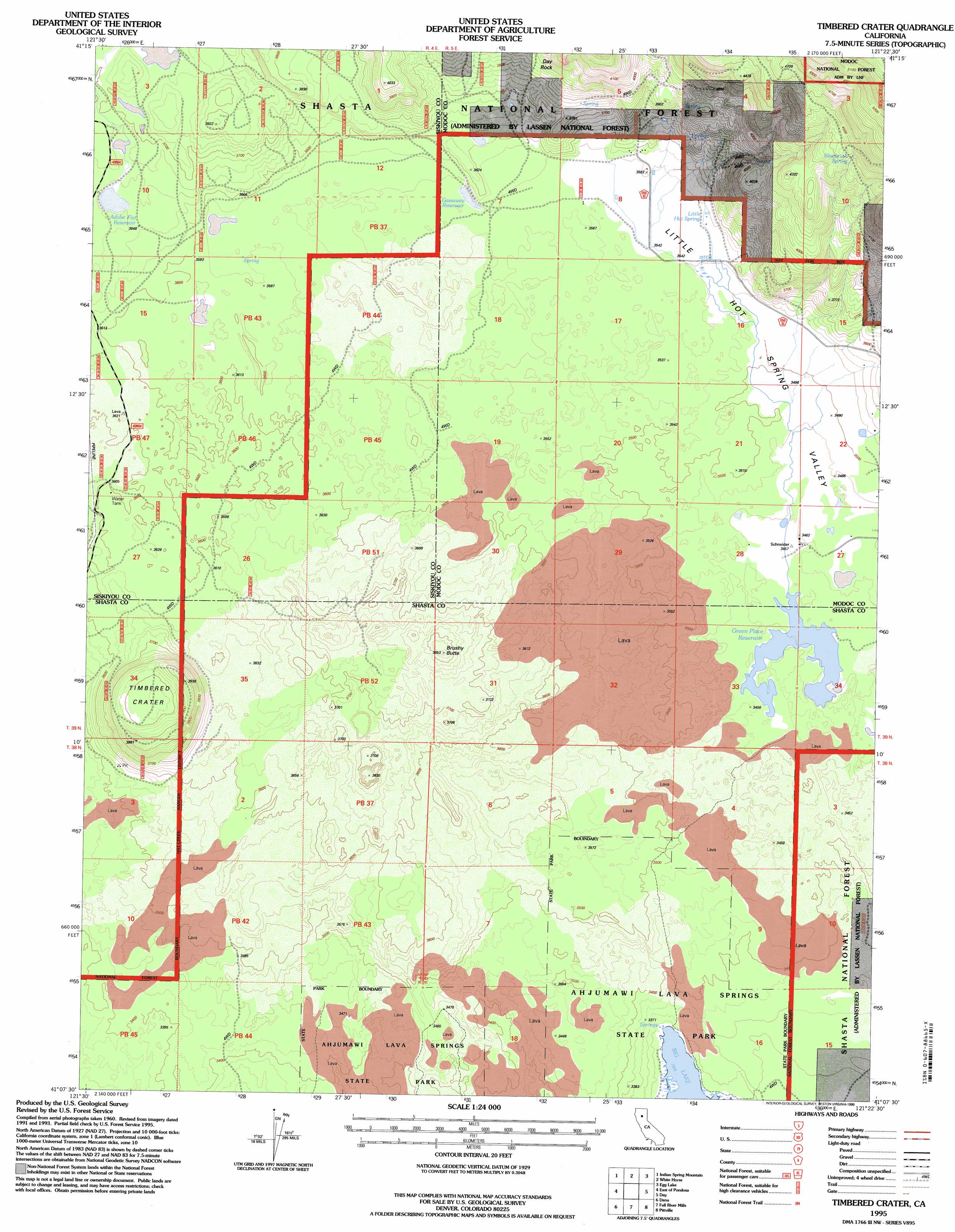
Timbered Crater Topo Map California
To zoom in, hover over the map of Timbered Crater
USGS Topo Quad 41121b4 - 1:24,000 scale
| Topo Map Name: | Timbered Crater |
| USGS Topo Quad ID: | 41121b4 |
| Print Size: | ca. 21 1/4" wide x 27" high |
| Southeast Coordinates: | 41.125° N latitude / 121.375° W longitude |
| Map Center Coordinates: | 41.1875° N latitude / 121.4375° W longitude |
| U.S. State: | CA |
| Filename: | o41121b4.jpg |
| Download Map JPG Image: | Timbered Crater topo map 1:24,000 scale |
| Map Type: | Topographic |
| Topo Series: | 7.5´ |
| Map Scale: | 1:24,000 |
| Source of Map Images: | United States Geological Survey (USGS) |
| Alternate Map Versions: |
Timbered Crater CA 1990, updated 1990 Download PDF Buy paper map Timbered Crater CA 1995, updated 1998 Download PDF Buy paper map Timbered Crater CA 2012 Download PDF Buy paper map Timbered Crater CA 2015 Download PDF Buy paper map |
| FStopo: | US Forest Service topo Timbered Crater is available: Download FStopo PDF Download FStopo TIF |
1:24,000 Topo Quads surrounding Timbered Crater
Snag Hill |
Porcupine Butte |
Border Mountain |
Hollenbeck |
Crank Mountain |
Hambone |
Indian Spring Mountain |
Whitehorse |
Egg Lake |
Donica Mountain |
Pondosa |
East Of Pondosa |
Timbered Crater |
Day |
Lookout |
Burney Falls |
Dana |
Fall River Mills |
Pittville |
Bieber |
Burney |
Cassel |
Hogback Ridge |
Coble Mountain |
Little Valley |
> Back to 41121a1 at 1:100,000 scale
> Back to 41120a1 at 1:250,000 scale
> Back to U.S. Topo Maps home
Timbered Crater topo map: Gazetteer
Timbered Crater: Craters
Timbered Crater elevation 1154m 3786′Timbered Crater: Flats
Adobe Flat elevation 1117m 3664′Timbered Crater: Parks
Ahjumawi Lava Springs State Park elevation 1051m 3448′Timbered Crater: Pillars
Day Rock elevation 1223m 4012′Timbered Crater: Reservoirs
Adobe Flat Reservoir elevation 1121m 3677′Gassaway Reservoir elevation 1081m 3546′
Green Place Reservoir elevation 1049m 3441′
Timbered Crater: Springs
Bluebrush Spring elevation 1339m 4393′Little Hot Spring elevation 1084m 3556′
Timbered Crater: Summits
Brushy Butte elevation 1157m 3795′Timbered Crater: Valleys
Little Hot Spring Valley elevation 1054m 3458′Timbered Crater digital topo map on disk
Buy this Timbered Crater topo map showing relief, roads, GPS coordinates and other geographical features, as a high-resolution digital map file on DVD: