Pondosa Topo Map California
To zoom in, hover over the map of Pondosa
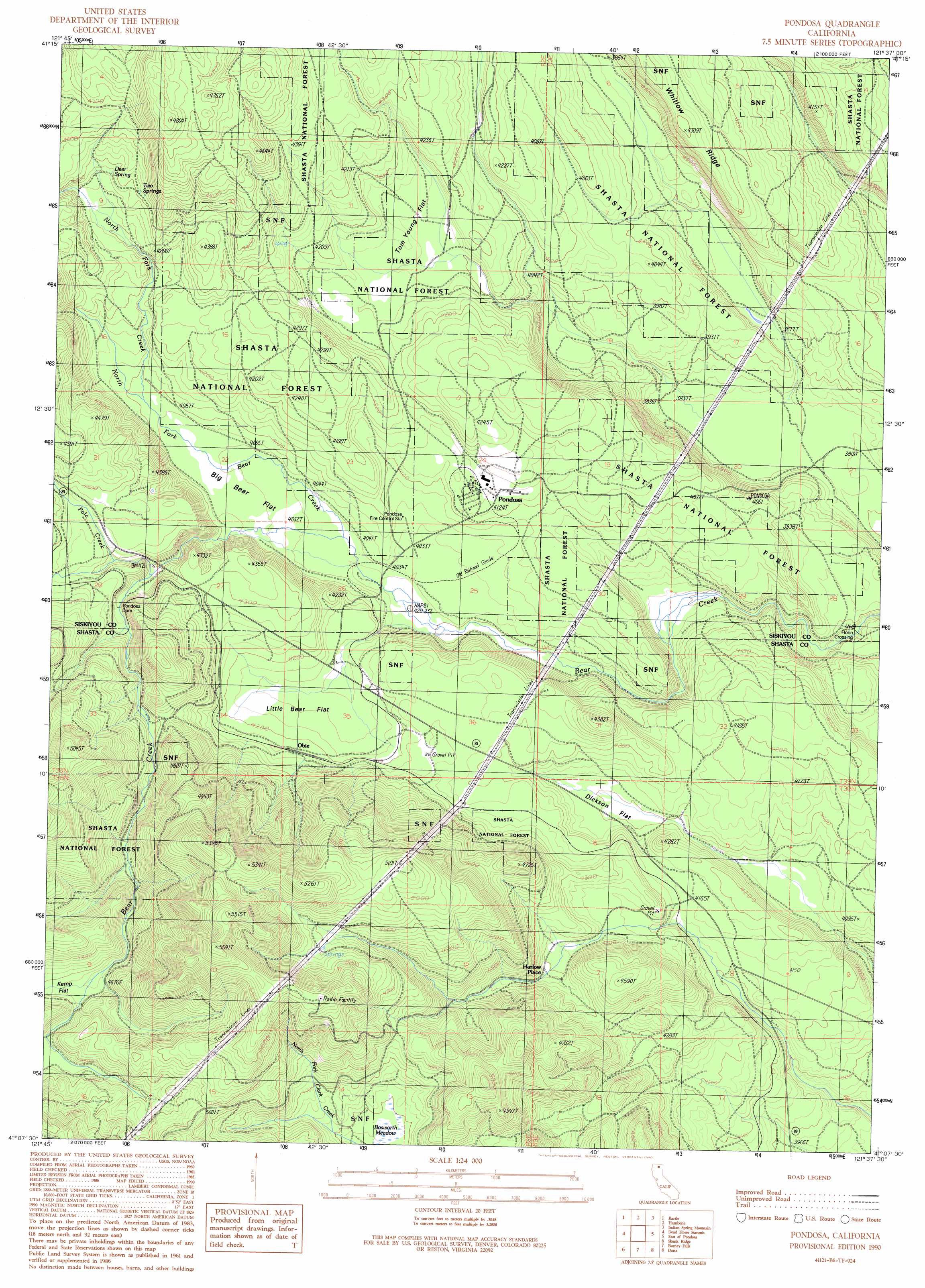
USGS Topo Quad 41121b6 - 1:24,000 scale
| Topo Map Name: | Pondosa |
| USGS Topo Quad ID: | 41121b6 |
| Print Size: | ca. 21 1/4" wide x 27" high |
| Southeast Coordinates: | 41.125° N latitude / 121.625° W longitude |
| Map Center Coordinates: | 41.1875° N latitude / 121.6875° W longitude |
| U.S. State: | CA |
| Filename: | o41121b6.jpg |
| Download Map JPG Image: | Pondosa topo map 1:24,000 scale |
| Map Type: | Topographic |
| Topo Series: | 7.5´ |
| Map Scale: | 1:24,000 |
| Source of Map Images: | United States Geological Survey (USGS) |
| Alternate Map Versions: |
Pondosa CA 1990, updated 1990 Download PDF Buy paper map Pondosa CA 1998, updated 2003 Download PDF Buy paper map Pondosa CA 2012 Download PDF Buy paper map Pondosa CA 2015 Download PDF Buy paper map |
| FStopo: | US Forest Service topo Pondosa is available: Download FStopo PDF Download FStopo TIF |
1:24,000 Topo Quads surrounding Pondosa
Rainbow Mountain |
Horse Peak |
Snag Hill |
Porcupine Butte |
Border Mountain |
Kinyon |
Bartle |
Hambone |
Indian Spring Mountain |
Whitehorse |
Grizzly Peak |
Dead Horse Summit |
Pondosa |
East Of Pondosa |
Timbered Crater |
Big Bend |
Skunk Ridge |
Burney Falls |
Dana |
Fall River Mills |
Roaring Creek |
Chalk Mountain |
Burney |
Cassel |
Hogback Ridge |
> Back to 41121a1 at 1:100,000 scale
> Back to 41120a1 at 1:250,000 scale
> Back to U.S. Topo Maps home
Pondosa topo map: Gazetteer
Pondosa: Crossings
Florin Crossing elevation 1176m 3858′Pondosa: Dams
Pondosa Dam elevation 1294m 4245′Pondosa: Flats
Big Bear Flat elevation 1238m 4061′Bosworth Meadow elevation 1401m 4596′
Dickson Flat elevation 1252m 4107′
Kemp Flat elevation 1424m 4671′
Little Bear Flat elevation 1267m 4156′
Tom Young Flat elevation 1264m 4146′
Pondosa: Populated Places
Harlow Place elevation 1341m 4399′Obie elevation 1289m 4229′
Pondosa elevation 1262m 4140′
Pondosa: Springs
Deer Spring elevation 1300m 4265′Two Springs elevation 1314m 4311′
Pondosa: Streams
North Fork Bear Creek elevation 1227m 4025′North Fork Creek elevation 1247m 4091′
Pole Creek elevation 1279m 4196′
Pondosa digital topo map on disk
Buy this Pondosa topo map showing relief, roads, GPS coordinates and other geographical features, as a high-resolution digital map file on DVD: