Medicine Lake Topo Map California
To zoom in, hover over the map of Medicine Lake
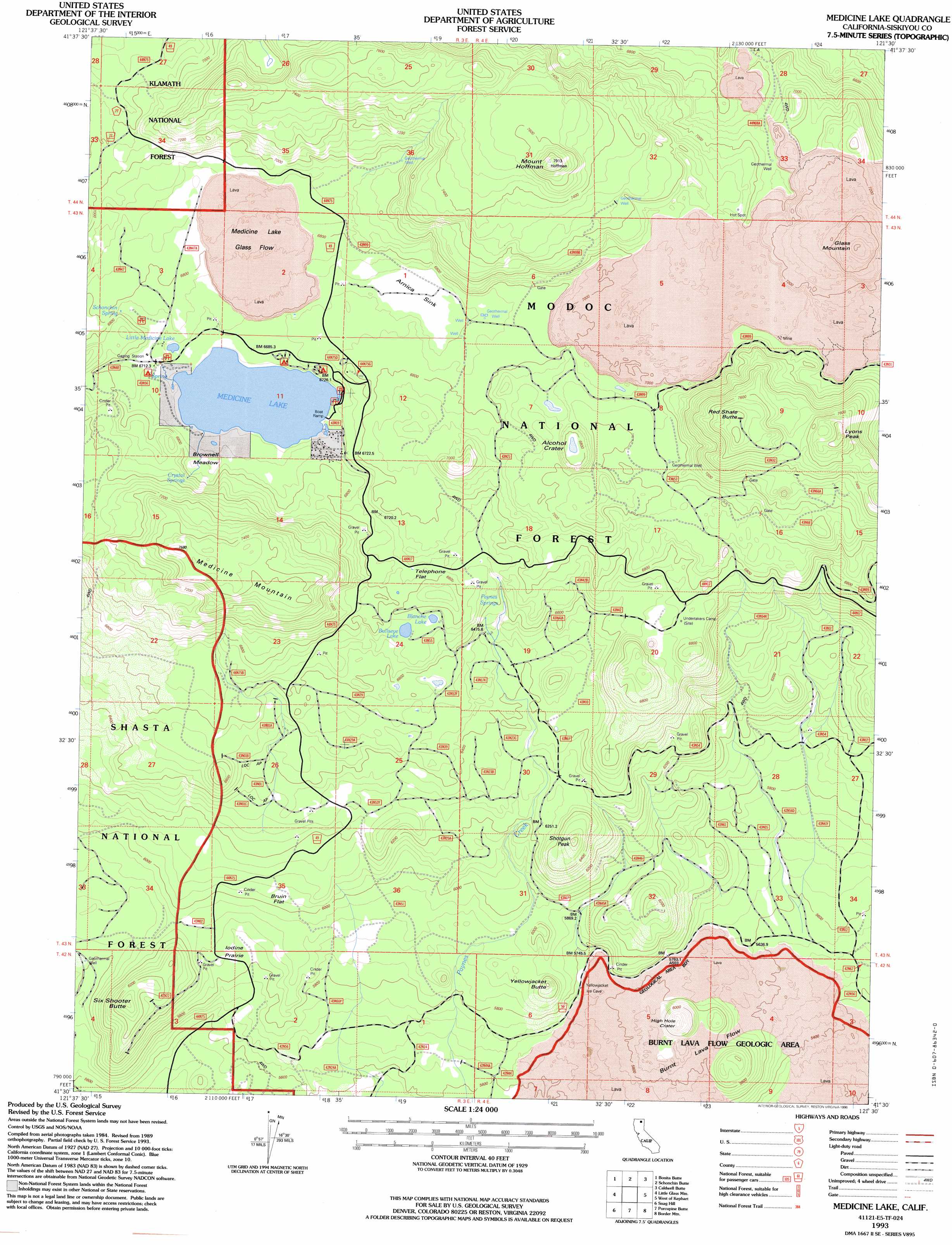
USGS Topo Quad 41121e5 - 1:24,000 scale
| Topo Map Name: | Medicine Lake |
| USGS Topo Quad ID: | 41121e5 |
| Print Size: | ca. 21 1/4" wide x 27" high |
| Southeast Coordinates: | 41.5° N latitude / 121.5° W longitude |
| Map Center Coordinates: | 41.5625° N latitude / 121.5625° W longitude |
| U.S. State: | CA |
| Filename: | o41121e5.jpg |
| Download Map JPG Image: | Medicine Lake topo map 1:24,000 scale |
| Map Type: | Topographic |
| Topo Series: | 7.5´ |
| Map Scale: | 1:24,000 |
| Source of Map Images: | United States Geological Survey (USGS) |
| Alternate Map Versions: |
Medicine Lake CA 1988, updated 1988 Download PDF Buy paper map Medicine Lake CA 1993, updated 1996 Download PDF Buy paper map Medicine Lake CA 1993, updated 1996 Download PDF Buy paper map Medicine Lake CA 2001, updated 2004 Download PDF Buy paper map Medicine Lake CA 2012 Download PDF Buy paper map Medicine Lake CA 2015 Download PDF Buy paper map |
| FStopo: | US Forest Service topo Medicine Lake is available: Download FStopo PDF Download FStopo TIF |
1:24,000 Topo Quads surrounding Medicine Lake
Red Rock Lakes |
Mount Dome |
Captain Jacks Stronghold |
The Panhandle |
Copic |
Sharp Mountain |
Bonita Butte |
Schonchin Butte |
Caldwell Butte |
Perez |
Garner Mountain |
Little Glass Mountain |
Medicine Lake |
West Of Kephart |
Kephart |
Horse Peak |
Snag Hill |
Porcupine Butte |
Border Mountain |
Hollenbeck |
Bartle |
Hambone |
Indian Spring Mountain |
Whitehorse |
Egg Lake |
> Back to 41121e1 at 1:100,000 scale
> Back to 41120a1 at 1:250,000 scale
> Back to U.S. Topo Maps home
Medicine Lake topo map: Gazetteer
Medicine Lake: Areas
Burnt Lava Flow Geological Area elevation 1732m 5682′Iodine Prairie elevation 1777m 5830′
Medicine Lake: Basins
Arnica Sink elevation 2042m 6699′Medicine Lake: Craters
Alcohol Crater elevation 2067m 6781′High Hole Crater elevation 1838m 6030′
Medicine Lake: Flats
Brownell Meadow elevation 2045m 6709′Bruin Flat elevation 1849m 6066′
Telephone Flat elevation 2056m 6745′
Medicine Lake: Lakes
Blanche Lake elevation 2056m 6745′Bullseye Lake elevation 2055m 6742′
Little Medicine Lake elevation 2049m 6722′
Medicine Lake elevation 2031m 6663′
Medicine Lake: Lavas
Medicine Lake Glass Flow elevation 2101m 6893′Medicine Lake: Pillars
Hot Spot elevation 2161m 7089′Medicine Lake: Springs
Crystal Springs elevation 2117m 6945′Paynes Springs elevation 1998m 6555′
Schonchin Spring elevation 2067m 6781′
Medicine Lake: Summits
Glass Mountain elevation 2316m 7598′Lyons Peak elevation 2398m 7867′
Medicine Mountain elevation 2295m 7529′
Mount Hoffman elevation 2397m 7864′
Red Shale Butte elevation 2381m 7811′
Shotgun Peak elevation 1997m 6551′
Six Shooter Butte elevation 1917m 6289′
Yellowjacket Butte elevation 1845m 6053′
Medicine Lake digital topo map on disk
Buy this Medicine Lake topo map showing relief, roads, GPS coordinates and other geographical features, as a high-resolution digital map file on DVD: